Tyrone, Georgia facts for kids
Quick facts for kids
Tyrone, Georgia
|
|
|---|---|

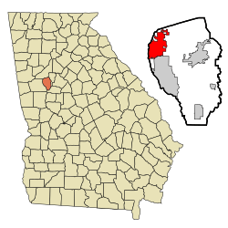
Location in Fayette County and the state of Georgia
|
|
| Country | United States |
| State | Georgia |
| County | Fayette |
| Named for | County Tyrone |
| Area | |
| • Total | 12.88 sq mi (33.36 km2) |
| • Land | 12.51 sq mi (32.39 km2) |
| • Water | 0.38 sq mi (0.97 km2) |
| Elevation | 981 ft (299 m) |
| Population
(2020)
|
|
| • Total | 7,658 |
| • Density | 612.35/sq mi (236.44/km2) |
| Time zone | UTC-5 (Eastern (EST)) |
| • Summer (DST) | UTC-4 (EDT) |
| ZIP code |
30290
|
| Area code(s) | 770, 678 |
| FIPS code | 13-78044 |
| GNIS feature ID | 0324475 |
| Major airport | ATL |
Tyrone is a friendly town located in Fayette County, Georgia, in the United States. In 2020, about 7,658 people lived there. It's part of the big Atlanta area, which means it's close to a major city.
Contents
Discovering Tyrone's Past: How the Town Began
Tyrone became an official town in 1911. The Georgia General Assembly helped make this happen. The town's name comes from a place called County Tyrone in Northern Ireland.
Exploring Tyrone's Location and Size
Tyrone is found in the northwest part of Fayette County. It is next to Peachtree City to the south. To the west, it borders Coweta County. Fulton County is to its north.
Georgia State Route 74 runs through Tyrone. This road, also known as the Joel Cowan Parkway, goes north about 5 miles (8 km). It connects to Interstate 85 near Fairburn. Downtown Atlanta is about 25 miles (40 km) northeast of Tyrone. You can get there using SR 74 and I-85.
The United States Census Bureau says Tyrone covers about 12.88 square miles (33.3 square kilometers). Most of this area is land. About 0.38 square miles (1.0 square kilometer) is water.
Who Lives in Tyrone? A Look at the Population
| Historical population | |||
|---|---|---|---|
| Census | Pop. | %± | |
| 1930 | 128 | — | |
| 1940 | 118 | −7.8% | |
| 1950 | 156 | 32.2% | |
| 1960 | 124 | −20.5% | |
| 1970 | 131 | 5.6% | |
| 1980 | 1,038 | 692.4% | |
| 1990 | 2,724 | 162.4% | |
| 2000 | 3,916 | 43.8% | |
| 2010 | 6,879 | 75.7% | |
| 2020 | 7,658 | 11.3% | |
| U.S. Decennial Census | |||
The table above shows how Tyrone's population has grown over the years. In 2020, there were 7,658 people living in the town. These people made up 2,506 households.
Understanding Tyrone's Diverse Community
| Race | Num. | Perc. |
|---|---|---|
| White (non-Hispanic) | 4,186 | 54.66% |
| Black or African American (non-Hispanic) | 2,357 | 30.78% |
| Native American | 17 | 0.22% |
| Asian | 298 | 3.89% |
| Pacific Islander | 4 | 0.05% |
| Other/mixed | 364 | 4.75% |
| Hispanic or Latino | 432 | 5.64% |
This table shows the different backgrounds of people living in Tyrone in 2020. It helps us see the variety of cultures and communities that make up the town.
Learning in Tyrone: Schools and Education
Tyrone has several schools for students. There are three public schools right in town. They are Burch Elementary, Flat Rock Middle, and Sandy Creek High School. All three are located on Jenkins Road.
Our Lady of Victory Catholic School is another option. It is on Kirkley Road, just off Highway 74. Outside the town, you can find Crabapple Elementary School to the south. Bennett's Mill Middle School is located to the east of town.
Famous Faces from Tyrone
Many talented people have lived in Tyrone. Here are a few:
- Joey Clanton – A professional NASCAR driver.
- Calvin Johnson – A former NFL wide receiver. He is now in the Pro Football Hall of Fame.
- Brian Branch – An NFL safety who plays for the Detroit Lions.
- Andrew Gardner – A former NFL football player for the Miami Dolphins.
- Kedric Golston – An NFL football player who played for the Washington Redskins.
- Mike Hilton – An NFL football player for the Cincinnati Bengals.
- Jody Knowles – Another professional NASCAR driver.
- Morris Robinson – An operatic bass singer. He performs at the Metropolitan Opera.
- Brittany Swann – She was crowned Miss Georgia USA in 2007.
See also

- In Spanish: Tyrone (Georgia) para niños
 | Jackie Robinson |
 | Jack Johnson |
 | Althea Gibson |
 | Arthur Ashe |
 | Muhammad Ali |

