Union County, Mississippi facts for kids
Quick facts for kids
Union County
|
|
|---|---|

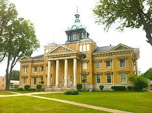
The Union County courthouse in New Albany
|
|

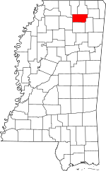
Location within the U.S. state of Mississippi
|
|
 Mississippi's location within the U.S. |
|
| Country | |
| State | |
| Founded | July 7, 1870 |
| Seat | New Albany |
| Largest city | New Albany |
| Area | |
| • Total | 417 sq mi (1,080 km2) |
| • Land | 416 sq mi (1,080 km2) |
| • Water | 1.3 sq mi (3 km2) 0.3% |
| Population
(2020)
|
|
| • Total | 27,777 |
| • Density | 66.61/sq mi (25.719/km2) |
| Time zone | UTC−6 (Central) |
| • Summer (DST) | UTC−5 (CDT) |
| Congressional district | 1st |
Union County is a county in the state of Mississippi. It was created on July 7, 1870. The county was formed from parts of Tippah and Pontotoc counties. Later, in 1874, a piece of Lee County was added.
In 2020, about 27,777 people lived in Union County. The main town and county seat is New Albany. The county seat is like the capital city for a county. It's where the main government offices are located.
The name "Union County" has a couple of possible meanings. One idea is that it got its name because it was a "union" or combination of pieces from other counties. Another idea is that the name celebrated Mississippi rejoining the United States after the Civil War.
Contents
Where is Union County Located?
Union County is in the northern part of Mississippi. The U.S. Census Bureau says the county covers a total area of about 417 square miles. Most of this area, about 416 square miles, is land. Only a small part, about 1.3 square miles, is water.
Major Roads in Union County
Several important roads run through Union County. These roads help people travel and transport goods across the county and to other areas.
 Interstate 22
 U.S. Route 78
 Mississippi Highway 9
 Mississippi Highway 15
 Mississippi Highway 30
 Mississippi Highway 178
 Mississippi Highway 348
 Mississippi Highway 349
 Mississippi Highway 355
Counties Next to Union County
Union County shares its borders with several other counties.
- Benton County (to the north)
- Tippah County (to the north)
- Prentiss County (to the east)
- Lee County (to the southeast)
- Pontotoc County (to the south)
- Lafayette County (to the southwest)
- Marshall County (to the northwest)
Protected Natural Areas
Part of the Holly Springs National Forest is located within Union County. This forest is a protected area. It helps to preserve nature and wildlife.
Who Lives in Union County?
| Historical population | |||
|---|---|---|---|
| Census | Pop. | %± | |
| 1880 | 13,030 | — | |
| 1890 | 15,606 | 19.8% | |
| 1900 | 16,522 | 5.9% | |
| 1910 | 18,997 | 15.0% | |
| 1920 | 20,044 | 5.5% | |
| 1930 | 21,268 | 6.1% | |
| 1940 | 21,867 | 2.8% | |
| 1950 | 20,262 | −7.3% | |
| 1960 | 18,904 | −6.7% | |
| 1970 | 19,096 | 1.0% | |
| 1980 | 21,741 | 13.9% | |
| 1990 | 22,085 | 1.6% | |
| 2000 | 25,362 | 14.8% | |
| 2010 | 27,134 | 7.0% | |
| 2020 | 27,777 | 2.4% | |
| 2023 (est.) | 28,284 | 4.2% | |
| U.S. Decennial Census 1790-1960 1900-1990 1990-2000 2010-2013 |
|||
The population of Union County has changed over the years. The table shows how many people have lived there since 1880. In 2020, the county had 27,777 residents. There were 9,808 households and 6,922 families living in the county.
What is the Population Makeup?
The 2020 census collected information about the different groups of people living in Union County.
| Race | Number of People | Percentage |
|---|---|---|
| White | 21,560 | 77.62% |
| Black or African American | 3,950 | 14.22% |
| Native American | 27 | 0.1% |
| Asian | 109 | 0.39% |
| Other/Mixed | 830 | 2.99% |
| Hispanic or Latino | 1,301 | 4.68% |
Towns and Communities
Union County has several towns and smaller communities. These are places where people live and work.
Main City
- New Albany is the biggest city in the county. It is also the county seat.
Towns
- Myrtle
- Sherman is a town that is partly in Union County. It also extends into Pontotoc County and Lee County.
Village
Unincorporated Communities
These are smaller areas that do not have their own local government.
- Alpine
- Enterprise
- Etta
- Ingomar
- Jugfork
- Keownville
- New Harmony
- Wallerville
Schools and Colleges
Education is important in Union County. There are two main school districts for younger students.
- New Albany Public Schools
- Union County School District
For students who want to continue their education after high school, Northeast Mississippi Community College serves Union County.
Images for kids
See also
 In Spanish: Condado de Union (Misisipi) para niños


