Valdez, Colorado facts for kids
Quick facts for kids
Valdez, Colorado
|
|
|---|---|

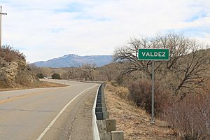
Entering Valdez from the east on Colorado State Highway 12.
|
|

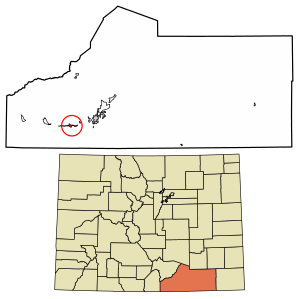
Location of the Valdez CDP in Las Animas County, Colorado.
|
|
| Country | |
| State | |
| County | Las Animas County |
| Government | |
| • Type | unincorporated community |
| Area | |
| • Total | 1.609 sq mi (4.166 km2) |
| • Land | 1.609 sq mi (4.166 km2) |
| • Water | 0 sq mi (0.000 km2) |
| Elevation | 6,500 ft (2,000 m) |
| Population
(2020)
|
|
| • Total | 46 |
| • Density | 28.60/sq mi (11.04/km2) |
| Time zone | UTC−7 (MST) |
| • Summer (DST) | UTC−6 (MDT) |
| ZIP Code |
Trinidad 81082
|
| Area code(s) | 719 |
| GNIS feature ID | 2583310 |
Valdez is a small community in Las Animas County, Colorado, United States. It is an unincorporated community, meaning it is not part of an official city or town. It is also a census-designated place (CDP), which is an area the government defines for collecting population data.
From 1907 to 1960, Valdez was a company town. This means a company, Colorado Fuel & Iron (CF&I), owned most of the homes and businesses. It was built for the workers of the Frederick coal mine, which was very important to CF&I. In 2020, 46 people lived in Valdez. The local post office is in Trinidad.
Contents
Where is Valdez Located?
Valdez is in the western part of Las Animas County. It sits in the valley of the Purgatoire River. To its west is another community called Segundo.
Colorado State Highway 12 runs along the northern edge of Valdez. If you go east on this highway, it's about 13 miles (21 km) to Trinidad, which is the main town of the county. Going west for about 20 miles (32 km) takes you to Stonewall Gap. The area of Valdez is about 4.166 square kilometers (1.6 square miles), and it's all land.
A Look at Valdez's Past
The Colorado Fuel & Iron (CF&I) company grew a lot in southern Colorado. This happened after John D. Rockefeller and later his son John D. Rockefeller Jr. invested in the company in 1903. One of their new projects was building the Valdez mine in 1907.
Soon after, the mine was renamed "Frederick." It quickly became a major producer of bituminous coal. This coal was sent to special ovens in Segundo to make coke, a type of fuel. From 1918, coal from Frederick was also sent to CF&I's Minnequa steel mill. This was part of the company's plan to control all steps of production, from mining to making steel. Early on, Apache Native Americans were often seen in the town and nearby areas.
The Rockefeller Plan
In 1913-1914, CF&I had a big conflict called the Colorado Coalfield War. This was a fight against United Mine Workers of America miners who were on strike. Valdez was one of the company towns where workers did not join the strike much. However, a very sad event called the Ludlow Massacre happened during this time. This event and the violence that followed made Rockefeller Jr. want to improve CF&I's public image.
He hired experts like Ivy Lee and William Lyon Mackenzie King (who later became Canada's prime minister) to help. Rockefeller Jr. even visited Valdez in September 1915 as part of a tour of the coal mining areas. From these efforts came the "Rockefeller Plan." This plan aimed to improve company towns and create company-led unions for workers.
Mine Production and Closure
By 1917, the Frederick mine was producing about 1,500 tons of coal every day. Around 500 men and 28 mules worked there. In 1940, trams replaced the mules, and the number of miners grew to 750. The mine was very productive. Before it closed in 1960, it had produced over 29.6 million tons of coal.
Population Changes
The United States Census Bureau first defined Valdez as a CDP for the United States Census 2010. Here's how the population has changed:
| Valdez CDP, Colorado | ||
|---|---|---|
| Year | Pop. | ±% |
| 2010 | 47 | — |
| 2020 | 46 | −2.1% |
| Source: United States Census Bureau | ||
See also
 In Spanish: Valdez (Colorado) para niños


