
Via Podiensis facts for kids

The Via Podiensis, also known as the Le Puy Route, is a famous walking path in France. It's one of four main routes that people have used for centuries to travel across France. These paths lead to the tomb of Saint James the Great in Santiago de Compostela, a city in northwest Spain.
The Le Puy Route starts in a town called Le-Puy-en-Velay. It winds through the French countryside until it reaches a Basque village named Ostabat. Near Ostabat, this route joins up with two other French pilgrimage paths: the Via Turonensis and the Via Lemovicensis.
Once these three routes meet, they become the Navarre Route. This combined path goes through the French town of Saint-Jean-Pied-de-Port. From there, walkers cross the Pyrenees mountains into Spain, arriving at Roncesvalles in the Spanish region of Basse-Navarre. This long journey across Spain is known as the Camino francés, which means "French Way."
There's also a fourth French route, the Via Tolosane. It crosses the Pyrenees at a different spot called Somport. When it enters Spain, it becomes the Aragonese Way and later connects with the Camino Francés further west.
Before the Le Puy Route even begins, another path called the via Gebennensis starts in Geneva, Switzerland. This route gathers pilgrims from Switzerland and Germany. It then connects with the Via Podiensis, adding more walkers to the journey. Even though the Via Gebennensis has a Latin name, it's a newer path created in the 1980s and 90s. However, many old "hospitals" (places for travelers to rest) along its way show that pilgrims used parts of this route long ago.
Today, the Via Gebennensis and Via Podiensis are marked as one of France's major hiking trails, known as the GR 65. There are a few small changes or detours, like the GR 651 through the Célé valley and the GR 652 which passes through Rocamadour.
Contents
A Look Back: History of the Route

Long ago, in the 12th century, a guide for travelers was written. It was called "A Guide for the Traveller" and was part of a larger book known as the Codex Calixtinus. This guide described four main routes that led to Santiago de Compostela:
- The Via Turonensis: This path started in Paris and went through Tours.
- The Via Lemovicensis: This route began in Vézelay and passed through Limoges.
- The Via Podiensis: This is our route, starting in Puy-en-Velay and going through places like Cahors and Moissac.
- The Via Tolosane: This path started in Arles and went through Toulouse.
A very important event happened around the year 950 or 951. A bishop named Godescalc, from Le Puy-en-Velay, decided to go on the pilgrimage to Santiago de Compostela. He was the first person from outside Spain to make this long journey. He led a very large group, including church leaders, their helpers, noble people, and even soldiers. This showed how important and popular these pilgrimages were becoming.
Walking the Modern Route


The modern Via Podiensis follows much of the ancient path. It's well-marked, making it easier for today's hikers and pilgrims to find their way. You'll often see special signs: a yellow shell on a blue background, or arrows. Sometimes, you'll see an "X" mark, which means "this is not the path."
The route passes through several different regions of France:
Through Haute-Loire
The journey begins in Le Puy-en-Velay. From there, the path goes through towns like Vals-près-le-Puy, Saint-Christophe-sur-Dolaison, and Saugues.
Through Lozère
Next, the route enters the Lozère region. Here, you'll walk through places such as Saint-Alban-sur-Limagnole, Aumont-Aubrac, and Nasbinals.
Through Aveyron
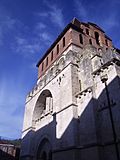
In Aveyron, the path continues through Aubrac, Saint-Chély-d'Aubrac, and Espalion. A very famous stop on the route in this region is the beautiful town of Conques.
Through Lot
The route then reaches the Lot region, passing through Montredon and Figeac. There are a few different ways to walk through this area:
- One path follows the Lot river valley, going through Cajarc.
- Another path goes through the Célé valley, visiting places like Marcilhac-sur-Célé and Saint-Cirq-Lapopie.
These two paths eventually meet up again.
- A third option goes north of the main route, leading to the famous pilgrimage site of Rocamadour.
All these paths eventually lead to the historic city of Cahors.
Through Tarn-et-Garonne
After Cahors, the route continues into Tarn-et-Garonne, passing through towns like Moissac and Auvillar.
Through Gers
The path then enters the Gers region.
Through Landes
In Landes, the route goes through Aire-sur-l'Adour. From here, walkers can choose between two small detours, one through Pécorade and the other through Miramont-Sensacq. Both paths meet up again at Pimbo.
Through Pyrénées-Atlantiques

Finally, the route reaches the Pyrénées-Atlantiques region, the last part of the journey in France. It passes through towns like Navarrenx, Saint-Palais, and Ostabat. The very last French town on the route is Saint-Jean-Pied-de-Port.
The final part of the Via Podiensis involves crossing the Roncevaux Pass in the Pyrenees mountains. This pass is high up, at 1057 meters (about 3,468 feet). After crossing, pilgrims arrive at the village of Roncesvalles in Spain. From Roncesvalles, it's still about 738 kilometers (459 miles) to reach Santiago de Compostela.
Gallery
-
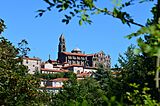
The Cathedral of Our Lady of the Annunciation in Le-Puy-en-Velay.
-
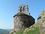
Perched chapel near Saint-Private-d’Allier.
-
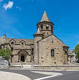
Saint Mary’s Church in Nasbinals.
-
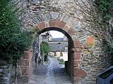
Arch way in Conques.
-
Célé River in Figeac.
-
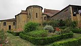
Saint Peter’s Abbey, Moissac.
-
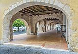
Arcades in Montreal-du-Gers.
-
Collegial of Saint Barthélémy in Pimbo.
-
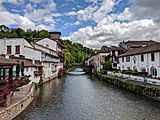
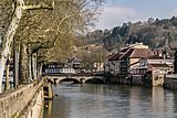
Saint-Jean-Pied-de-Port.


.jpg)
.jpg)


See also
 In Spanish: Camino de Le Puy para niños
