Victoria Island (Ottawa River) facts for kids
|
Native name:
Asinabka
|
|
|---|---|
 |
|
| Geography | |
| Location | Ottawa River |
| Coordinates | 45°25′15″N 75°42′46″W / 45.42083°N 75.71278°W |
| Area | 5.6 ha (14 acres) |
| Length | 724 m (2,375 ft) |
| Width | 205 m (673 ft) |
| Highest elevation | 54 m (177 ft) |
| Highest point | Booth Street |
| Administration | |
|
Canada
|
|
| Province | Ontario |
| Census Division | Ottawa |
| Ward | Somerset Ward |
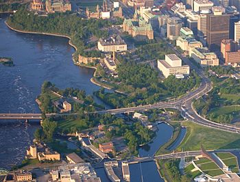
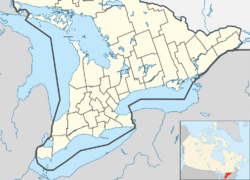
Victoria Island, also known as Île Victoria in French and Asinabka in Algonquin, is an island in the Ottawa River. It is located just north of LeBreton Flats in Ottawa, Ontario. The island is very important to the local Algonquian peoples. They use it for special ceremonies and sometimes for peaceful protests. Victoria Island is part of a group of islands found near Chaudière Falls. Other islands in this group include Chaudière Island and Albert Island.
Two bridges, the Portage Bridge and the Chaudière Bridge, cross Victoria Island. These bridges connect Ottawa in Ontario to Gatineau, Quebec, on the other side of the river. Currently, people cannot visit the island freely. This is because a big project to clean up the environment is happening there. This cleanup project is expected to finish in 2025 and cost about $13 million.
Island History
Indigenous people lived in this area as far back as 9,000 years ago. They used Victoria Island as a place to carry their canoes and goods between waterways. It was also a busy spot for trading. The nearby Chaudière Falls were used for important ceremonies, meetings, and as a burial ground.
The island was later named after Queen Victoria. Starting in the 1800s, homes, shops, and different industries were built there. These included a sawmill, ironworks, and other factories. In 1900, the Wilson Carbide Mill was built on the island. This four-story stone building was named after Thomas Willson. He invented a way to make calcium carbide and acetylene gas. The mill made calcium carbide. Today, this building is recognized as an important Federal Heritage Building.
Over time, the industrial use of the island caused pollution. This led to the current cleanup operation. Tests done in 2017 showed that the island's soil, groundwater, and surface water were polluted. They contained things like ashes, lead, zinc, and fuel oil. The National Capital Commission (NCC) bought most of the island in the 1960s. They acquired the rest of it from Public Services and Procurement Canada in 2018.
Peaceful Protests
Victoria Island has a long history of being a place for Indigenous protests. In 1974, a group called "The Native People's Caravan" peacefully occupied the Carbide Mill. Later, in 1995, protesters from the Aboriginal Defence League entered the mill and set up an "Aboriginal Embassy."
In 1988, the Algonquins of Barriere Lake set up tents on the island. They were protesting concerns about their land by the federal and Quebec governments. They returned in 1990, partly to show support for the Mohawk people during the Oka Crisis. In 2013, Attawapiskat First Nation chief Theresa Spence stayed on the island to protest against the Government of Canada.
The Island's Future
After the environmental cleanup project is finished, the NCC has plans for Victoria Island. They want to work with the Algonquin Anishinaabe Nation. Together, they will create a plan for the island's future. The goal is to reopen it to the public so everyone can enjoy this special place.
See also
- Royal eponyms in Canada
 | Madam C. J. Walker |
 | Janet Emerson Bashen |
 | Annie Turnbo Malone |
 | Maggie L. Walker |


