Wahpenayo Peak facts for kids
Quick facts for kids Wahpenayo Peak |
|
|---|---|

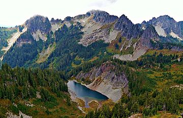
Wahpenayo Peak (centered) seen from Denman Peak with Cliff Lake and Chutla Peak to far right
|
|
| Highest point | |
| Elevation | 6,231 ft (1,899 m) |
| Prominence | 791 ft (241 m) |
| Geography | |
| Location | Mount Rainier National Park Lewis County, Washington, U.S. |
| Parent range | Cascades |
| Topo map | USGS Wahpenayo Peak |
| Climbing | |
| Easiest route | Scrambling class 3 |
Wahpenayo Peak is a mountain peak that stands 6,231 feet (about 1,900 meters) tall. It is part of the Tatoosh Range, which is a smaller mountain group within the larger Cascade Range. You can find Wahpenayo Peak south of Mount Rainier inside Mount Rainier National Park. It is located in Lewis County in Washington state. The mountain gets its name from Wahpenayo, a Native American chief. He was the father-in-law of a famous local figure known as Indian Henry. Water from rain and melting snow on the south and east sides of the peak flows into streams that join the Cowlitz River. Water from the north side flows into streams that join the Nisqually River.
Contents
Understanding the Climate at Wahpenayo Peak
Wahpenayo Peak is in a special weather area called the marine west coast climate zone. This type of climate is found in western North America.
How Weather Forms in the Cascades
Most of the weather systems that affect this area start over the Pacific Ocean. These systems, called weather fronts, usually travel northeast towards the Cascade Mountains. When these fronts reach the tall peaks of the Cascades, the air is forced to rise. This process is called orographic lift. As the air rises, it cools down and drops its moisture. This moisture falls as rain or snow onto the mountains.
Rainfall and Snowfall Patterns
Because of this effect, the western side of the North Cascades gets a lot of rain and snow. This is especially true during the winter months, when heavy snowfall is common. In winter, the sky is often cloudy. However, during the summer, large areas of high air pressure form over the Pacific Ocean. These high-pressure systems often bring clear skies and sunny weather to the mountains.
Snow Conditions and Safety
Due to the influence of the ocean, the snow in this area tends to be wet and heavy. This type of snow can increase the risk of avalanches. An avalanche is a large slide of snow down a mountainside. It is important to be aware of avalanche danger when visiting snowy mountain areas.
- Weather forecast: Wahpenayo Peak
- National Park Service web site: Mount Rainier National Park
 | Madam C. J. Walker |
 | Janet Emerson Bashen |
 | Annie Turnbo Malone |
 | Maggie L. Walker |


