
Chutla Peak facts for kids
Quick facts for kids Chutla Peak |
|
|---|---|
 |
|
| Highest point | |
| Elevation | 6,007 ft (1,831 m) |
| Prominence | 600 ft (180 m) |
| Geography | |

Chutla Peak
Location in Washington (state)

Chutla Peak
Location in the United States
|
|
| Location | Mount Rainier National Park, Washington, U.S. |
| Parent range | Cascades |
| Topo map | USGS Mount Rainier West |
| Climbing | |
| Easiest route | Scrambling class 3 |
Chutla Peak is a mountain peak located in the Tatoosh Range. This range is a smaller part of the much larger Cascade Range. Chutla Peak is found south of the famous Mount Rainier and is located within Mount Rainier National Park.
The name "Chutla" comes from an old language called Chinook Jargon. In this language, "Chutla" means "rock." Water from rain and melting snow on the peak flows into the Nisqually River.
Mountain Weather
Chutla Peak is in a special weather area known as the marine west coast climate zone. This means it gets a lot of moisture from the Pacific Ocean.
Most weather systems start over the Pacific Ocean and move northeast. When these systems reach the Cascade Mountains, the tall peaks force the air to rise. As the air goes higher, it cools down and drops its moisture. This moisture falls as rain or snow on the mountains. This process is called Orographic lift.
Because of this, the western side of the Cascade Mountains gets a lot of rain and snow, especially in winter. The weather here is usually cloudy during winter. However, in summer, high-pressure systems over the Pacific Ocean often bring clear skies.
The climate near the ocean keeps temperatures mild. It rarely gets colder than 0 °F (−18 °C) (which is about -18°C) or warmer than 80 °F (27 °C) (about 27°C). Because the snow is often wet and heavy due to the ocean's influence, there can be a high risk of avalanches.
Learn More
- You can find more information about the park on the official National Park Service website: Mount Rainier National Park
Images for kids
-
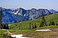
Chutla Peak and Eagle Peak seen from a meadow above Paradise
.jpeg)
