Waithe facts for kids
Quick facts for kids Waithe |
|
|---|---|
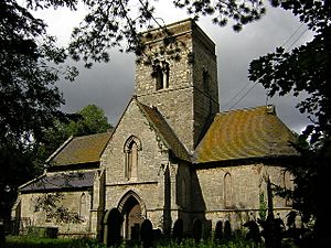
 St Martin's Church, Waithe |
|
| OS grid reference | TA282006 |
| • London | 140 mi (230 km) S |
| District | |
| Shire county | |
| Region | |
| Country | England |
| Sovereign state | United Kingdom |
| Post town | Grimsby |
| Postcode district | DN36 |
| Police | Lincolnshire |
| Fire | Lincolnshire |
| Ambulance | East Midlands |
| EU Parliament | East Midlands |
| UK Parliament |
|
Waithe (or Waythe) is a small village, called a hamlet, and a civil parish in Lincolnshire, England. It is part of the East Lindsey district. You can find Waithe on the A16, about 1 mile (1.6 km) south of Holton-le-Clay. It is also about 1 mile (1.6 km) north of North Thoresby.
Contents
Exploring Waithe's Past
The name 'Waithe' comes from an old English word, wæd. This word means 'ford', which is a shallow place in a river or stream where you can cross.
Waithe in the Domesday Book
Waithe is mentioned in the famous Domesday Book. This book was a huge survey of England ordered by William the Conqueror in 1086. In the Domesday Book, Waithe was called "Wade". It was part of an area known as the Haverstoe Hundred.
In 1086, Waithe had about 30 households. There were four villagers and one freeman. The land was used for farming, with some areas for ploughing and meadows for animals. Before 1066, a person named Siward Barn was the lord of the manor (the main landowner). After the Norman Conquest, this role went to Odo of Bayeux. Ivo Taillebois was the Tenant-in-chief for King William I.
The Lost Medieval Village
Waithe is also the site of a deserted medieval village. This means a village that was once there, but people left it long ago. We know this because of special marks on the ground called earthworks. These are old banks, ditches, and paths that show where buildings and fields once were. Pottery pieces from the 13th to 18th centuries have also been found here.
Life in Waithe: 19th Century Insights
In 1872, a book called White's Directory described Waithe (spelled 'Waith'). It said it was a small parish with 58 people. The land was about 780 acres (3.2 km²) and was very "fertile," meaning good for growing crops. The lord of the manor was also in charge of the local church.
St Martin's Church was described as a "neat structure." It was built in the Early English style. Part of the church was rebuilt in 1869. The local priest lived in a nearby village called Grainsby. People from Waithe could also go to special homes for the poor, called almshouses, in Ashby cum Fenby. In 1872, people in Waithe worked as farmers, a grazier (someone who raises livestock), and a corn miller.
By 1885, Kelly's Directory reported more about farming in Waithe. The 780-acre parish mainly grew wheat, oats, turnips, and barley. Farmers used a four-field system to keep the soil healthy.
Important Places in Waithe
St Martin's Church: A Historic Building
Waithe is home to St Martin's Church. This church is a Grade I listed building. This means it is a very important historical building that needs to be protected. The church was rebuilt in 1861 by an architect named James Fowler.
When it was rebuilt, only the Early English nave arcades and tower remained from an older Saxon church. A Saxon church is one built during the Anglo-Saxon period, long before the Normans arrived. The church was repaired and looked after in 2005.
Waithe Water Mill
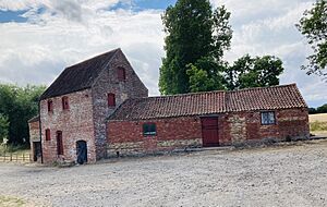
Another important building in Waithe is the Water Mill. This mill is also a Grade II listed structure. It was built in 1813. Water mills use the power of flowing water to grind grain or do other work.
 | Janet Taylor Pickett |
 | Synthia Saint James |
 | Howardena Pindell |
 | Faith Ringgold |


