Walhalla, North Dakota facts for kids
Quick facts for kids
Walhalla, North Dakota
|
|
|---|---|

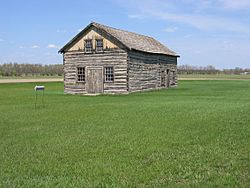
Walhalla Trading Post
|
|
| Motto(s):
"Heart of the Rendezvous Region"
|
|

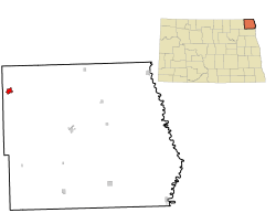
Location of Walhalla, North Dakota
|
|
| Country | United States |
| State | North Dakota |
| County | Pembina |
| Established | 1845 |
| Founded | 1871 |
| Area | |
| • Total | 1.05 sq mi (2.72 km2) |
| • Land | 1.03 sq mi (2.68 km2) |
| • Water | 0.02 sq mi (0.04 km2) |
| Elevation | 991 ft (302 m) |
| Population
(2020)
|
|
| • Total | 893 |
| • Estimate
(2022)
|
897 |
| • Density | 862.80/sq mi (332.99/km2) |
| Time zone | UTC-6 (Central (CST)) |
| • Summer (DST) | UTC-5 (CDT) |
| ZIP code |
58282
|
| Area code(s) | 701 |
| FIPS code | 38-82980 |
| GNIS feature ID | 1036314 |
| Highways | ND 32 |
Walhalla is a city located in Pembina County, North Dakota, in the United States. It is built along the Pembina River. Walhalla is about 5 miles (8 km) from the border with Manitoba, Canada. It is also about 45 miles (72 km) from the border with Minnesota. In 2020, the city had a population of 893 people.
Contents
History of Walhalla
Walhalla was founded in 1845, making it the second oldest town in North Dakota. Its early history is closely linked to the fur trade in the Red River Valley.
Early Trading Posts
A fur trading post was set up near Walhalla in 1797 by David Thompson. He was a British-Canadian surveyor and mapmaker. This post was moved in 1801, and a rebuilt version stands there today.
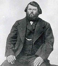
The Gingras Trading Post was built in the 1840s. It was started by Antoine Blanc Gingras, a Métis leader and businessman. This site is about one mile northeast of Walhalla.
The Kittson Trading Post was built in 1843 by Norman Kittson. He worked for the American Fur Company. This building is the oldest in North Dakota. It is now part of the Walhalla State Historical Park. The State Historical Society helps to keep it safe.
Later Developments
The Great Northern Railway reached Walhalla in 1898. This helped the town grow and connect with other places.
Geography of Walhalla
Walhalla covers a total area of about 1.07 square miles (2.72 square kilometers). Most of this area is land, about 1.05 square miles (2.68 square kilometers). A small part, about 0.02 square miles (0.04 square kilometers), is water.
Population and People
| Historical population | |||
|---|---|---|---|
| Census | Pop. | %± | |
| 1880 | 67 | — | |
| 1900 | 377 | — | |
| 1910 | 592 | 57.0% | |
| 1920 | 637 | 7.6% | |
| 1930 | 700 | 9.9% | |
| 1940 | 1,138 | 62.6% | |
| 1950 | 1,463 | 28.6% | |
| 1960 | 1,432 | −2.1% | |
| 1970 | 1,471 | 2.7% | |
| 1980 | 1,429 | −2.9% | |
| 1990 | 1,131 | −20.9% | |
| 2000 | 1,057 | −6.5% | |
| 2010 | 996 | −5.8% | |
| 2020 | 893 | −10.3% | |
| 2022 (est.) | 897 | −9.9% | |
| U.S. Decennial Census 2020 Census |
|||
Walhalla's Population in 2010
In 2010, Walhalla had 996 people living there. There were 439 households in the city. About 26.9% of these households had children under 18. Many households (48.1%) were married couples.
Most of the people in Walhalla were White (88.3%). About 8.7% were Native American. A small number of people were from other races.
The average age of people in Walhalla was 45.5 years. About 23.8% of residents were under 18 years old.
Local Media
From 1896 until 2020, Walhalla had its own weekly newspaper called The Walhalla Mountaineer. Nearby towns like Langdon and Cavalier still have their own weekly newspapers.
For TV and radio, Walhalla is part of the Grand Forks media market. This means people in Walhalla get their news and shows from Grand Forks.
Things to Do in Walhalla
Walhalla offers some fun activities and sights:
- Frost Fire Ski and Snow Board Area: A place for skiing and snowboarding.
- Scenic overviews: Beautiful spots to see the landscape.
Climate in Walhalla
Walhalla has a humid continental climate. This type of climate has big changes in temperature throughout the year. Summers are usually warm to hot, and sometimes humid. Winters are cold, and can be very cold. This climate is often shown as "Dfb" on climate maps.
See also
 In Spanish: Walhalla (Dakota del Norte) para niños
 | Janet Taylor Pickett |
 | Synthia Saint James |
 | Howardena Pindell |
 | Faith Ringgold |


