Wallsend, New South Wales facts for kids
Quick facts for kids WallsendNewcastle, New South Wales |
|||||||||||||||
|---|---|---|---|---|---|---|---|---|---|---|---|---|---|---|---|

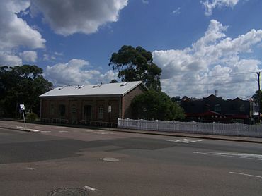
Railway Goods Shed building (1860s and 1870s).
|
|||||||||||||||
| Population | 12,470 (2016 census) | ||||||||||||||
| • Density | 1,022/km2 (2,650/sq mi) | ||||||||||||||
| Postcode(s) | 2287 | ||||||||||||||
| Elevation | 9 m (30 ft) | ||||||||||||||
| Area | 12.2 km2 (4.7 sq mi) | ||||||||||||||
| Location |
|
||||||||||||||
| LGA(s) |
|
||||||||||||||
| Parish | Kahibah | ||||||||||||||
| State electorate(s) | Wallsend | ||||||||||||||
| Federal Division(s) | |||||||||||||||
|
|||||||||||||||
Wallsend is a suburb located in the western part of Newcastle, Australia. It is about 11 kilometers (7 miles) from Newcastle's main city area. Wallsend is special because it sits across two different local government areas: the City of Newcastle and the City of Lake Macquarie.
Contents
A Look Back: Wallsend's Story
First Peoples of Wallsend
The land where Wallsend is located has a very long history. The Awabakal and Worimi peoples are the traditional owners of this land. They have lived here for thousands of years. Their culture and heritage are deeply connected to the rivers, creeks, and coastlines of Newcastle.
An early explorer, Lieutenant Edward Close, noted an Aboriginal name for part of the Wallsend area. It was called Barrahinebin. This name described the land between the Hunter River, Ironbark Creek, and Mount Sugarloaf.
How Wallsend Got Its Name
Wallsend got its name from a coal mining town in the north of England. That English town was built at the end of a famous Roman wall called Hadrian's Wall.
In the 1850s, a man named Alexander Brown bought land in this area. He decided to name it Wallsend. The company he started to mine coal, which opened in 1861, was called the Newcastle-Wallsend Coal Company.
Wallsend's Mining Past
Wallsend started as two separate mining towns: Wallsend and Plattsburg. Wallsend grew bigger and eventually connected with Plattsburg through Nelson Street. In 1874, Wallsend became its own municipality. However, by 1915, the two areas had joined together again.
The coal found in Wallsend was very good quality. This helped the town grow and become a busy commercial center, which it still is today.
Wallsend Today: A Growing Community
Today, Wallsend is much larger than its original main street. It has seen a lot of new businesses and investments. The main street has changed too, with new restaurants and real estate offices. Many local businesses have moved to the bigger Wallsend Village shopping center. This shows how much the area has grown and developed.
Learning in Wallsend: Schools
Wallsend has several schools for young people.
- Plattsburg Public School is a government school for both boys and girls. It is located on Ranclaud Street.
- Wallsend Public School is another government primary school. It is for boys and girls and is found on Martindale Street.
- St Patrick's Primary School is a Catholic primary school. It also teaches both boys and girls and is on Macquarie Street.
- Wallsend junior campus is part of Callaghan Campus. It is a government high school for students in years 7 to 10. You can find it on Macquarie Street.
Historic Places in Wallsend
Wallsend has some important historical sites. These places are protected because they are part of the area's heritage.
- 76 Cowper Street: This is the Wallsend Railway Goods Shed. It's a building from the past that was used for railway goods.
Sports and Fun in Wallsend
Wallsend offers many sports activities for its community.
- Wallsend Racecourse
- Fletcher Football Club
- Wallsend Athletics Club
- Wallsend Touch Football Association
 | Isaac Myers |
 | D. Hamilton Jackson |
 | A. Philip Randolph |


