Warcop facts for kids
Quick facts for kids Warcop |
|
|---|---|
 Warcop |
|
| Population | 532 (2011) |
| OS grid reference | NY7214 |
| Civil parish |
|
| District | |
| Shire county | |
| Region | |
| Country | England |
| Sovereign state | United Kingdom |
| Post town | APPLEBY IN WESTMORLAND |
| Postcode district | CA16 |
| Dialling code | 01768 |
| Police | Cumbria |
| Fire | Cumbria |
| Ambulance | North West |
| EU Parliament | North West England |
| UK Parliament |
|
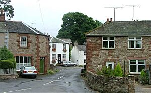
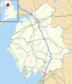
Warcop is a small village and a local area (called a civil parish) in the Eden district of Cumbria, England. In 2011, about 532 people lived there.
The village is located close to the A66 road. It is about 8 kilometers (5 miles) north of Kirkby Stephen and 8 kilometers (5 miles) south of Appleby-in-Westmorland.
Contents
What's in a Name? The Meaning of Warcop
The name Warcop tells us something about the village's landscape. It means 'hill with a cairn'. A cairn is a pile of stones, often built as a landmark or a memorial.
The name comes from two old words. Varða is an Old Norse word from the Viking Age, meaning 'cairn'. Copp is an Old English word meaning 'a summit' or 'hill top'.
In the 13th century and even earlier, the village was spelled Warthecopp. Over time, the local lords of the manor, who owned the land, changed their family name from Warthecopp to Warcop.
A Journey Through Time: Warcop's History
Warcop has a long and interesting history, with buildings and traditions that go back hundreds of years.
Ancient Roots: Roman Camps and Norman Churches
The local church, St Columba's Church, Warcop, is a very old building. It is a Norman church, which means it was built in the style popular after the Normans came to England in 1066. This church was built on the site of an even older Roman marching camp. Roman soldiers would set up these camps when they were on the move.
Every year in late June, the church holds a special event called the "Rushbearing Festival." This is a traditional celebration where rushes (a type of plant) are carried to the church.
Oldest Bridge and Historic Homes
Warcop is home to the oldest bridge that can still be used over the River Eden. This bridge was built in the 14th century or even earlier, making it hundreds of years old!
Many houses in the village are also very old. Warcop Tower dates back to around 1400, and Warcop Hall was built around 1500. Other homes were built in the 17th or 18th centuries, and some are much newer. Warcop was part of an area called Westmorland until 1974.
Railway Connections and Military Training
Warcop used to have its own train station, Warcop railway station, which opened in 1862. It closed in 1962. Today, the old station yard is part of the Eden Valley Railway, which is a special railway that uses old trains for fun trips.
The Ministry of Defence (which is in charge of the UK's armed forces) has a large training area near Warcop. This area, called the Warcop Training Area, is used for training soldiers and tank crews.
How Warcop is Governed
Warcop is part of an electoral ward (a local voting area) with the same name. This ward stretches north to Murton. In 2011, the total population of this larger area was 1,352 people.
Warcop's Weather: A Look at the Climate
The weather in Warcop is typical for this part of England. Here's a quick look at the average temperatures and rainfall:
| Climate data for Warcop, Elevation: 227 m (745 ft), 1991–2020 normals | |||||||||||||
|---|---|---|---|---|---|---|---|---|---|---|---|---|---|
| Month | Jan | Feb | Mar | Apr | May | Jun | Jul | Aug | Sep | Oct | Nov | Dec | Year |
| Mean daily maximum °C (°F) | 5.8 (42.4) |
6.3 (43.3) |
8.3 (46.9) |
11.2 (52.2) |
14.4 (57.9) |
16.8 (62.2) |
18.7 (65.7) |
18.0 (64.4) |
15.8 (60.4) |
12.2 (54.0) |
8.7 (47.7) |
6.3 (43.3) |
11.9 (53.4) |
| Daily mean °C (°F) | 3.4 (38.1) |
3.6 (38.5) |
5.1 (41.2) |
7.4 (45.3) |
10.2 (50.4) |
12.8 (55.0) |
14.8 (58.6) |
14.4 (57.9) |
12.3 (54.1) |
9.2 (48.6) |
6.0 (42.8) |
3.7 (38.7) |
8.6 (47.4) |
| Mean daily minimum °C (°F) | 1.0 (33.8) |
0.9 (33.6) |
1.8 (35.2) |
3.6 (38.5) |
6.0 (42.8) |
8.9 (48.0) |
10.9 (51.6) |
10.8 (51.4) |
8.8 (47.8) |
6.1 (43.0) |
3.3 (37.9) |
1.0 (33.8) |
5.3 (41.5) |
| Average precipitation mm (inches) | 93.7 (3.69) |
76.3 (3.00) |
62.6 (2.46) |
50.6 (1.99) |
52.9 (2.08) |
63.3 (2.49) |
75.9 (2.99) |
89.7 (3.53) |
74.0 (2.91) |
94.2 (3.71) |
101.3 (3.99) |
104.2 (4.10) |
938.7 (36.94) |
| Average precipitation days (≥ 1.0 mm) | 14.9 | 12.7 | 12.3 | 10.9 | 10.7 | 11.3 | 12.3 | 13.0 | 11.8 | 15.3 | 16.1 | 15.5 | 156.8 |
| Source: Met Office | |||||||||||||
Where is Warcop? Nearby Places
Warcop is surrounded by other small villages and areas. Here's a quick guide to what's around it:
 |
Hilton |  |
||
| Sandford | Flitholme | |||
| Soulby |
 | Selma Burke |
 | Pauline Powell Burns |
 | Frederick J. Brown |
 | Robert Blackburn |


