Wasatch County, Utah facts for kids
Quick facts for kids
Wasatch County
|
||
|---|---|---|

|
||
|
||

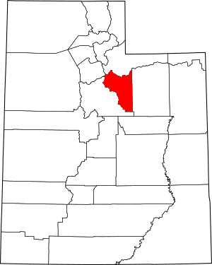
Location within the U.S. state of Utah
|
||
 Utah's location within the U.S. |
||
| Country | ||
| State | ||
| Founded | 1862 | |
| Named for | Ute word for mountain pass | |
| Seat | Heber City | |
| Largest city | Heber City | |
| Area | ||
| • Total | 1,206 sq mi (3,120 km2) | |
| • Land | 1,176 sq mi (3,050 km2) | |
| • Water | 30 sq mi (80 km2) 2.5% | |
| Population
(2020)
|
||
| • Total | 34,788 | |
| • Density | 28.846/sq mi (11.137/km2) | |
| Time zone | UTC−7 (Mountain) | |
| • Summer (DST) | UTC−6 (MDT) | |
| Congressional district | 3rd | |
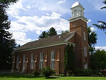
Wasatch County is a county in the state of Utah, USA. A county is like a smaller area within a state. As of 2020, about 34,788 people live there. The main city and government center is Heber City.
The name "Wasatch" comes from a word in the Ute language. It means "mountain pass" or "a low place in high mountains." Wasatch County is part of a larger area around Salt Lake City, Provo, and Orem.
Contents
History of Wasatch County
Who were the first settlers in Wasatch County?
The first people to settle in this area were Mormon pioneers. They arrived in 1859. They built their homes near where Heber City, Midway, and Charleston are today.
When was Wasatch County created?
On January 17, 1862, the government of Utah Territory officially created Wasatch County. They took parts from other counties like Great Salt Lake and Summit. Heber City was chosen as the county seat, which is where the county's main offices are.
How did Wasatch County get its name?
The name "Wasatch" comes from the Ute language. It means "mountain pass" or "a low pass over a high mountain range." Heber City was named after Heber C. Kimball, an important leader in the Mormon church. The county's borders changed a few times. In 1915, the eastern part became Duchesne County. Wasatch County's borders have stayed the same since then.
Geography of Wasatch County
What is the climate like in Wasatch County?
Heber Valley, where much of the county is, has a cool climate. This is because it is surrounded by mountains. More than half of the land is about 7,500 feet (2,286 meters) above sea level. On average, the county gets about 16 inches (406 mm) of rain and snow each year.
What are the main rivers and mountains in Wasatch County?
The county has two main water systems. Some water flows towards the Colorado River, and some flows into the Great Basin. Daniels, Lake Fork, and Center creeks flow from the east. The Provo River flows from the north and northeast. Snake Creek flows from the west. The highest point in Wasatch County is on the west side of Murdock Mountain. It is about 10,840 feet (3,304 meters) high.
How big is Wasatch County?
Wasatch County covers a total area of 1,206 square miles (3,123 km²). Most of this is land, about 1,176 square miles (3,046 km²). The rest, about 30 square miles (78 km²), is water.
Major highways in Wasatch County
- U.S. Route 6
- U.S. Route 40
- U.S. Route 189
- Utah State Route 32
- Utah State Route 35
- Utah State Route 113
- Utah State Route 248
- Utah State Route 319
Counties next to Wasatch County
- Salt Lake County - to the northwest
- Summit County - to the north
- Duchesne County - to the east
- Utah County - to the southwest
Protected natural areas in Wasatch County
- Ashley National Forest (part)
- Currant Creek Campground (USFS)
- Currant Creek Wildlife Management Area (part)
- Deer Creek State Park
- Rock Cliff Campground (Utah State Park)
- Soldier Creek Recreational Area
- Uinta National Forest (part)
- Wasatch Mountain State Park
- Wasatch National Forest (part)
- Wildcat Mountain Wildlife Management Area
Lakes in Wasatch County
- Currant Creek Reservoir
- Deer Creek Reservoir
- Jordanelle Reservoir
- Strawberry Reservoir
- Witts Lake
Population and People of Wasatch County
How many people live in Wasatch County?
The number of people living in Wasatch County has grown a lot over the years.
| Historical population | |||
|---|---|---|---|
| Census | Pop. | %± | |
| 1870 | 1,244 | — | |
| 1880 | 2,927 | 135.3% | |
| 1890 | 3,595 | 22.8% | |
| 1900 | 4,786 | 33.1% | |
| 1910 | 8,920 | 86.4% | |
| 1920 | 4,625 | −48.2% | |
| 1930 | 5,636 | 21.9% | |
| 1940 | 5,754 | 2.1% | |
| 1950 | 5,574 | −3.1% | |
| 1960 | 5,308 | −4.8% | |
| 1970 | 5,863 | 10.5% | |
| 1980 | 8,523 | 45.4% | |
| 1990 | 10,089 | 18.4% | |
| 2000 | 15,215 | 50.8% | |
| 2010 | 23,530 | 54.7% | |
| 2020 | 34,788 | 47.8% | |
| US Decennial Census 1790–1960 1900–1990 1990–2000 2010 2020 |
|||
What was the population like in 2020?
In 2020, there were 34,788 people in Wasatch County. This means there were about 29.6 people living in each square mile. Most people, about 81%, were White. About 14.5% of the people were Hispanic or Latino.
There were slightly more males (50.78%) than females (49.22%). About 30.4% of the population was under 18 years old. The average age of people in the county was 35.3 years.
How do people live in Wasatch County?
There were 11,040 households in Wasatch County. A household is a group of people living together. Most households, about 79.4%, were families. About 66.3% of families were married couples. Many households, about 41.5%, had children under 18. Most homes, about 76.3%, were owned by the people living in them.
The average income for a household in Wasatch County was $85,807 per year. For families, the average income was $99,014. A small number of people, about 4.8%, lived below the poverty line.
Most adults in Wasatch County have finished high school. Many also have some college education or a college degree.
Communities in Wasatch County
Cities in Wasatch County
- Heber City (This is the county seat)
- Midway
- Park City (only a part of this city is in Wasatch County)
Towns in Wasatch County
- Charleston
- Daniel
- Hideout
- Independence
- Interlaken
- Wallsburg
Other communities in Wasatch County
- Timber Lakes (This is a census-designated place, meaning it's a community that is counted in the census but not officially a city or town.)
Unincorporated communities in Wasatch County
These are smaller communities that are not officially part of a city or town.
- Center Creek
- Deer Mountain
- Mayflower Mountain
- Soldier Creek Estates
- Soldier Summit
- Wildwood (part)
Former communities in Wasatch County
These communities used to exist but are no longer active or have been absorbed into other areas.
Education in Wasatch County
All schools in Wasatch County are part of the Wasatch County School District.
Images for kids
See also
 In Spanish: Condado de Wasatch para niños
 | Toni Morrison |
 | Barack Obama |
 | Martin Luther King Jr. |
 | Ralph Bunche |


