Washington County, Idaho facts for kids
Quick facts for kids
Washington County
|
||
|---|---|---|

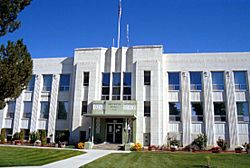
Washington County Courthouse in Weiser
|
||
|
||

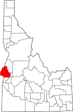
Location within the U.S. state of Idaho
|
||
 Idaho's location within the U.S. |
||
| Country | ||
| State | ||
| Founded | February 20, 1879 | |
| Named for | George Washington | |
| Seat | Weiser | |
| Largest city | Weiser | |
| Area | ||
| • Total | 1,474 sq mi (3,820 km2) | |
| • Land | 1,453 sq mi (3,760 km2) | |
| • Water | 21 sq mi (50 km2) 1.4% | |
| Population
(2020)
|
||
| • Total | 10,500 | |
| • Estimate
(2023)
|
11,425 |
|
| • Density | 7.12/sq mi (2.750/km2) | |
| Time zone | UTC−7 (Mountain) | |
| • Summer (DST) | UTC−6 (MDT) | |
| Congressional district | 1st | |
Washington County is a special area in the state of Idaho, USA. It is called a county. In 2020, about 10,500 people lived here. The main town and largest city is Weiser. More than half of the county's people live in Weiser.
Washington County was created in 1879. At that time, Idaho was still a territory, not yet a state. The county was named after George Washington, who was the first U.S. President.
Contents
Exploring Washington County's Land
Washington County covers a total area of about 1,474 square miles. Most of this area, about 1,453 square miles, is land. The rest, about 21 square miles, is water. This means about 1.4% of the county is covered by water.
Neighboring Counties
Washington County shares its borders with several other counties:
- Adams County to the north
- Gem County to the east
- Payette County to the south
- Malheur County, in Oregon, to the southwest
- Baker County, in Oregon, to the west
Main Roads
The county has important roads that help people travel:
Protected Natural Areas
Parts of these beautiful national areas are found in Washington County:
- Boise National Forest
- Deer Flat National Wildlife Refuge
- Payette National Forest
Rivers and Waterways
Two important rivers flow through the county:
Lakes and Reservoirs
You can find several reservoirs (man-made lakes) here:
- Brownlee
- Crane Creek
- Mann Creek
- Paddock Valley
Who Lives Here? Population Facts
| Historical population | |||
|---|---|---|---|
| Census | Pop. | %± | |
| 1880 | 879 | — | |
| 1890 | 3,836 | 336.4% | |
| 1900 | 6,882 | 79.4% | |
| 1910 | 11,101 | 61.3% | |
| 1920 | 9,424 | −15.1% | |
| 1930 | 7,962 | −15.5% | |
| 1940 | 8,853 | 11.2% | |
| 1950 | 8,576 | −3.1% | |
| 1960 | 8,378 | −2.3% | |
| 1970 | 7,633 | −8.9% | |
| 1980 | 8,803 | 15.3% | |
| 1990 | 8,550 | −2.9% | |
| 2000 | 9,977 | 16.7% | |
| 2010 | 10,198 | 2.2% | |
| 2020 | 10,500 | 3.0% | |
| 2023 (est.) | 11,425 | 12.0% | |
| U.S. Decennial Census 1790–1960, 1900–1990, 1990–2000, 2010 |
|||
In 2020, the county had 10,500 people living in about 4,112 homes. The county is not very crowded, with about 7 people living per square mile.
Most people in Washington County are White (about 87.6%). There are also people from other backgrounds, including Asian, Native American, Black, and Pacific Islander. About 13.75% of the population is Hispanic or Latino. Many families have roots from Germany, England, and Ireland.
About 32.7% of homes have children under 18. Most homes (60.7%) are married couples living together. The average household has about 2.61 people.
The median age in the county is 39 years old. This means half the people are younger than 39, and half are older. About 27.4% of the population is under 18.
Learning in Washington County
The county has three main school districts that serve its students:
- Weiser District #431
- Weiser High School
- Weiser Middle School
- Park Intermediate School
- Pioneer Primary School
- Cambridge Joint District #432
- Cambridge Junior-Senior High School
- Cambridge Elementary School
- Midvale District #433
- Midvale Senior High School
- Midvale Junior High School
- Midvale Elementary School
A small part of Washington County is also served by the Payette Joint School District 371. For older students, the College of Western Idaho is nearby. Its main campus is in Nampa.
Towns and Cities
These are the main towns and cities in Washington County:
Healthcare Services
The Southwest Idaho Health District helps take care of the health needs of people in the county.
See also
 In Spanish: Condado de Washington (Idaho) para niños


