Waterford (village), New York facts for kids
Quick facts for kids
Waterford
|
|
|---|---|
|
Village
|
|
| Village of Waterford | |

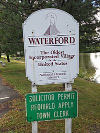
Village of Waterford gateway sign
|
|

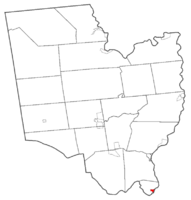
Map highlighting Waterford's location within Saratoga County.
|
|
| Country | United States |
| State | New York |
| County | Saratoga |
| Incorporated | 1794 |
| Area | |
| • Total | 0.36 sq mi (0.93 km2) |
| • Land | 0.28 sq mi (0.73 km2) |
| • Water | 0.07 sq mi (0.19 km2) |
| Elevation | 69 ft (21 m) |
| Population
(2020)
|
|
| • Total | 2,038 |
| • Density | 7,201.41/sq mi (2,782.06/km2) |
| Time zone | UTC-5 (Eastern (EST)) |
| • Summer (DST) | UTC-4 (EDT) |
| ZIP code |
12188
|
| Area code(s) | 518 |
| FIPS code | 36-78520 |
| GNIS feature ID | 0968897 |
| Website | www.waterfordny.org |

Waterford is a small village in Saratoga County, New York, United States. In 2020, about 2,038 people lived there. The village got its name from a "ford" (a shallow place to cross a river) that was once between the mainland and Peebles Island.
The Village of Waterford is located in the southeastern part of the Town of Waterford. It is just north of where the Mohawk River flows into the Hudson River.
Contents
A Look Back: Waterford's History
The area where Waterford is today was known as "Half Moon Point" in the 1600s. Mahican native people lived there at that time. The early village was built near a shallow river crossing, or ford, between Peebles Island and the mainland. This ford was located near where the Second Street Bridge is now.
Even though the Erie Canal was built and changed much of the original ford, you can still see parts of a small island that is often underwater near the canal's entrance.
Oldest Village in the USA?
Waterford claims to be the oldest village in the United States that has been continuously incorporated. It was the first village to be officially recognized by the state government in 1794. This happened when it was still part of the Town of Halfmoon. Waterford was a recognized place even before the Town of Waterford was formed.
Waterford Village is one of only twelve villages in New York that still operates under its original special charter. Most other villages in New York have changed their official rules over time.
Exploring Waterford's Geography
Waterford Village is located at 42°47′28″N 73°40′47″W / 42.79111°N 73.67972°W.
The village covers a total area of about 0.4 square miles (0.9 square kilometers). Most of this area, about 0.3 square miles (0.8 square kilometers), is land. The rest, about 0.1 square miles (0.2 square kilometers), is water.
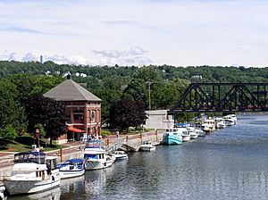
Waterford sits on the west bank of the Hudson River. It is also north of Peebles Island State Park. The village was once the furthest point boats could travel up the Hudson River. Later, it became the start of the Erie Canal and the end of the Champlain Canal.
The Famous Waterford Flight
The historic Waterford Flight is a series of locks on the Erie Canal. These locks include Lock 2, Lock 3, Lock 4, Lock 5, and Lock 6. There are also old, unused locks from the Champlain Canal here.
The Waterford Flight locks opened around 1918. They replaced older locks that allowed boats to get around the Cohoes Falls. These falls used to block all boat traffic between the Mohawk and Hudson Rivers. The Waterford Flight is known as one of the steepest series of canal locks in the world.
Rivers and Roads
Even though much of the surrounding area is high up, Waterford Village itself is very low. It is located where the Erie and Champlain Canals meet the Mohawk and Hudson Rivers. This location has led to many floods over the years. While big floods have been rare recently, a significant one happened in 2006. This flood closed the Erie Canal and left many boats stuck in the locks.
When you enter Waterford from the north, U.S. Route 4 and New York State Route 32 split apart. US-4 (Broad Street) crosses the Hudson River into Rensselaer County. NY-32 crosses the Mohawk River into Albany County.
People of Waterford: Demographics
| Historical population | |||
|---|---|---|---|
| Census | Pop. | %± | |
| 1870 | 3,071 | — | |
| 1880 | 1,822 | −40.7% | |
| 1900 | 3,146 | — | |
| 1910 | 3,245 | 3.1% | |
| 1920 | 2,637 | −18.7% | |
| 1930 | 2,921 | 10.8% | |
| 1940 | 2,903 | −0.6% | |
| 1950 | 2,968 | 2.2% | |
| 1960 | 2,915 | −1.8% | |
| 1970 | 2,879 | −1.2% | |
| 1980 | 2,405 | −16.5% | |
| 1990 | 2,370 | −1.5% | |
| 2000 | 2,204 | −7.0% | |
| 2010 | 1,990 | −9.7% | |
| 2020 | 2,038 | 2.4% | |
| U.S. Decennial Census | |||
In 2000, there were 2,204 people living in Waterford. There were 951 households and 543 families. The village had about 7,731 people per square mile (2,985 per square kilometer).
Most people in the village were White (96.05%). There were also smaller percentages of Black or African American (0.77%), Asian (1.50%), and Native American (0.18%) residents. About 0.45% of the population was Hispanic or Latino.
About 28.8% of households had children under 18 living with them. About 39.3% were married couples. The average household had 2.30 people, and the average family had 3.06 people.
The population was spread out by age. About 23.9% were under 18 years old. About 14.8% were 65 years or older. The average age in the village was 36 years.
The average income for a household in the village was $34,135. For families, the average income was $45,375. About 12.6% of the population lived below the poverty line. This included 22.3% of those under 18.
See also
 In Spanish: Waterford (villa) para niños


