
Watering Run facts for kids
Quick facts for kids Watering Run |
|
|---|---|

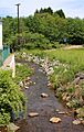
Watering Run looking upstream in its middle reaches
|
|
| Physical characteristics | |
| Main source | just northwest of the community of Rita in Wright Township, Luzerne County, Pennsylvania between 1,520 and 1,540 feet (460 and 470 m) |
| River mouth | Big Wapwallopen Creek on the border between Wright Township, Luzerne County, Pennsylvania and Rice Township, Luzerne County, Pennsylvania 1,076 ft (328 m) 41°06′56″N 75°57′27″W / 41.1156°N 75.9576°W |
| Length | 4.2 mi (6.8 km) |
| Basin features | |
| Progression | Big Wapwallopen Creek → Susquehanna River → Chesapeake Bay |
| Tributaries |
|
Watering Run is a small stream, or tributary, located in Luzerne County, Pennsylvania, in the United States. It flows into a larger stream called Big Wapwallopen Creek. Watering Run is about 4.2 miles (6.8 km) long and flows through an area known as Wright Township. The land area that drains into this stream, called its watershed, covers about 3.87 square miles (10.0 km2).
The soil around Watering Run includes different types like Morris Silt Loam and Oquaga Silt Loam. This stream is special because it's a "Coldwater Fishery," which means its waters are cold enough for certain types of fish, like trout, to live and thrive. Watering Run also experienced a flood in 1972.
Contents
Where Does Watering Run Flow?

Watering Run starts in Wright Township, just a bit northwest of a small community called Rita. From there, it flows generally towards the west.
As it travels, the stream changes direction a few times. It receives water from two smaller, unnamed streams that join it from its right side. It also flows under Pennsylvania Route 309, a major road. The stream then passes by a place called Little Nescopeck Mountain and goes through the community of Albert.
Finally, after flowing west for nearly a mile, Watering Run meets and joins Big Wapwallopen Creek. This meeting point is right on the border between Wright Township and Rice Township. Watering Run joins Big Wapwallopen Creek about 8.46 miles (13.62 km) before Big Wapwallopen Creek reaches its own end.
Understanding Watering Run's Water Flow
The amount of water flowing in Watering Run can change a lot, especially during heavy rains. When we talk about "peak annual discharge," we mean the highest amount of water that flows in the stream in a year.
For example, at the mouth of Watering Run, there's a 10% chance each year that the water flow will reach 480 cubic feet per second. This means that, on average, once every ten years, the stream could get that full. There's also a smaller chance (0.2%) that it could reach a very high flow of 1,450 cubic feet per second. This kind of event is much rarer.
Scientists have also tested the water in Watering Run. In 2003, a water sample showed no harmful chemicals called volatile organic compounds. However, more than twenty of these compounds have been found in the surface water of the larger area around the stream.
The Land and Rocks Around Watering Run
The land around Watering Run is interesting. The stream's mouth (where it ends) is about 1,076 feet (328 m) above sea level. Its source (where it begins) is much higher, between 1,520 and 1,540 feet (460 and 470 m) above sea level. This difference in height helps the water flow downhill.
Watering Run is surrounded by ridges, which are long, narrow hills. There are also many natural surface drainage features nearby, which help guide rainwater into the stream.
The main type of soil found along Watering Run is called Morris Silt Loam. This soil doesn't drain water very well. It formed from glacial till, which is material left behind by ancient glaciers. This till contains pieces of shale, sandstone, and siltstone. Other soil types, like Oquaga and Lordstown Silt Loams, are also found in the stream's valley.
Watering Run's Watershed
The watershed of Watering Run is the entire area of land where all the rain and snowmelt eventually drain into this stream. This watershed covers an area of about 3.87 square miles (10.0 km2).
Both the beginning and the end of Watering Run are located within a map area called the Freeland United States Geological Survey quadrangle. However, the stream also flows through another map area known as the Wilkes-Barre West quadrangle.
Some businesses, like the Certainteed Corporation, have permits to release stormwater into Watering Run. Stormwater is rainwater that flows over land and can pick up pollutants. There are also eight industrial properties located within 0.25 miles (0.40 km) of the stream.
A Look Back at Watering Run's History
Watering Run was officially added to the Geographic Names Information System on August 2, 1979. This system keeps track of names and locations of places in the United States.
Long ago, in the early 1900s, there were plans to build a bridge over Watering Run. The cost for this bridge was estimated to be around $200.
Watering Run experienced a significant flood in June 1972. During this flood, the stream's waters covered Alberdeen Road in the village of Albert with about 12 inches (30 cm) of water. This was the only time a major storm caused flooding in a developed part of Wright Township.
Wildlife and Biology in Watering Run
Watering Run is known as a Coldwater Fishery. This means its water stays cool enough for certain types of fish to live there.
One important fact about Watering Run is that wild trout naturally reproduce in the stream. This shows that the stream's environment is healthy enough to support these fish through their entire life cycle, from eggs to adult fish.
Images for kids
-
Watering Run looking upstream in its middle reaches
-
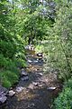
Watering Run looking downstream in its middle reaches at Albert
