
Wauchula, Florida facts for kids
Quick facts for kids
Wauchula, Florida
|
||
|---|---|---|
| City of Wauchula | ||

Wauchula Chamber of Commerce in 2010
|
||
|
||
| Motto(s):
"Building New Beginnings From Old Traditions"
"Cucumber Capital of the World" |
||

Location in Hardee County and the state of Florida
|
||
| Country | ||
| State | ||
| County | Hardee | |
| Incorporated | September 29, 1902 | |
| Government | ||
| • Type | Commission–Manager | |
| Area | ||
| • Total | 3.27 sq mi (8.46 km2) | |
| • Land | 3.27 sq mi (8.46 km2) | |
| • Water | 0.00 sq mi (0.00 km2) | |
| Elevation | 112 ft (34 m) | |
| Population
(2020)
|
||
| • Total | 4,900 | |
| • Density | 1,499.85/sq mi (579.13/km2) | |
| Time zone | UTC-5 (Eastern (EST)) | |
| • Summer (DST) | UTC-4 (EDT) | |
| ZIP code |
33873
|
|
| Area code(s) | 863 | |
| FIPS code | 12-75375 | |
| GNIS feature ID | 0292949 | |

Wauchula is a city in Hardee County, Florida, United States. It is also the county seat, which means it's where the main government offices for the county are located. In 2020, about 4,900 people lived there.
Wauchula is sometimes called the "cucumber capital of the world." However, growing citrus fruits like oranges has become more important for the area's farms in recent years. The city is also home to the historic downtown area and the Albert Carlton Estate.
Contents
Exploring Wauchula's Location and Surroundings
Wauchula is found in the north-central part of Hardee County. Its exact location is 27°32′46″N 81°48′52″W / 27.54611°N 81.81444°W.
U.S. Route 17 is a main road that goes through the city. This road leads north about 25 miles (40 km) to Bartow. It also goes south about 24 miles (39 km) to Arcadia. Nearby towns include Zolfo Springs, which is 4 miles (6.4 km) south, and Bowling Green, which is 6 miles (9.7 km) north.
The United States Census Bureau says that Wauchula covers an area of about 3.3 square miles (8.6 square kilometers). All of this area is land.
How Hurricane Charley Affected Wauchula
On August 13, 2004, a powerful storm called Hurricane Charley hit Wauchula. It caused a lot of damage, more than $750 million worth. Winds reached about 140 miles per hour (225 km/h), with stronger gusts.
After the hurricane, many parts of Wauchula had no clean water or no water at all for a week. Many areas also lost electricity for almost three weeks. Schools were closed for two weeks. The government declared the area a federal disaster area. This was because 85% of the buildings were either damaged or completely destroyed. For weeks after the storm, people had to follow a curfew from 8 PM to 7 AM.
Wauchula's Climate and Weather
The weather in Wauchula is known for hot, humid summers and warm winters. It has a humid subtropical climate. This means it gets a lot of rain, especially in the summer.
| Climate data for Wauchula, Florida, 1991–2020 normals, extremes 1933–present | |||||||||||||
|---|---|---|---|---|---|---|---|---|---|---|---|---|---|
| Month | Jan | Feb | Mar | Apr | May | Jun | Jul | Aug | Sep | Oct | Nov | Dec | Year |
| Record high °F (°C) | 90 (32) |
93 (34) |
94 (34) |
99 (37) |
104 (40) |
103 (39) |
102 (39) |
99 (37) |
99 (37) |
97 (36) |
92 (33) |
92 (33) |
104 (40) |
| Mean maximum °F (°C) | 83.9 (28.8) |
86.0 (30.0) |
87.1 (30.6) |
91.2 (32.9) |
94.2 (34.6) |
95.8 (35.4) |
95.6 (35.3) |
95.7 (35.4) |
94.3 (34.6) |
91.5 (33.1) |
87.2 (30.7) |
84.6 (29.2) |
96.9 (36.1) |
| Mean daily maximum °F (°C) | 72.7 (22.6) |
76.2 (24.6) |
79.6 (26.4) |
84.2 (29.0) |
88.7 (31.5) |
90.7 (32.6) |
91.8 (33.2) |
92.0 (33.3) |
90.1 (32.3) |
85.7 (29.8) |
79.5 (26.4) |
75.0 (23.9) |
83.8 (28.8) |
| Daily mean °F (°C) | 60.2 (15.7) |
62.9 (17.2) |
66.2 (19.0) |
71.0 (21.7) |
76.3 (24.6) |
80.5 (26.9) |
81.9 (27.7) |
82.3 (27.9) |
80.8 (27.1) |
75.3 (24.1) |
67.8 (19.9) |
63.0 (17.2) |
72.4 (22.4) |
| Mean daily minimum °F (°C) | 47.7 (8.7) |
49.6 (9.8) |
52.9 (11.6) |
57.7 (14.3) |
63.9 (17.7) |
70.3 (21.3) |
72.1 (22.3) |
72.7 (22.6) |
71.5 (21.9) |
64.9 (18.3) |
56.0 (13.3) |
51.0 (10.6) |
60.9 (16.1) |
| Mean minimum °F (°C) | 31.1 (−0.5) |
34.0 (1.1) |
37.9 (3.3) |
45.2 (7.3) |
54.4 (12.4) |
65.2 (18.4) |
68.6 (20.3) |
69.1 (20.6) |
66.1 (18.9) |
50.2 (10.1) |
41.4 (5.2) |
34.8 (1.6) |
29.5 (−1.4) |
| Record low °F (°C) | 20 (−7) |
24 (−4) |
23 (−5) |
34 (1) |
40 (4) |
51 (11) |
61 (16) |
61 (16) |
55 (13) |
37 (3) |
24 (−4) |
21 (−6) |
20 (−7) |
| Average precipitation inches (mm) | 2.29 (58) |
2.18 (55) |
2.99 (76) |
2.92 (74) |
3.51 (89) |
8.46 (215) |
7.69 (195) |
8.46 (215) |
6.32 (161) |
3.09 (78) |
1.96 (50) |
2.13 (54) |
52.00 (1,321) |
| Average precipitation days (≥ 0.01 in) | 4.9 | 4.1 | 4.2 | 4.3 | 5.8 | 13.4 | 13.1 | 13.9 | 11.3 | 5.8 | 3.9 | 4.5 | 89.2 |
| Source: NOAA | |||||||||||||
Who Lives in Wauchula? A Look at the Population
| Historical population | |||
|---|---|---|---|
| Census | Pop. | %± | |
| 1910 | 1,099 | — | |
| 1920 | 2,081 | 89.4% | |
| 1930 | 2,574 | 23.7% | |
| 1940 | 2,710 | 5.3% | |
| 1950 | 2,872 | 6.0% | |
| 1960 | 3,411 | 18.8% | |
| 1970 | 3,007 | −11.8% | |
| 1980 | 3,296 | 9.6% | |
| 1990 | 3,253 | −1.3% | |
| 2000 | 4,368 | 34.3% | |
| 2010 | 5,001 | 14.5% | |
| 2020 | 4,900 | −2.0% | |
| U.S. Decennial Census | |||
Population Changes from 2010 to 2020
| Race | Pop 2010 | Pop 2020 | % 2010 | % 2020 |
|---|---|---|---|---|
| White (NH) | 2,179 | 2,008 | 43.57% | 40.98% |
| Black or African American (NH) | 281 | 358 | 5.62% | 7.31% |
| Native American or Alaska Native (NH) | 17 | 4 | 0.34% | 0.08% |
| Asian (NH) | 49 | 41 | 0.98% | 0.84% |
| Pacific Islander or Native Hawaiian (NH) | 1 | 2 | 0.02% | 0.04% |
| Some other race (NH) | 4 | 5 | 0.08% | 0.10% |
| Two or more races/Multiracial (NH) | 42 | 97 | 0.84% | 1.98% |
| Hispanic or Latino (any race) | 2,428 | 2,385 | 48.55% | 48.67% |
| Total | 5,001 | 4,900 | 100.00% | 100.00% |
In 2020, the 2020 United States census counted 4,900 people living in Wauchula. There were 1,630 households and 1,072 families.
Back in 2010, the 2010 United States census showed 5,001 people. At that time, there were 1,574 households and 1,035 families in the city.
Important Places and Services in Wauchula
Wauchula has several important places that help the community.
The Wauchula Municipal Airport is an airport for public use. It is located about 3 miles (5 km) southwest of the city's main business area.
The Center for Great Apes is a special place. It is a permanent home for orangutans and chimpanzees that have been rescued.
The only hospital in Wauchula is AdventHealth Wauchula. It provides healthcare services to the people living in the city and nearby areas.
Famous People From Wauchula
Many interesting people have come from Wauchula, including:
- Doyle E. Carlton (1885–1972), who was the 25th governor of Florida.
- Tom McEwen (1923–2011), a well-known sportswriter.
- B. J. McLeod (born 1983), a professional NASCAR driver.
- Zeke Mowatt (born 1961), an NFL football player who won Super Bowl XXI.
Images for kids
-
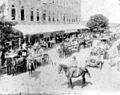
Confederate Memorial Day parade on Main Street, 1912
-
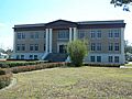
Hardee County Courthouse
.jpg)

See also
 In Spanish: Wauchula para niños
