
Waupaca, Wisconsin facts for kids
Quick facts for kids
Waupaca, Wisconsin
|
|
|---|---|
|
City
|
|

Waupaca City Hall/Library Building
|
|

Location of Waupaca in Waupaca County, Wisconsin.
|
|

Waupaca, Wisconsin
Location in Wisconsin

Waupaca, Wisconsin
Location in the United States
|
|
| Country | United States |
| State | Wisconsin |
| County | Waupaca |
| Area | |
| • Total | 8.21 sq mi (21.27 km2) |
| • Land | 7.92 sq mi (20.51 km2) |
| • Water | 0.29 sq mi (0.75 km2) |
| Population
(2020)
|
|
| • Total | 6,282 |
| • Density | 793.2/sq mi (306.3/km2) |
| Time zone | UTC-6 (Central (CST)) |
| • Summer (DST) | UTC-5 (CDT) |
| ZIP code |
54981
|
| Area code(s) | 715 & 534 |
| FIPS code | 55-84375 |
| Website | www.cityofwaupaca.org |


Waupaca (pronounced wuh-PAK-uh) is a city in Wisconsin, a state in the United States. It is the main city, or county seat, of Waupaca County. In 2020, about 6,282 people lived here.
The city of Waupaca is mostly located within the Town of Waupaca. However, it is a separate government from the town. A small part of the city also reaches into the Town of Farmington to the west. There's even a small piece of the city located in the Town of Lind to the south.
Contents
Waupaca's Story: A Look at Its History
Early People and the Menominee Tribe
Long before European settlers arrived, Native American people known as mound builders lived in the Waupaca area. These groups built large earth mounds, some of which were very old. At one point, there were 72 of these mounds in the area.
The name "Waupaca" comes from the Menominee word Wāpahkoh. This word means "Place of Tomorrow Seen Clearly." For over 10,000 years, the Menominee tribe lived on a large area of land, including where Waupaca is today. They had big villages near Taylor and Otter Lakes and set up camps along the waterfalls of the Waupaca River.
Over time, the Menominee tribe gave up their lands to the United States through several agreements. The last agreement, signed in 1848, included the land that would become Waupaca.
European Settlers Arrive
In 1849, the first white settlers came to Waupaca. These five men from Vermont were looking for the waterfalls. They set up camp near what is now North Main Street. Their goal was to use the power of the falls to build a new community.
By 1852, a post office was opened, and the settlement was officially named Waupaca. Waupaca became a village on May 4, 1857. Later, on March 5, 1875, it officially became a city.
Since the 1960s, Waupaca has grown bigger. It has added more land and people by taking in nearby areas.
Where is Waupaca? Geography and Climate
Waupaca's Location
Waupaca is located at 44°21′17″N 89°4′54″W / 44.35472°N 89.08167°W.
The United States Census Bureau says that the city covers a total area of about 8.21 square miles (21.27 square kilometers). Most of this area, about 7.92 square miles (20.51 square kilometers), is land. The rest, about 0.29 square miles (0.75 square kilometers), is water.
Waupaca's Weather
| Climate data for Waupaca, Wisconsin, 1991–2020 normals, extremes 1896–present | |||||||||||||
|---|---|---|---|---|---|---|---|---|---|---|---|---|---|
| Month | Jan | Feb | Mar | Apr | May | Jun | Jul | Aug | Sep | Oct | Nov | Dec | Year |
| Record high °F (°C) | 60 (16) |
65 (18) |
84 (29) |
92 (33) |
102 (39) |
103 (39) |
106 (41) |
105 (41) |
99 (37) |
90 (32) |
77 (25) |
64 (18) |
106 (41) |
| Mean maximum °F (°C) | 44.3 (6.8) |
49.0 (9.4) |
64.4 (18.0) |
78.1 (25.6) |
86.5 (30.3) |
91.1 (32.8) |
92.4 (33.6) |
90.6 (32.6) |
85.9 (29.9) |
78.1 (25.6) |
62.0 (16.7) |
47.6 (8.7) |
94.6 (34.8) |
| Mean daily maximum °F (°C) | 25.1 (−3.8) |
29.2 (−1.6) |
41.3 (5.2) |
55.1 (12.8) |
68.2 (20.1) |
77.4 (25.2) |
82.0 (27.8) |
79.5 (26.4) |
71.7 (22.1) |
57.9 (14.4) |
43.1 (6.2) |
30.2 (−1.0) |
55.1 (12.8) |
| Daily mean °F (°C) | 16.3 (−8.7) |
19.8 (−6.8) |
31.3 (−0.4) |
43.9 (6.6) |
56.6 (13.7) |
66.1 (18.9) |
70.4 (21.3) |
68.4 (20.2) |
60.3 (15.7) |
47.4 (8.6) |
34.4 (1.3) |
22.4 (−5.3) |
44.8 (7.1) |
| Mean daily minimum °F (°C) | 7.6 (−13.6) |
10.4 (−12.0) |
21.3 (−5.9) |
32.7 (0.4) |
44.9 (7.2) |
54.7 (12.6) |
58.8 (14.9) |
57.2 (14.0) |
48.9 (9.4) |
36.9 (2.7) |
25.8 (−3.4) |
14.5 (−9.7) |
34.5 (1.4) |
| Mean minimum °F (°C) | −12.6 (−24.8) |
−9.1 (−22.8) |
0.2 (−17.7) |
19.6 (−6.9) |
30.8 (−0.7) |
41.8 (5.4) |
48.9 (9.4) |
46.1 (7.8) |
34.8 (1.6) |
24.7 (−4.1) |
11.4 (−11.4) |
−5.8 (−21.0) |
−16.4 (−26.9) |
| Record low °F (°C) | −38 (−39) |
−41 (−41) |
−26 (−32) |
6 (−14) |
17 (−8) |
30 (−1) |
40 (4) |
32 (0) |
18 (−8) |
6 (−14) |
−13 (−25) |
−28 (−33) |
−41 (−41) |
| Average precipitation inches (mm) | 1.41 (36) |
1.11 (28) |
1.94 (49) |
3.44 (87) |
4.07 (103) |
4.49 (114) |
3.77 (96) |
3.86 (98) |
3.34 (85) |
2.61 (66) |
2.06 (52) |
1.71 (43) |
33.81 (857) |
| Average snowfall inches (cm) | 10.9 (28) |
11.9 (30) |
7.0 (18) |
4.7 (12) |
0.1 (0.25) |
0.0 (0.0) |
0.0 (0.0) |
0.0 (0.0) |
0.0 (0.0) |
0.3 (0.76) |
2.1 (5.3) |
12.3 (31) |
49.3 (125.31) |
| Average precipitation days (≥ 0.01 in) | 8.6 | 6.9 | 7.3 | 10.3 | 11.5 | 11.1 | 9.5 | 9.5 | 9.7 | 9.2 | 7.4 | 8.4 | 109.4 |
| Average snowy days (≥ 0.1 in) | 7.1 | 5.3 | 3.5 | 2.0 | 0.1 | 0.0 | 0.0 | 0.0 | 0.0 | 0.2 | 1.8 | 5.7 | 25.7 |
| Source 1: NOAA | |||||||||||||
| Source 2: National Weather Service | |||||||||||||
Getting Around: Transportation in Waupaca
Waupaca has several important roads that connect it to other towns and cities.
|
|
U.S. 10 goes east to Appleton and west to Stevens Point. |
|
|
WIS 22 travels north to Clintonville and south to Wild Rose. |
|
|
WIS 49 goes north to Iola. Southbound, it shares the road with US 10 and goes to Berlin. |
|
|
WIS 54 travels east to New London and west to Wisconsin Rapids, Wisconsin. |
From 1899 to 1926, Waupaca also had a streetcar service. This was run by the Waupaca Electric Light and Railway Company.
Waupaca Municipal Airport
- KPCZ - Waupaca Municipal Airport is the local airport for the city.
Who Lives in Waupaca? Demographics
| Historical population | |||
|---|---|---|---|
| Census | Pop. | %± | |
| 1880 | 1,392 | — | |
| 1890 | 2,127 | 52.8% | |
| 1900 | 2,912 | 36.9% | |
| 1910 | 2,789 | −4.2% | |
| 1920 | 2,839 | 1.8% | |
| 1930 | 3,131 | 10.3% | |
| 1940 | 3,458 | 10.4% | |
| 1950 | 3,921 | 13.4% | |
| 1960 | 3,984 | 1.6% | |
| 1970 | 4,342 | 9.0% | |
| 1980 | 4,472 | 3.0% | |
| 1990 | 4,957 | 10.8% | |
| 2000 | 5,676 | 14.5% | |
| 2010 | 6,069 | 6.9% | |
| 2020 | 6,282 | 3.5% | |
| U.S. Decennial Census | |||
2020 Census Information
In 2020, Waupaca had a population of 6,282 people. This means there were about 793 people living in each square mile. There were 3,066 homes in the city.
Most of the people in Waupaca were White (91.3%). Other groups included Black or African American (1.1%), Asian (1.0%), and Native American (0.6%). About 4.0% of the population was Hispanic or Latino.
2010 Census Information
In 2010, there were 6,069 people living in Waupaca. There were 2,702 households, which are groups of people living together in one home.
About 25.9% of these households had children under 18. Many households (34.9%) were married couples. About 10.9% were homes where a mother lived with her children but no husband.
The average age of people in Waupaca was 40.1 years old. About 22.1% of residents were under 18. About 20.1% were 65 years old or older. The city had slightly more females (52.5%) than males (47.5%).
Business and Jobs in Waupaca

Waupaca Foundry is the biggest employer in the city. It has over 1,500 workers across three different locations in or near Waupaca. Most of these employees live close to the city.
Another company, Gusmer Enterprises, Inc., has a factory in Waupaca. They make products for the food, drink, industrial, and medicine industries.
Famous People from Waupaca
Many notable people have come from Waupaca. Here are a few:
- Edward E. Browne, a United States Representative
- Clarence Ekstrom, a Vice Admiral in the U.S. Navy
- Brock Jensen, an NFL quarterback
- Greg Johnson, a curler
- Brian Rafalski, an NHL defensemen
- Clay Perry, a writer who created the word "spelunker" for someone who explores caves.
Waupaca's Sister Cities
Waupaca has two sister cities. These are cities in different countries that form a special bond to promote cultural exchange and understanding.
 Hochheim am Main, Hesse, Germany
 Mitoyo, Kagawa Prefecture, Japan
Images for kids
-
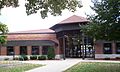
The Waupaca Public Library
-
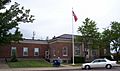
The Waupaca Post Office, a historic building
-
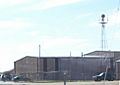
The Waupaca Municipal Airport
-
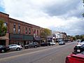
A part of the historic Main Street area
-
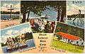
An old postcard of Pine Lake Camp (around 1930–1945)


.jpg)
See also
 In Spanish: Waupaca (Wisconsin) para niños
