Wayne, West Virginia facts for kids
Quick facts for kids
Wayne, West Virginia
|
||
|---|---|---|

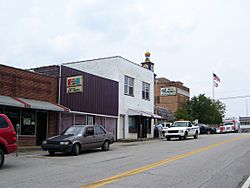
Hendrick Street in Wayne
|
||
|
||

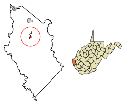
Location of Wayne in Wayne County, West Virginia.
|
||
| Country | United States | |
| State | West Virginia | |
| County | Wayne | |
| Trout's Hill (post office was Wayne Court House) | 1842 | |
| Named for | Anthony Wayne | |
| Area | ||
| • Total | 1.18 sq mi (3.06 km2) | |
| • Land | 1.18 sq mi (3.06 km2) | |
| • Water | 0.00 sq mi (0.00 km2) | |
| Elevation | 696 ft (212 m) | |
| Population
(2020)
|
||
| • Total | 1,441 | |
| • Estimate
(2021)
|
1,423 | |
| • Density | 1,335.59/sq mi (515.66/km2) | |
| Time zone | UTC-5 (Eastern (EST)) | |
| • Summer (DST) | UTC-4 (EDT) | |
| ZIP code |
25570
|
|
| Area code(s) | 304 | |
| FIPS code | 54-84940 | |
| GNIS feature ID | 1548850 | |
Wayne is a town in West Virginia, United States. It is the main town and the county seat of Wayne County, West Virginia. In 2020, about 1,441 people lived there. Wayne is also part of the larger Huntington–Ashland metropolitan area.
Contents
Town Name History
Wayne was created in 1842. This happened when Wayne County was also formed. The county was named after a famous general, General "Mad Anthony" Wayne.
The town was first called "Trout's Hill." This name came from Abraham Trout. He gave the land where the county's courthouse was built. A post office called Wayne Courthouse opened in 1842. For many years, people called the town both Trout's Hill and Wayne Courthouse.
In 1860 and again in 1882, the town was officially named Fairview. But most people still called it Wayne Courthouse. In 1882, about 157 people lived there.
In 1890, a railroad called the Norfolk & Western was built. The railroad put "Wayne" on its train schedule. This name became very popular. The town officially changed its name to Wayne in 1911.
| 1st Name | 2nd Name | 3rd Name | 4th Name |
|---|---|---|---|
| Trout's Hill | Wayne Court House | Fairview | Wayne |
| 1842-ca 1860 | 1842–1892 | 1860–1892 | 1892–present |
Wayne's Early History
People started settling near what is now Wayne in the early 1800s. In 1828, Abraham Trout started a mill. It was located where the town stands today, by a waterfall on Twelve Pole Creek. Later, he built a dam for his mill.
Forming Wayne County
By the 1830s, more people were moving to western Cabell County. This made it necessary to create a new county. In 1840, some people tried to create a county near the Big Sandy River. Their plan did not work.
A year later, people from the Twelve Pole area worked to create a new county. They wanted the main town to be near the forks of Twelve Pole Creek. Their efforts were successful. The new county was formed on January 18, 1842. It was named after General Anthony Wayne.
The main town for the county was built on Abraham Trout's farm. He gave land for the town square and government buildings. Then, he started selling other land around the square. The town became known as Trout's Hill and Wayne Courthouse.
Civil War Times
In 1860, the town was officially named Fairview. But this name was not very popular. Most people still used the older names. Around 1860, a group of soldiers called the Fairview Rifles was formed in Trout's Hill. They later joined the 8th Virginia Cavalry during the war.
When the Civil War started, there was a lot of excitement in Trout's Hill. The Virginia flag replaced the American flag. In August 1861, there was a three-day fight in the streets of Trout's Hill. Union soldiers from Ceredo tried to get the county's official records.
The Union soldiers camped in the courthouse. Local Rebel fighters tried to make them leave. After getting the records, the Union soldiers went back to Ceredo. Union forces launched several more attacks on Trout's Hill during the war.
After the War and Growth
After the Civil War, Trout's Hill was important. It was at the entrance to large areas of timber and coal in southern Wayne County. The Norfolk & Western Railway built a train line through the town in 1890. They also built a train station.
The railroad heard the name Wayne Courthouse. They shortened it to "Wayne." This name has been used ever since. The name change became official in 1911.
Courthouse Challenges
From the 1890s to the 1920s, the town of Wayne had to fight to keep its courthouse. Other towns like Ceredo, Kenova, and Westmoreland wanted the county seat moved to their locations.
During these "courthouse wars," many buildings in Wayne were burned. This included the courthouse in 1921. In 1905, a fire destroyed much of the town. This happened during one of the biggest fights over where the courthouse should be.
Geography and Climate
Wayne is located at 38°13′42″N 82°26′26″W / 38.22833°N 82.44056°W. It sits along Twelvepole Creek. The town is about 707 feet (215 meters) above sea level.
The United States Census Bureau says the town covers about 0.72 square miles (1.86 square kilometers). All of this area is land.
Climate in Wayne
The weather in Wayne has hot, humid summers. Winters are usually mild to cool. According to the Köppen Climate Classification system, Wayne has a humid subtropical climate. This means it has warm temperatures and plenty of rain throughout the year.
Holy Cross Monastery
Holy Cross Monastery is a ROCOR monastery. It is located about 4.7 miles east of Wayne. The monastery moved to the area in 2000.
Population Information
| Historical population | |||
|---|---|---|---|
| Census | Pop. | %± | |
| 1880 | 157 | — | |
| 1890 | 361 | 129.9% | |
| 1900 | 407 | 12.7% | |
| 1910 | 384 | −5.7% | |
| 1920 | 446 | 16.1% | |
| 1930 | 675 | 51.3% | |
| 1940 | 801 | 18.7% | |
| 1950 | 1,257 | 56.9% | |
| 1960 | 1,274 | 1.4% | |
| 1970 | 1,385 | 8.7% | |
| 1980 | 1,495 | 7.9% | |
| 1990 | 1,128 | −24.5% | |
| 2000 | 1,105 | −2.0% | |
| 2010 | 1,413 | 27.9% | |
| 2020 | 1,441 | 2.0% | |
| 2021 (est.) | 1,423 | 0.7% | |
| U.S. Decennial Census | |||
2010 Census Details
In 2010, there were 1,413 people living in Wayne. There were 635 households and 374 families. The town had about 1,962.5 people per square mile. There were 693 homes, with about 962.5 homes per square mile.
Most of the people in Wayne were White (98.2%). A small number were African American (0.1%), Native American (0.4%), or Asian (0.4%). About 0.8% of people were from two or more races. Less than 1% of the population was Hispanic or Latino.
About 29.4% of households had children under 18 living with them. About 37.2% were married couples. The average household had 2.23 people. The average family had 2.91 people.
The average age in Wayne was 38.8 years old. About 24.2% of residents were under 18. About 17.5% were 65 or older. There were more females (54.3%) than males (45.7%) in the town.
See also
 In Spanish: Wayne (Virginia Occidental) para niños


