
Weatherly, Pennsylvania facts for kids
Quick facts for kids
Weatherly, Pennsylvania
|
|
|---|---|
|
Borough
|
|

The former Mrs. C.M. Schwab School, built in 1901
|
|

Location of Weatherly in Carbon County, Pennsylvania.
|
|

Weatherly, Pennsylvania
Location in Pennsylvania

Weatherly, Pennsylvania
Location in the United States
|
|
| Country | United States |
| State | Pennsylvania |
| County | Carbon |
| Area | |
| • Total | 2.98 sq mi (7.72 km2) |
| • Land | 2.98 sq mi (7.72 km2) |
| • Water | 0.00 sq mi (0.00 km2) |
| Elevation | 1,094 ft (333 m) |
| Population
(2020)
|
|
| • Total | 2,541 |
| • Density | 852.97/sq mi (329.32/km2) |
| Time zone | UTC-5 (EST) |
| • Summer (DST) | UTC-4 (EDT) |
| ZIP Code |
18255
|
| Area code(s) | 570 and 272 |
Weatherly is a small town, also called a borough, in Carbon County, Pennsylvania, United States. It's part of Northeastern Pennsylvania. Weatherly is about 12 miles (19 km) northwest of Jim Thorpe and 28 miles (45 km) south of Wilkes-Barre.
In 2010, about 2,525 people lived here. By 2020, the population grew slightly to 2,541.
Contents
A Look Back: Weatherly's Story
Weatherly was first known as "Black Creek." In 1848, its name changed to "Weatherly." This happened because a clock-maker named David Weatherly, who also worked for the Beaver Meadow Railroad, made a deal. He promised to build a clock for the town if they renamed it "Weatherly."
The town agreed and changed its name. However, David Weatherly became sick with cancer and sadly passed away in Philadelphia before he could build the clock. Later, Charles and Eurana Schwab paid for a clock to be built. This clock was placed in a tower on top of the town's school. Even though David Weatherly didn't build the clock, the town kept the name "Weatherly."
In the early 1900s, Weatherly was a busy place. It had factories that made silk, metal parts (foundries), candy, and even cigars! In 1900, 2,471 people lived there, and by 1910, the population was 2,501.
Where is Weatherly?
Weatherly is located in the northwestern part of Carbon County. It sits at an elevation of about 1,100 feet (335 meters) above sea level. The town is nestled in a region called the Ridge-and-Valley Province of the Appalachian Mountains. It's surrounded by mountains, with Spring Mountain and Round Head Mountain to the north and Broad Mountain to the south.
According to the U.S. Census Bureau, Weatherly covers a total area of about 2.98 square miles (7.72 square kilometers). All of this area is land, with no water.
Who Lives in Weatherly?
| Historical population | |||
|---|---|---|---|
| Census | Pop. | %± | |
| 1870 | 1,076 | — | |
| 1880 | 1,977 | 83.7% | |
| 1890 | 2,961 | 49.8% | |
| 1900 | 2,471 | −16.5% | |
| 1910 | 2,501 | 1.2% | |
| 1920 | 2,356 | −5.8% | |
| 1930 | 2,531 | 7.4% | |
| 1940 | 2,754 | 8.8% | |
| 1950 | 2,622 | −4.8% | |
| 1960 | 2,591 | −1.2% | |
| 1970 | 2,554 | −1.4% | |
| 1980 | 2,891 | 13.2% | |
| 1990 | 2,640 | −8.7% | |
| 2000 | 2,612 | −1.1% | |
| 2010 | 2,525 | −3.3% | |
| 2020 | 2,541 | 0.6% | |
| U.S. Decennial Census | |||
In 2000, there were 2,612 people living in Weatherly. These people lived in 931 households, with 679 of them being families. The town had about 867 people per square mile (335 people per square kilometer).
Most of the people in Weatherly are White (about 98%). A small number of residents are African American, Asian, Pacific Islander, or from other backgrounds. About 0.69% of the population identified as Hispanic or Latino.
Many families in Weatherly have roots from different parts of the world. The most common backgrounds include Italian (25.2%), Polish (15.8%), German (12.4%), Irish (10.9%), and Slovak (5.5%).
About 33% of households had children under 18 living with them. Most households (58%) were married couples living together. The average household had about 2.57 people, and the average family had about 3.03 people.
The median age in Weatherly in 2000 was 42 years old. This means half the population was younger than 42, and half was older. About 23% of the population was under 18, and about 24% was 65 or older.
Getting Around Weatherly
As of 2007, Weatherly had about 14.58 miles (23.46 km) of public roads. The Pennsylvania Department of Transportation (PennDOT) takes care of about 4.33 miles (6.97 km) of these roads, while the borough itself maintains the other 10.25 miles (16.50 km).
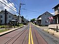
There are no major numbered highways that go directly through Weatherly. Some of the main streets in the borough include Hudsondale Street, Main Street, Plane Street, and Hill Street. The closest numbered highway is Pennsylvania Route 93.
Schools in Weatherly
The Weatherly Area School District serves about 800 students. The younger students attend elementary and middle school in one building. The high school is located right across the street from this building.
The current Weatherly Area High School building has been used since 1991. Before that, for 90 years, students went to the Mrs. C.M. Schwab school.
Famous People from Weatherly
Weatherly has been home to several notable people:
- Roland W. Brown – A scientist who studied plants (botanist) and rocks (geologist).
- Justin McCarthy – A talented painter.
- Elmer Warner – A person involved in politics.
- Thomas Jerome Welsh – A bishop in the Roman Catholic Church from 1974 to 1997.
Images for kids
-
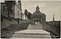
Presbyterian church, Schwab School and Civil War Memorial on an old postcard
-
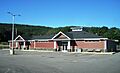
Borough hall
-
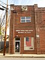
Post Office
-
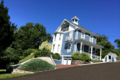
Late 1800's House in Weatherly, PA
-
Hudsondale Street in Summit Hill

,_Sept._2023.jpg)


See also
 In Spanish: Weatherly para niños
