West Vero Corridor, Florida facts for kids
Quick facts for kids
West Vero Corridor, Florida
|
|
|---|---|

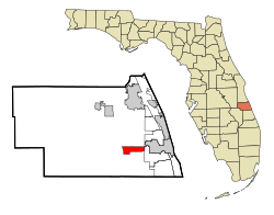
Location in Indian River County and the state of Florida
|
|
| Country | |
| State | |
| County | Indian River |
| Area | |
| • Total | 5.96 sq mi (15.43 km2) |
| • Land | 5.86 sq mi (15.17 km2) |
| • Water | 0.10 sq mi (0.26 km2) |
| Elevation | 20 ft (6 m) |
| Population
(2020)
|
|
| • Total | 10,039 |
| • Density | 1,714.02/sq mi (661.79/km2) |
| Time zone | UTC-5 (Eastern (EST)) |
| • Summer (DST) | UTC-4 (EDT) |
| ZIP code |
32966
|
| Area code(s) | 772 |
| FIPS code | 12-76937 |
| GNIS feature ID | 1853305 |
West Vero Corridor is a special kind of community in Indian River County, Florida, United States. It's called a census-designated place (CDP). This means it's an area that the government counts for population, but it's not officially a city or town with its own local government. In 2020, about 10,039 people lived there. West Vero Corridor is part of the larger Sebastian–Vero Beach area.
Contents
Exploring West Vero Corridor's Location
West Vero Corridor is located in the southeastern part of Indian River County. You can find it around 27.64 degrees North and 80.50 degrees West. The area stretches about 4 miles (6.4 km) along both sides of Florida State Road 60. This road is west of the city of Vero Beach.
Where is West Vero Corridor?
To the east, West Vero Corridor borders another CDP called Vero Beach South. To the west, it meets Interstate 95, a major highway. The center of Vero Beach is only about 3 miles (4.8 km) east of West Vero Corridor if you take State Road 60. Interstate 95 can take you north about 33 miles (53 km) to Melbourne. If you go south on I-95, it's about 16 miles (26 km) to Fort Pierce.
Land and Water Area
The United States Census Bureau says that West Vero Corridor covers a total area of about 5.96 square miles (15.43 square kilometers). Most of this area is land, about 5.86 square miles (15.17 square kilometers). A small part, about 0.10 square miles (0.26 square kilometers), is water. This means about 1.71% of the area is water.
A Look Back at West Vero Corridor's History
Before European settlers arrived, the land that is now West Vero Corridor was home to several Native American tribes. These included the Ais and the Seminoles. Like most native peoples, they lived off the land. They used resources from the nearby Indian River and the surrounding wilderness.
Early European Influence
In the 1500s, Spanish explorers came to Florida. They started some settlements along the coast. This brought European ways to the region. However, West Vero Corridor itself didn't see many settlers until the late 1800s and early 1900s.
Farming and Growth
At first, the area was mainly used for raising cattle and for farming. Citrus farming, like growing oranges and grapefruits, became a very important business here.
Modern Development
Between the 1980s and the early 2000s, West Vero Corridor grew a lot. New highways and other important buildings were built. This made it easier for more people and businesses to move into the area. Popular places like the Indian River Mall and the Vero Beach Outlets were built during this time.
Understanding West Vero Corridor's Population
The population of West Vero Corridor has changed over the years. In 2000, there were 7,695 people. By 2010, the number was 7,138. In the most recent 2020 census, the population grew to 10,039 people.
| Historical population | |||
|---|---|---|---|
| Census | Pop. | %± | |
| 2000 | 7,695 | — | |
| 2010 | 7,138 | −7.2% | |
| 2020 | 10,039 | 40.6% | |
| U.S. Decennial Census | |||
Who Lives in West Vero Corridor?
The 2020 census showed that 10,039 people lived in 5,638 homes. On average, there were about 1,714 people per square mile. There were also 6,685 housing units, which are homes or apartments.
The people living in West Vero Corridor are of different ages. About 9.1% of the population was under 20 years old. About 2.5% were between 18 and 24. People aged 25 to 44 made up 10.8%. The largest group, 53.6%, were 65 years old or older. The average age was 67 years. About 46.2% of the people were male, and 53.8% were female.
Household Income
The average income for a household in West Vero Corridor was $51,998. The average income per person was $36,383. About 8.5% of the people lived below the poverty line.
See also
 In Spanish: West Vero Corridor para niños
 | Janet Taylor Pickett |
 | Synthia Saint James |
 | Howardena Pindell |
 | Faith Ringgold |

