Whittier, Alaska facts for kids
Quick facts for kids
Whittier, Alaska
|
|||||
|---|---|---|---|---|---|
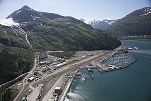
Whittier in July 2006
|
|||||
|
|||||
| Nickname(s):
The Town Under One Roof
|
|||||
| Country | United States | ||||
| State | Alaska | ||||
| Census Area | Chugach | ||||
| Incorporated | July 15, 1969 | ||||
| Government | |||||
| • Type | Council–manager | ||||
| Area | |||||
| • Total | 19.64 sq mi (50.86 km2) | ||||
| • Land | 12.25 sq mi (31.73 km2) | ||||
| • Water | 7.39 sq mi (19.13 km2) | ||||
| Elevation | 43 ft (13 m) | ||||
| Population
(2020)
|
|||||
| • Total | 272 | ||||
| • Density | 22.20/sq mi (8.57/km2) | ||||
| Time zone | UTC−09:00 (Alaska (AKST)) | ||||
| • Summer (DST) | UTC−08:00 (AKDT) | ||||
| ZIP Code |
99693
|
||||
| Area code | 907 | ||||
| FIPS code | 02-84510 | ||||
| GNIS feature ID | 1415757 | ||||
Whittier is a small city in Alaska, a state in the United States. It is located at the end of Passage Canal, about 58 miles (93 km) southeast of Anchorage. Whittier is part of the Chugach Census Area. It is also an important port for the Alaska Marine Highway, which is a ferry system. In 2020, 272 people lived in Whittier.
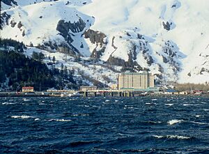
Whittier is known for its very wet weather, getting about 197 inches (500 cm) of rain and snow each year. What makes Whittier really special is that almost everyone who lives there lives in one large building called the Begich Towers Condominium. This is why it's often called "the town under one roof."
Contents
History of Whittier
The area where Whittier is located was once a travel route for the Chugach people. They were a native group from Prince William Sound. Later, explorers from Russia and America used this route. Miners also passed through during the Klondike Gold Rush to find gold.
The nearby Whittier Glacier was named in 1915 after an American poet, John Greenleaf Whittier. The town later took the same name.
Whittier During World War II
During World War II, the United States Army built a military base near Whittier Glacier. This base was called Camp Sullivan. It had a port and a railroad. The railroad line to Camp Sullivan was finished in 1943. This port became the main entry point for American soldiers going into Alaska.
Buildings of Whittier
The two largest buildings in Whittier were built after World War II. The 14-story Hodge Building, now called Begich Towers, was finished in 1957. It has 150 apartments. Families of soldiers and government workers lived there. The local school was connected to the building by a tunnel. This allowed students to get to school safely in bad weather. The building was named after Colonel Walter William Hodge, an engineer.
The other big building, the Buckner Building, was finished in 1953. It was also called a "city under one roof." The Buckner Building was later left empty. Both the Buckner and Begich Towers were once the biggest buildings in Alaska. Today, the Begich Towers is a condominium. Most of Whittier's residents live there, along with a smaller building called Whittier Manor.
The port in Whittier was an active Army base until 1960. In 1962, the U.S. Army Corps of Engineers built a station to handle oil products. They also built a 62-mile (100 km) pipeline to Anchorage from Whittier.
The 1964 Earthquake
On March 27, 1964, Whittier was hit by a huge earthquake. It is known as the Good Friday earthquake. This earthquake caused over $10 million in damage to Whittier. It was the largest earthquake ever recorded in the U.S. It measured 9.2 on the moment magnitude scale. The earthquake also caused tsunamis along the West Coast of the U.S. In Whittier, the tsunami wave was 13 meters (43 feet) high. It sadly killed 13 people.
Whittier Today
Whittier became an official city in 1969. It later became a popular stop for cruise ships. Local boats and smaller cruise ships use its port. In 2000, the Anton Anderson Memorial Tunnel opened to the public. This tunnel was the first highway to connect Whittier to Anchorage and other parts of Alaska. Before this, people could only reach Whittier by train, boat, or plane.
After the tunnel opened, larger cruise ships started visiting Whittier. It is a starting or ending point for some cruises from Anchorage to Vancouver. Whittier is also a popular spot for tourists and people who love the outdoors. Many visitors come for photography, hiking, fishing, and hunting. This is because of the many animals and beautiful nature. Whittier is located inside the Chugach National Forest, which is one of the largest national forests in the U.S.
Whittier has one school in the Chugach School District. It serves about 48 students from preschool through high school.
Geography and Location
Whittier is located on the northeast side of the Kenai Peninsula. It sits at the head of Passage Canal, which is on the west side of Prince William Sound. It is about 58 miles (93 km) southeast of Anchorage.
The only way to reach Whittier by land is through the Anton Anderson Memorial Tunnel. This tunnel is used by both cars and trains.
The city covers a total area of about 19.7 square miles (50.86 km2). About 12.5 square miles (32.37 km2) of this is land, and 7.2 square miles (18.65 km2) is water.
Climate and Weather
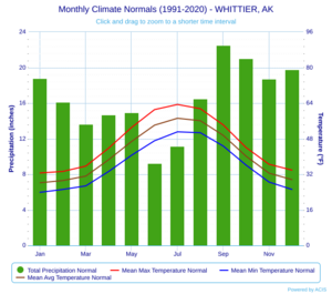
Whittier has a very wet and cool climate. It gets a lot of rain and snow, averaging over 197 inches (500 cm) of precipitation each year. This makes it one of the wettest places in Alaska. Whittier is at the northern edge of the world's northernmost temperate rainforest, the Tongass.
The average temperature in Whittier is about 41.1°F (5.1°C). July is usually the warmest month, with an average of 57.2°F (14.0°C). January is the coldest, averaging 28.2°F (-2.1°C). The temperature can get very cold in winter, sometimes dropping below 0°F (-18°C). The hottest temperature ever recorded was 88°F (31°C) in July 1966. The coldest was -29°F (-34°C) in December 1942.
| Climate data for Whittier, Alaska, 1991–2020 normals, extremes 1942–2011 | |||||||||||||
|---|---|---|---|---|---|---|---|---|---|---|---|---|---|
| Month | Jan | Feb | Mar | Apr | May | Jun | Jul | Aug | Sep | Oct | Nov | Dec | Year |
| Record high °F (°C) | 54 (12) |
53 (12) |
54 (12) |
66 (19) |
76 (24) |
82 (28) |
88 (31) |
87 (31) |
73 (23) |
71 (22) |
56 (13) |
48 (9) |
88 (31) |
| Mean maximum °F (°C) | 42.4 (5.8) |
42.1 (5.6) |
44.7 (7.1) |
53.5 (11.9) |
63.6 (17.6) |
71.8 (22.1) |
73.4 (23.0) |
71.0 (21.7) |
61.8 (16.6) |
51.5 (10.8) |
45.1 (7.3) |
42.1 (5.6) |
75.2 (24.0) |
| Mean daily maximum °F (°C) | 32.6 (0.3) |
33.3 (0.7) |
35.7 (2.1) |
43.8 (6.6) |
53.1 (11.7) |
61.1 (16.2) |
63.4 (17.4) |
61.5 (16.4) |
54.2 (12.3) |
44.0 (6.7) |
36.5 (2.5) |
33.9 (1.1) |
46.1 (7.8) |
| Daily mean °F (°C) | 28.2 (−2.1) |
29.2 (−1.6) |
31.2 (−0.4) |
38.6 (3.7) |
46.8 (8.2) |
54.1 (12.3) |
57.2 (14.0) |
56.1 (13.4) |
49.5 (9.7) |
40.1 (4.5) |
32.5 (0.3) |
29.6 (−1.3) |
41.1 (5.1) |
| Mean daily minimum °F (°C) | 23.9 (−4.5) |
25.2 (−3.8) |
26.8 (−2.9) |
33.3 (0.7) |
40.6 (4.8) |
47.1 (8.4) |
51.1 (10.6) |
50.7 (10.4) |
44.7 (7.1) |
36.1 (2.3) |
28.5 (−1.9) |
25.2 (−3.8) |
36.1 (2.3) |
| Mean minimum °F (°C) | 7.5 (−13.6) |
11.1 (−11.6) |
15.1 (−9.4) |
24.6 (−4.1) |
34.7 (1.5) |
41.2 (5.1) |
46.8 (8.2) |
45.0 (7.2) |
37.0 (2.8) |
25.6 (−3.6) |
15.5 (−9.2) |
12.3 (−10.9) |
3.0 (−16.1) |
| Record low °F (°C) | −18 (−28) |
−15 (−26) |
−5 (−21) |
5 (−15) |
15 (−9) |
25 (−4) |
35 (2) |
34 (1) |
23 (−5) |
14 (−10) |
−10 (−23) |
−29 (−34) |
−29 (−34) |
| Average precipitation inches (mm) | 18.82 (478) |
16.15 (410) |
13.65 (347) |
14.71 (374) |
14.93 (379) |
9.21 (234) |
11.19 (284) |
16.52 (420) |
22.52 (572) |
21.05 (535) |
18.75 (476) |
19.81 (503) |
197.31 (5,012) |
| Average snowfall inches (cm) | 50.0 (127) |
44.8 (114) |
55.1 (140) |
15.9 (40) |
1.8 (4.6) |
0.0 (0.0) |
0.0 (0.0) |
0.0 (0.0) |
0.0 (0.0) |
5.9 (15) |
33.3 (85) |
61.4 (156) |
268.2 (681.6) |
| Average precipitation days (≥ 0.01 in) | 17.6 | 16.7 | 16.3 | 16.4 | 14.7 | 14.5 | 17.9 | 17.2 | 18.4 | 19.5 | 18.3 | 20.2 | 207.7 |
| Average snowy days (≥ 0.1 in) | 11.0 | 10.0 | 10.2 | 4.1 | 0.5 | 0.0 | 0.0 | 0.0 | 0.0 | 2.0 | 8.5 | 12.2 | 58.5 |
| Source 1: NOAA | |||||||||||||
| Source 2: XMACIS2 (mean maxima/minima 1981–2010) | |||||||||||||
People of Whittier
| Historical population | |||
|---|---|---|---|
| Census | Pop. | %± | |
| 1950 | 627 | — | |
| 1960 | 809 | 29.0% | |
| 1970 | 130 | −83.9% | |
| 1980 | 198 | 52.3% | |
| 1990 | 243 | 22.7% | |
| 2000 | 182 | −25.1% | |
| 2010 | 220 | 20.9% | |
| 2020 | 272 | 23.6% | |
| 2022 (est.) | 265 | 20.5% | |
| U.S. Decennial Census | |||
Whittier first appeared on the U.S. census in 1950. It officially became a city in 1969.
In 2018, about 205 people lived in Whittier. Most of them live in the 14-story Begich Towers. The population is made up of different groups. About 68.3% are White, 10.6% are Asian, 6.9% are Hispanic, and 5.7% are Native American.
There are 124 households in the town. The average household has about 1.79 people. Many people in Whittier are married or have children. The median income for a household in 2019 was $45,000.
Getting Around Whittier
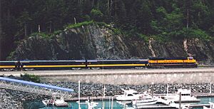
Whittier Harbor
Whittier has a harbor and a deep-water port. This port is used by large cruise ships and the Alaska Marine Highway ferries.
Airfield and Seaplane Dock
Whittier Airport (ICAO: PAWR) has one gravel runway. It is 1,480 feet (451 meters) long. The airport is not kept clear in winter. In 2005, there were about 700 flights a year. Most were small private planes. The runway used to be longer, but it was damaged by the 1964 earthquake.
The city also has a dock for seaplanes.
The Whittier Tunnel
The Anton Anderson Memorial Tunnel is often called the Whittier tunnel or Portage tunnel by locals. It goes through Maynard Mountain. This tunnel connects Whittier to the Seward Highway and the rest of Alaska. It is the only land route into the town. At 13,300 feet (4,054 meters), it is the second-longest highway tunnel in North America. It is also the longest tunnel used by both cars and trains.
Alaska Rail Connection
Whittier is an important connection point for the Alaska Railroad. It links Alaska's rail system to Canada and the rest of the U.S. This connection happens through special rail barges that carry train cars.
See also
 In Spanish: Whittier (Alaska) para niños
 | Victor J. Glover |
 | Yvonne Cagle |
 | Jeanette Epps |
 | Bernard A. Harris Jr. |


