Wildwood, Missouri facts for kids
Quick facts for kids
Wildwood, Missouri
|
||
|---|---|---|

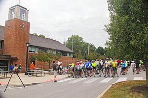
Bicycle event at Wildwood Municipal Building, October 2016
|
||
|
|
||
| Motto(s):
“Planning Tomorrow Today”
|
||

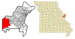
Location of Wildwood, Missouri
|
||
| Country | United States | |
| State | Missouri | |
| County | St. Louis | |
| Area | ||
| • Total | 66.89 sq mi (173.25 km2) | |
| • Land | 66.68 sq mi (172.70 km2) | |
| • Water | 0.21 sq mi (0.55 km2) | |
| Elevation | 764 ft (233 m) | |
| Population
(2020)
|
||
| • Total | 35,417 | |
| • Density | 531.14/sq mi (205.07/km2) | |
| Time zone | UTC−6 (Central (CST)) | |
| • Summer (DST) | UTC−5 (CDT) | |
| FIPS code | 29-79820 | |
| GNIS feature ID | 2397311 | |
| Website | www.cityofwildwood.com | |
Wildwood is a city located in St. Louis County, Missouri, in the United States. It is in the far western part of the county. In 2020, about 35,417 people lived there. Wildwood is known for its many outdoor spaces. These include the Al Foster Trail and other trails, parks, and nature reserves like Rockwoods Reservation and Babler State Park.
Contents
Exploring Wildwood's Location
Wildwood covers a total area of about 67 square miles (173 square kilometers). Most of this area is land, with a small part being water.
The city has several neighbors. To the north, you'll find Chesterfield. To the east are Clarkson Valley and Ellisville. South of Wildwood are Eureka and Pacific. Finally, to the west, it borders Franklin County.
Wildwood's Population
| Historical population | |||
|---|---|---|---|
| Census | Pop. | %± | |
| 2000 | 32,884 | — | |
| 2010 | 35,517 | 8.0% | |
| 2020 | 35,417 | −0.3% | |
| U.S. Decennial Census | |||
Population in 2020
The 2020 United States census counted 35,417 people living in Wildwood. There were 12,655 households and 10,730 families. The population density was about 531 people per square mile (205 people per square kilometer).
Most of the people in Wildwood, about 85.6%, were white. About 6% were Asian, and 1.6% were black or African-American. Other groups made up smaller parts of the population. About 2.7% of the people were of Hispanic or Latino background.
Many households, about 35.9%, had children under 18 living with them. Most households, 75.3%, were married couples. The average household had 2.8 people, and the average family had 3.1 people.
Population in 2010
In the 2010 census, Wildwood had 35,517 people. There were 12,112 households and 10,153 families. The population density was about 535 people per square mile (207 people per square kilometer).
The racial makeup of the city was mostly white (87.2%). Other groups included African American (6.7%), Asian (4.0%), and Native American (0.2%). About 2.3% of the population was Hispanic or Latino.
About 45.4% of households had children under 18. Most households (75.2%) were married couples living together. The average household size was 2.93 people, and the average family size was 3.24 people.
Education in Wildwood
Students in Wildwood attend schools in the Rockwood School District. One high school, Lafayette High School, is located right in the city.
For students looking for higher education, St. Louis Community College–Wildwood is a two-year public college. It is located near Route 100 and Route 109.
Police Services
The City of Wildwood gets its police services from the St. Louis County Police Department. This means the county police help keep Wildwood safe.
Local Culture and History
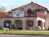
The Big Chief Restaurant is a special place in Wildwood. It is the only part left of a larger tourist area that opened in 1928 along U.S. Route 66. Because of its history, it was added to the National Register of Historic Places in 2003.
Famous People from Wildwood
Many notable people have connections to Wildwood:
- David Freese, a former baseball player for the St. Louis Cardinals, grew up here.
- Ryan Howard, a former baseball player for the Philadelphia Phillies, also grew up in Wildwood.
- Albert Pujols, another baseball star for the St. Louis Cardinals, lived in Wildwood for a short time.
- Jesse Smith, a racing driver, was born in Wildwood.
- Kelly Stables, an actress, grew up in the city.
- Luke Voit, a Major League Baseball player, also grew up in Wildwood.
See also
In Spanish: Wildwood (Misuri) para niños
 | Precious Adams |
 | Lauren Anderson |
 | Janet Collins |


