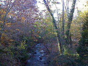
Willeo Creek facts for kids
Willeo Creek is a stream about 6.7 miles (10.8 km) long in the U.S. state of Georgia. It is located in the northern part of metro Atlanta. Willeo Creek is an important stream that flows into the Chattahoochee River. It joins the Chattahoochee River at Bull Sluice Lake, which is just before Morgan Falls Dam and after the Chattahoochee Nature Center.
These two streams, Willeo Creek and the Chattahoochee River, form almost all of the border between Fulton County to the east and Cobb County to the west.
Creek's Name
Willeo Creek was named after Captain Willeyoe. He was a leader of the Cherokee people.
Location and History
Until early 1932, Willeo Creek was entirely within Cobb County. However, Cobb County then gave the town of Roswell to Fulton County on May 9, 1932. Before that year, Roswell's neighbors were in what used to be Milton County. Giving everything east of the creek to Fulton County helped the new section, now called north Fulton, connect better.
Only a small part near the creek's beginning is still completely in Cobb County. At this point, the county line goes straight north to become the border between Cherokee County and Fulton County. This border continues until it meets the Little River. From this spot, just south of a hill near Sweat Mountain, the creek flows south-southeast. Because of new town borders, Willeo Creek now also forms most of the western edge of the city of Roswell.
Monitoring the Water
There is a special device called a stream gauge on Willeo Creek. It is run by the USGS (United States Geological Survey). This gauge, named WLOG1, is located on the Georgia 120 bridge. You can find it at 34°00′10″N 84°23′40″W / 34.00278°N 84.39444°W.
This location is often called "near Roswell" or "2SW Roswell," because it's about 2 miles (3.2 km) southwest of the center of Roswell. At this point, the creek has a drainage basin of 16.1 square miles (41.7 km2). This means that all the rain and water from this area flows into Willeo Creek.
Unlike some other creeks like Big Creek or Sope Creek, the National Weather Service usually does not issue flood warnings specifically for Willeo Creek. The worst known flooding happened in September 2009, during a very heavy rainfall event.
Lakes and Smaller Streams
Gilhams Lake is a long, narrow lake located on the upper part of Willeo Creek. Many smaller, unnamed streams flow into Willeo Creek. However, several lakes on these smaller streams do have names.
Here are some of the lakes that connect to Willeo Creek, listed from north to south based on where their water joins the main creek:
- Grande Loch
- Cochrans Lake
- Highland Lake
- Mitchell Lake
- Lake Charles
- Maddox Lake
- Clary Lakes
- Spring Lake
- Bishop Lake
- Princeton Lakes
- Willow Point Lake
- Lake Jackson
Most of these lakes are on the west side of Willeo Creek, in the far eastern part of Cobb County.
 | George Robert Carruthers |
 | Patricia Bath |
 | Jan Ernst Matzeliger |
 | Alexander Miles |


