Sweat Mountain facts for kids
Quick facts for kids Sweat Mountain |
|
|---|---|

Sweat Mountain
|
|
| Highest point | |
| Elevation | 1,688 ft (515 m) |
| Geography | |
| Parent range | Appalachian Mountains |
| Topo map | USGS Mountain Park |
| Climbing | |
| Easiest route | residential streets |
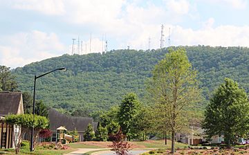
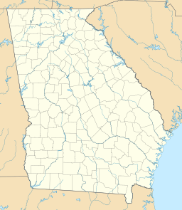
Sweat Mountain is a small mountain located in Cobb County, Georgia, near the city of Atlanta. It stands about 1,688 feet (514.5 meters) tall. This makes it the second-highest point in Cobb County, right after Kennesaw Mountain.
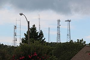
Because it's tall, Sweat Mountain is a great spot for radio and television towers. You'll see many antennas here for cellphones, broadcasting, and even amateur radio (also known as ham radio). Other nearby mountains, like Stone Mountain and Kennesaw Mountain, are protected as parks. This means they can't have many towers, so Sweat Mountain has become a busy place for technology. However, all these towers and houses make it harder to see the mountain clearly from some areas.
Sweat Mountain is also part of a ridge that separates two important river areas. To the south, water flows into the Chattahoochee River. To the north, water flows into Lake Allatoona, which is fed by the Etowah River.
Contents
History of Sweat Mountain
For a long time, the Wigley family owned all of Sweat Mountain. Henry Clay Wigley lived at the bottom of the mountain for many years. A gravel road near his house led straight to the top.
Years ago, before satellites were common, a U.S. Forest Service ranger would climb a tall fire tower on the mountain. From there, they would help locate wildfires. This tower is no longer there, but you can still find a special marker in the concrete where one of its legs once stood. On the north side of the mountain's top, there are natural rock formations. These include a rock shelter where one or two campers could stay.
Wigley Road used to go all the way from Sandy Plains Road to Georgia 92. But it was closed in the 1970s because it was not kept up well. Now, the main part of Wigley Road turns into Jamerson Road. If you follow the old Wigley Road to its end, you'll find a place where natural springs created a big muddy area. This mud was a big reason why the road was closed.
In the early 1970s, a lake at the base of the mountain, off Mountain Road, was the site of a large music festival.
In April 2006, a small tornado (an F1 on the Fujita scale) touched the south side of the mountain. It caused only minor damage to some homes. The thunderstorm then moved east, causing much more serious damage in other places.
Mountain View Area
The Mountain View area gets its name from the clear view it offers of Sweat Mountain. This area has several places named "Mountain View," like the Cobb County Public Library, a Chattahoochee Tech campus, and the Mountain View Aquatics Center. There's also the Mountain View Elementary School and fire stations nearby.
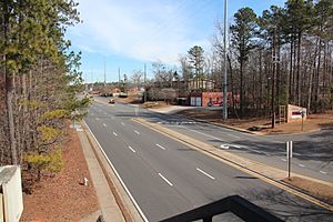
This community is mostly found around the busy intersection of Sandy Plains Road and Shallowford Road. In the 1990s, this area quickly changed from forest to many parking lots and strip malls. Both roads, which used to be small two-lane roads with a four-way stop, are now wide, multi-lane roads at the intersection.
Gordy Parkway was built to connect hundreds of new homes west of Sandy Plains Road. Most of the existing forest was clear-cut to make room for these houses. The family of Frank Gordy, who owned the famous restaurant The Varsity, owned much of this land. They donated some land for the Chattahoochee Tech campus, which was then given to the state technical college.
Even though they were fairly new, three of the five main stores in the area changed hands. For example, Kmart became Home Depot, and Harris Teeter was sold to Kroger. There is also a movie theater with many screens. A similar fast growth in building has happened in Hickory Flat in the 2000s.
Broadcasters on Sweat Mountain
Many broadcast stations have their transmitters and antennas very close to the top of Sweat Mountain. Here are some of them:
Radio Stations
- WBZY FM 105.7 in Canton, owned by Clear Channel Communications.
- W265AV FM 100.9 in Woodstock, owned by Immanuel Broadcasting Network.
- W201DM FM 88.1, a newer station that relays KAWZ from Idaho.
There have also been plans for other small radio stations (called broadcast translators) to serve Woodstock and the Sweat Mountain area.
Television Stations
- WATC-DT 41 (digital channel 57.1) in Atlanta, owned by Community Television, Inc.
In the past, there were also transmitters for mobile TV services on the mountain. These services allowed people to watch TV on their phones or other mobile devices. One service was called MediaFLO, and another was from Manifest Wireless, a company related to Dish Network. These signals were strong, but the services were never fully launched to the public.
Amateur Radio Repeaters
Amateur radio, or "ham radio," uses repeaters to help radio signals travel further. Sweat Mountain is home to several of these repeaters.
Radio Repeaters
- W4PME 145.410 (North Fulton Amateur Radio League)
- N4NQV 147.345 (Big Shanty Repeater Group)
- W4PME 224.620 (North Fulton Amateur Radio League)
- NF4GA 444.475 (North Fulton Amateur Radio League)
- W5JR 927.0125 (North Fulton Amateur Radio League)
- N4YCI 927.5750
Television Repeaters
- N4NEQ 427.2500 MHz AM TV (Atlanta ATV)
Digital Packet Radio
- N4NEQ 144.390 (N4NEQ-2 APRS digipeater) (Big Shanty Repeater Group)
- KD4NC/R 146.73 (AX.25 repeater)
 | Stephanie Wilson |
 | Charles Bolden |
 | Ronald McNair |
 | Frederick D. Gregory |


