
Wolf Run (Muncy Creek tributary) facts for kids
Quick facts for kids Wolf Run |
|
|---|---|
 |
|
| Physical characteristics | |
| Main source | western Wolf Township, Lycoming County, Pennsylvania |
| River mouth | Muncy Creek in Muncy Creek Township, Lycoming County, Pennsylvania 41°12′40″N 76°48′08″W / 41.2111°N 76.8023°W |
| Length | 7.6 mi (12.2 km) |
| Basin features | |
| Progression | Muncy Creek → West Branch Susquehanna River → Susquehanna River → Chesapeake Bay |
| Basin size | 11.1 sq mi (29 km2) |
| Tributaries |
|
Wolf Run is a stream in Lycoming County, Pennsylvania, in the United States. It flows into Muncy Creek, which then joins the West Branch Susquehanna River. The stream is about 7.6 miles (12.2 km) long.
Wolf Run flows through three different areas: Wolf Township, Muncy Township, and Muncy Creek Township. The land area that drains into Wolf Run, called its watershed, is about 11.1 square miles (29 km2). Many years ago, a fort stood near Wolf Run for a long time. Today, at least three bridges cross over the stream.
Contents
Where Does Wolf Run Flow?

Wolf Run starts in the western part of Wolf Township. It begins between two hills called Roundtop and Long Hill.
The stream first flows south through a valley. Then, it turns southeast and later south again. As it leaves the valley in southern Wolf Township, it goes under U.S. Route 220. It then turns southwest and enters Muncy Township.
In Muncy Township, Wolf Run slowly turns west. It flows past the town of Pennsdale before turning south. Near the edge of the township, it goes under Interstate 180. After this, it enters Muncy Creek Township.
The stream turns west and then south again, running next to the West Branch Susquehanna River. Finally, near the town of Muncy, Wolf Run meets Muncy Creek. This meeting point is very close to where Muncy Creek itself joins the West Branch Susquehanna River. Wolf Run joins Muncy Creek only about 0.06 miles (0.097 km) before Muncy Creek reaches the larger river.
What's in the Water?
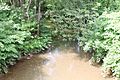
Wolf Run sometimes has problems with siltation, which means too much mud and dirt builds up in the stream. Its banks also wear away, which is called stream bank erosion.
Every year, about 2,166,200 pounds (982,600 kg) of sediment (like dirt and small rocks) flows through Wolf Run. A large part of this sediment, about 1,362,400 pounds (618,000 kg) per year, comes from farmlands. Stream banks add about 503,000 pounds (228,000 kg) of sediment each year. Forests contribute about 116,800 pounds (53,000 kg), and hay fields or pastures add about 115,400 pounds (52,300 kg).
Smaller amounts come from developed areas (49,000 pounds (22,000 kg)) and areas where land is changing (16,800 pounds (7,600 kg)). Coal mines in the watershed add about 2,800 pounds (1,300 kg) of sediment yearly. Wetlands in the area do not add any sediment to the stream.
Land Around Wolf Run
The lowest parts of the Wolf Run watershed are about 500 feet (150 m) above sea level. The highest parts are much higher, around 1,400 feet (430 m) above sea level.
The entire area around Wolf Run is part of the Ridge-and-Valley Appalachians region. This means the landscape has many long, parallel ridges and valleys.
The rocks in the Wolf Run watershed are mostly sedimentary. About 50 percent are interbedded sedimentary rocks (layers of different rock types). About 30 percent is sandstone, 15 percent is shale, and 5 percent are carbonate rocks.
The Wolf Run watershed covers about 11.1 square miles (29 km2) and has a total of 20.7 miles (33.3 km) of streams. Most of the land, about 63.1 percent, is covered by forests. Another 27.7 percent is used for farming. About 8.5 percent of the land is developed with low-intensity buildings. A small part, 0.5 percent, has coal mines, and 0.1 percent is covered by wetlands.
History of Wolf Run
The Ancient Fortification
A very old earth structure, called the "Ancient Fortification," was built near Wolf Run many hundreds of years ago. It was less than 0.2 miles (0.32 km) north of Muncy Creek. In the late 1800s, a historian named John Franklin Meginness thought it was between 300 and 500 years old.
This fort was square-shaped and covered about one acre of land. It was a topic of much discussion in the early 1900s. When explorer Conrad Weiser visited the area in 1737, the fort was already very old and falling apart. It's possible that a French explorer named Étienne Brûlé visited the area near Wolf Run as early as 1615, but this is not certain.
Roads, Mills, and Railroads
The Genesee Road, which opened in the early 1800s, passed by Wolf Run. This road connected Muncy to the Genesee River. A stone gristmill, used for grinding grain, was built on the stream by William Ellis.
Later, in the 1800s or early 1900s, a railroad was built near Wolf Run. It even passed over the old Ancient Fortification. When the railroad was being built, workers found several old items, including a piece of Indian pottery. They also found charcoal and other signs of ancient fires near the stream. In the late 1800s, the Cogan House school was located on Wolf Run.
Wolf Run got its name because many wolves used to live near the stream a long time ago.
Modern Bridges
In 2013, Lycoming County worked on improving the bridge for U.S. Route 220 over Wolf Run. This project cost $770,000. Two other bridges over the stream were also repaired in the same year, each costing a little over $1 million.
Animals and Plants
Wolf Run is known as a High-Quality Coldwater Fishery. This means its cold water is good for fish. It's also a Migratory Fishery, which means fish that travel long distances use it. Some parts of the stream do not have a riparian buffer, which is a strip of plants along the banks that helps protect the water.
In a book from 1909, Edward A. Straub wrote that large catfish and eels lived in Wolf Run.
A very large white oak tree used to grow near Wolf Run on the Adlum Farm. Its trunk was over 26 feet (7.9 m) around! Sadly, it was cut down in 1852.
Images for kids
-
Wolf Run
