Woodland Park, New Jersey facts for kids
Quick facts for kids
Woodland Park, New Jersey
|
||
|---|---|---|
|
Borough
|
||
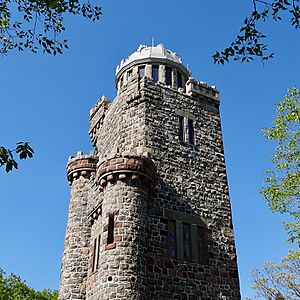
Lambert Tower in Garret Mountain Reservation
|
||
|
||
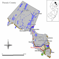
Map of Woodland Park in Passaic County (shown under its former name West Paterson). Inset: Location of Passaic County highlighted in the State of New Jersey.
|
||
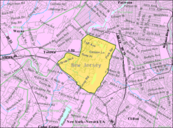
Detailed Census Bureau map of West Paterson in 2000
|
||
| Country | ||
| State | ||
| County | ||
| Incorporated | May 1, 1914 (as West Paterson) | |
| Renamed | January 1, 2009 (to Woodland Park) | |
| Government | ||
| • Type | Faulkner Act (small municipality) | |
| • Body | Borough Council | |
| Area | ||
| • Total | 3.08 sq mi (7.97 km2) | |
| • Land | 2.94 sq mi (7.61 km2) | |
| • Water | 0.14 sq mi (0.36 km2) 4.51% | |
| Area rank | 330th of 565 in state 13th of 16 in county |
|
| Elevation | 348 ft (106 m) | |
| Population
(2020)
|
||
| • Total | 13,484 | |
| • Estimate
(2023)
|
13,138 | |
| • Rank | 192nd of 565 in state 7th of 16 in county |
|
| • Density | 4,588.0/sq mi (1,771.4/km2) | |
| • Density rank | 127th of 565 in state 8th of 16 in county |
|
| Time zone | UTC−05:00 (Eastern (EST)) | |
| • Summer (DST) | UTC−04:00 (Eastern (EDT)) | |
| ZIP Code |
07424
|
|
| Area code(s) | 973 | |
| FIPS code | 3403182423 | |
| GNIS feature ID | 0885439 | |
Woodland Park (which used to be called West Paterson) is a small town, known as a borough, in Passaic County, New Jersey. In 2020, about 13,484 people lived there.
The area that is now Woodland Park became a borough in 1914. It was first named West Paterson. This happened when the New Jersey Legislature passed a law, taking parts of Little Falls Township to create the new borough.
Later, in 2008, the people living in West Paterson voted to change the town's name to Woodland Park. This new name became official on January 1, 2009.
Contents
Geography of Woodland Park
Woodland Park covers about 3.08 square miles (7.97 square kilometers). Most of this area is land, about 2.94 square miles (7.61 square kilometers). The rest is water, which is about 0.14 square miles (0.36 square kilometers).
A stream called Slippery Rock Brook flows through Woodland Park. It is a small river that feeds into the Passaic River. This brook flows north and helps drain water from the western side of First Watchung Mountain. It passes through the city of Paterson and then Woodland Park.
Woodland Park shares its borders with several other towns in Passaic County. These include Clifton, Little Falls, Paterson, and Totowa.
Why Woodland Park Changed Its Name
In November 2008, residents of West Paterson voted to change the town's name to Woodland Park. This was a very close vote, with only 33 votes making the difference. It was the fourth time people tried to change the name of West Paterson. Previous suggested names like "Whispering Pines," "West Park," and "Garret Mountain" were rejected in earlier votes.
Changing a town's name is not new in New Jersey. For example, Dover Township became Toms River Township in 2006. Also, Washington Township became Robbinsville Township in 2007. Another nearby town, East Paterson, changed its name to Elmwood Park in 1972.
Both East and West Paterson changed their names to avoid being confused with the larger city of Paterson. Paterson is a much bigger city that faces more challenges. People who wanted the name change in West Paterson believed it would improve the town's image. They thought it would also help property values.
However, some people did not want the name change. Businesses and the fire department worried about the costs of updating everything with the new name. They also felt it would make people forget the town's history as West Paterson.
After the name change, some residents tried to change it back to West Paterson. Another vote was held on November 3, 2009. This proposal was also defeated, meaning the name Woodland Park stayed.
There is another area called Woodland Park in Summit, Union County. This area is not an official town, but it shares the same name.
Economy and Businesses
Several important companies have a presence in Woodland Park.
Cytec Industries is a company that makes special chemicals and materials. It was formed in 1993 from parts of another company called American Cyanamid. In 2015, a company named Solvay S.A. bought Cytec.
North Jersey Media Group is a large media company owned by Gannett. This group publishes newspapers like The Record and Herald News. The Herald News moved its operations to Woodland Park in 1999. Later, The Record also moved its staff from Hackensack to Woodland Park between 2008 and 2010.
Parks and Recreation
Woodland Park has some great places for outdoor activities.
Garret Mountain Reservation is a large county park that covers 568 acres (2.3 square kilometers). It is home to Lambert Castle and offers amazing views of the New York City skyline. The park is about 500 feet (152 meters) above sea level. Most of this park is in Woodland Park, but parts of it also reach into Paterson and Clifton.
Rifle Camp Park is another county park, covering 225 acres (0.9 square kilometers). It is mostly in Woodland Park, but a small part extends into Clifton. This park has many things to do, including hiking trails, an observatory for looking at stars, and a nature center. There is also a fitness trail, an amphitheater, and a special spot for bird watching. Scout groups can even use an overnight camping area.
Population and People
| Historical population | |||
|---|---|---|---|
| Census | Pop. | %± | |
| 1920 | 1,858 | — | |
| 1930 | 3,101 | 66.9% | |
| 1940 | 3,306 | 6.6% | |
| 1950 | 3,931 | 18.9% | |
| 1960 | 7,602 | 93.4% | |
| 1970 | 11,692 | 53.8% | |
| 1980 | 11,293 | −3.4% | |
| 1990 | 10,982 | −2.8% | |
| 2000 | 10,987 | 0.0% | |
| 2010 | 11,819 | 7.6% | |
| 2020 | 13,484 | 14.1% | |
| 2023 (est.) | 13,138 | 11.2% | |
| Population sources: 1920 1920–1930 1940–2000 2000 2010 2020 |
|||
Population in 2010
The 2010 United States census showed that 11,819 people lived in Woodland Park. There were 4,632 households, which are groups of people living together. About 3,215 of these were families.
The population density was about 3,988 people per square mile (1,540 per square kilometer). Most residents were White (82.33%). Other groups included Black or African American (4.23%), Asian (4.20%), and Native American (0.16%). About 20.66% of the population identified as Hispanic or Latino.
About 19.7% of the people were under 18 years old. The average age in Woodland Park was 41.9 years.
Education in Woodland Park
Students in Woodland Park attend public schools from kindergarten through eighth grade within the Woodland Park School District. This district has three schools. In the 2018–19 school year, about 1,080 students were enrolled.
The schools in the district are:
- Charles Olbon School: For students in grades K–2.
- Beatrice Gilmore School: For students in grades 3–4.
- Memorial Middle School: For students in grades 5–8.
For high school, students from Woodland Park go to Passaic Valley Regional High School. This school also serves students from Little Falls and Totowa. The high school building is located in Little Falls. In the 2018–19 school year, the high school had about 1,186 students.
Berkeley College also has a campus in Woodland Park, located at Garret Mountain.
Transportation and Roads
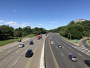
As of 2010, Woodland Park had about 33.47 miles (53.87 kilometers) of roads. The town itself maintains most of these roads.
Interstate 80 runs along the northwest edge of Woodland Park for about 1.0 mile (1.6 kilometers). It connects Woodland Park to Totowa in the west and Paterson in the east. Exit 56 on Interstate 80 leads to County Route 636 (Squirrelwood Road).
U.S. Route 46 also passes near Woodland Park. It enters from Little Falls and follows the southern border of the borough for about 0.7 miles (1.1 kilometers) before continuing into Clifton.
Public Transportation Options
NJ Transit provides bus services for residents. Buses on the 191 and 194 routes travel to the Port Authority Bus Terminal in Midtown Manhattan. Local bus service is available on the 704 route.
Notable People from Woodland Park
Many interesting people have lived in or are connected to Woodland Park:
- Rick Cerone (born 1954): A former professional baseball catcher who played for the New York Yankees.
- Jeff Chase (born 1968): An actor in movies and TV shows. He also played football in the Arena Football League.
- Darius Hamilton (born 1993): A football player who played defensive end for the Rutgers Scarlet Knights football team.
- Keith Hamilton (born 1971): A defensive tackle who played his entire 12-year career with the New York Giants football team.
- Kendall Holt (born 1981): A former professional boxer who held a world title in the junior welterweight division.
- Víctor Santos (born 1976): A professional baseball pitcher who played for several MLB teams.
- Natalia Shaposhnikova (born 1961): A former Soviet gymnast and two-time Olympic champion. She now lives and coaches gymnastics in Woodland Park.
- Omar Sheika (born 1977): A former professional boxer who challenged for world titles multiple times.
- Frank Tripucka (1927–2013): A former professional football quarterback.
See also
 In Spanish: Woodland Park (Nueva Jersey) para niños


