Woorabinda, Queensland facts for kids
Quick facts for kids WoorabindaQueensland |
|||||||||||||||
|---|---|---|---|---|---|---|---|---|---|---|---|---|---|---|---|
 |
|||||||||||||||
| Population | 1,019 (2021 census) | ||||||||||||||
| • Density | 4.630/km2 (11.99/sq mi) | ||||||||||||||
| Established | 1927 | ||||||||||||||
| Postcode(s) | 4713 | ||||||||||||||
| Area | 220.1 km2 (85.0 sq mi) | ||||||||||||||
| Time zone | AEST (UTC+10:00) | ||||||||||||||
| Location |
|
||||||||||||||
| LGA(s) | Aboriginal Shire of Woorabinda | ||||||||||||||
| Region | Central Queensland | ||||||||||||||
| State electorate(s) | Gregory | ||||||||||||||
| Federal Division(s) | Flynn | ||||||||||||||
|
|||||||||||||||
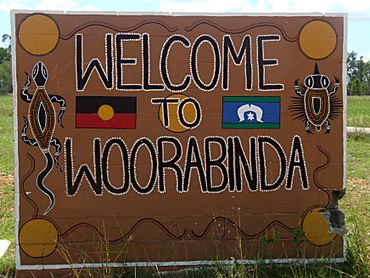
Woorabinda is a town and area in the Aboriginal Shire of Woorabinda, Queensland, Australia. It is a special community for Aboriginal people. In 2021, Woorabinda had a population of 1,019 people. Most residents, about 91.6%, identify as Aboriginal or Torres Strait Islander.
Contents
Where is Woorabinda?
Woorabinda is located in Central Queensland. It is about a two-hour drive west of the city of Rockhampton.
Local Water and Roads
The Mimosa Creek flows nearby and provides water for the town. During the rainy season, roads can flood. This means the town can sometimes be cut off from other places.
You can get to Woorabinda using the Fitzroy Developmental Road. This road is sealed (paved) to the north towards Duaringa. From there, it connects to the Capricorn Highway which goes to Rockhampton. To the south, the road is gravel. It leads to Bauhinia, where it meets the Dawson Highway for access to Gladstone.
To the east, the Baralaba-Woorabinda Road is sealed. However, it can also be cut off by floods during wet weather. West of Woorabinda, there are many cattle farms. These areas are reached by gravel roads.
Woorabinda Airstrip
There is also a sealed airstrip north of town. It is used for special flights, like those for medical emergencies. Regular passenger flights do not use this airstrip.
A Look at Woorabinda's Past
The Wadja Language
The Wadja language is an Aboriginal language from Central Queensland. It is also known by other names like Wadjigu. This language was spoken in areas including the Aboriginal Shire of Woorabinda. It also covered parts of the Central Highlands Region, the Blackdown Tablelands, and near towns like Woorabinda and Springsure.
How Woorabinda Got Its Name
The name Woorabinda was chosen in 1927. Herbert Cecil Colledge, who was in charge of the settlement, picked the name. It comes from Aboriginal words: woora means kangaroo and binda means camp. So, Woorabinda means "kangaroo camp."
The Move to Woorabinda
In 1926, the Queensland Government asked hundreds of Aboriginal families to move to Woorabinda. About 300 people from Taroom had to walk over 200 kilometers to get there. In 2014, the community remembered this long walk with a special event.
Woorabinda State School first opened in 1928. It closed for a time in 1970 but then reopened.
Special Land Ownership
Woorabinda is a "DOGIT" Aboriginal community. This means it has a special way of owning land. The land is held in trust by the local council. The council then manages it for the community. This system only applies to former Aboriginal reserves.
Relocation from Cape Bedford
A Wartime Move
In May 1942, during World War II, a Lutheran Aboriginal mission at Cape Bedford in North Queensland was closed. The government wanted to use the area as an army camp. They also worried about the loyalty of Aboriginal people to the German Lutheran pastor.
Because of this, 254 Aboriginal people from Cape Bedford were moved. They were first taken by road and boat to Townsville. Then, they traveled by train to Woorabinda. This journey was difficult. People did not have enough food or blankets during the cold winter trip.
Life in Woorabinda
There were some disagreements between the people from Cape Bedford and the Woorabinda residents. This was partly because the Cape Bedford people had strong Christian beliefs. However, the new arrivals also got to experience cultural events they hadn't seen before, like corroborees.
They continued to hold their own Lutheran church services. They sang hymns translated into their language, Guugu Yimithirr. This became a very important part of their church identity. They kept their own identity separate from the Woorabinda residents during the seven years they stayed there.
Challenges and Changes
Many people became sick and died because of poor living conditions. They were not used to the cold inland climate. The official number of deaths was 33, but it might have been as high as 48. There were also 13 babies born during this time. For the first time, the Cape Bedford people also had paid jobs and went to school.
Returning Home
After the war, in 1949, the survivors were allowed to go back to Cape Bedford. This place is now called Hopevale. Most of them returned north. However, a small group stayed in Woorabinda. This group still keeps a connection to their northern home today.
How People Live and Work
Jobs and Businesses
In 2013, about 70% of people in Woorabinda did not have jobs. This was much higher than in nearby towns. Most jobs in Woorabinda come from government services. There is also a local takeaway cafe. The Woorabinda Pastoral Company, owned by the council, runs cattle farms. One of these farms, Foleyvale Station, is also part of the Woorabinda lands.
Learning in Woorabinda
Woorabinda State School
Woorabinda State School is a primary school for students from Prep to Year 6. In 2017, it had 144 students. The school has a special education program. Its motto is 'Proud and Deadly'. The school also has a tuck shop where the community can buy meals. There is a Community Indigenous Knowledge Centre at the school. It is a library for everyone in the community.
Wadja Wadja High School
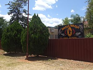
Wadja Wadja High School is a private high school for students from Year 7 to Year 12. In 2017, it had 77 students. In 2020, all 76 students attending the school were Indigenous.
High School Options
There is no government high school in Woorabinda. The closest government high school is Baralaba State School, which goes up to Year 10. A school bus service takes students there. For students who want to study up to Year 12, they can do distance education (learning from home) or go to a boarding school.
Community Places
Woorabinda has a Knowledge Centre, which is like a library. It is run by the Woorabinda Aboriginal Shire Council.
One Mob Fellowship is a church in Woorabinda. It is part of the Wesleyan Methodist Church.
Who Lives in Woorabinda?
The two main groups of people in Woorabinda are the Gangulu Nation and the Wadja Nation. Both groups have traditional claims to the land. The Wadja people's claim is mainly for the Woorabinda area. The Gangulu nation's claim covers a much larger area.
In 2008, Woorabinda had many more young people than other non-Indigenous communities. Half of the people living there were under 25 years old. This is much higher than the average for Australia.
In 2021, the population of Woorabinda was 1,019 people.
Music and Dance
Kulgoodah Dancers
In 2017, the Kulgoodah dancers from Woorabinda won the Dance Rites competition. This competition was started by Rhoda Roberts. She believes that dance and music have helped the young people in the community. It gives them a sense of purpose.
Miiesha
The singer-songwriter Miiesha came from this dance group. In 2020, she won the Best New Talent award at the National Indigenous Music Awards.
Famous People from Woorabinda
- Miiesha, a singer who has won an ARIA Music Award.
- Reggie Cressbrook, a player for the North Queensland Cowboys NRL team.
- Mick Gooda, an Aboriginal activist and former Social Justice Commissioner.
 | Isaac Myers |
 | D. Hamilton Jackson |
 | A. Philip Randolph |


