
Wortley, Leeds facts for kids
Quick facts for kids Wortley |
|
|---|---|
_-_geograph.org.uk_-_4940224.jpg) Wortley Recreation Ground |
|

Wortley
|
|
| OS grid reference | SE2632 |
| Metropolitan borough | |
| Metropolitan county | |
| Region | |
| Country | England |
| Sovereign state | United Kingdom |
| Post town | LEEDS |
| Postcode district | LS12 |
| Dialling code | 0113 |
| Police | West Yorkshire |
| Fire | West Yorkshire |
| Ambulance | Yorkshire |
| EU Parliament | Yorkshire and the Humber |
| UK Parliament |
|
Wortley (pronounced WURT-lee) is a part of Leeds, a large city in West Yorkshire, England. It's located about one mile west of the city centre. The local area of Leeds that includes Wortley is called Farnley and Wortley.
Long ago, around the 1700s, Wortley was known as Wirkelay. It started as a place where people wove cloth. Later, it became an industrial area with coal mines, brick factories, and railway yards. There was even a special round building called a roundhouse for steam trains. This old building is now used by a company that hires out large vehicles. In the 1880s, Wortley became part of the growing town of Leeds.
Wortley is split into three main parts: New Wortley, Upper Wortley, and Lower Wortley.
Contents
Exploring New Wortley
New Wortley is the part of Wortley closest to Leeds city centre and areas like Armley and Holbeck. It's also near HM Prison Leeds. This area mainly has tall apartment buildings and maisonettes built in the 1960s.
Discovering Upper Wortley
Upper Wortley is located between Armley and Lower Wortley. Its borders are Tong Road to the north and Oldfield Lane/Green Hill Lane to the south. Here, you'll find a mix of older Victorian houses, semi-detached homes from the 1950s, and newer, smaller apartment buildings and houses.
Visiting Lower Wortley
Lower Wortley is the furthest part of Wortley from the city centre. It's closer to places like Gildersome and Farnley, and it borders the Greenbelt area. This part of Wortley is between Oldfield Lane to the north and Gelderd Road to the south. Most of the houses in Lower Wortley are semi-detached homes from the 1950s, along with some newer apartments and houses.
.jpg)
Lower Wortley is home to large stores like Booker (which used to be Makro) and Matalan. You'll also find many car dealerships here. These businesses are popular because Lower Wortley is conveniently located near the Leeds Outer Ring Road and the M621 motorway, making it easy for people to get there.
.jpg)
Wortley's Past
Wortley grew a lot during the industrial revolution, just like other areas nearby. While Wortley had some smaller factories, its closeness to busy industrial places like Armley and Holbeck helped it grow steadily. At that time, Wortley was known for its many railway lines and two gasworks. One was smaller in Lower Wortley, and the largest one in Leeds was in New Wortley. This large gasworks used to have a huge spiral-shaped gas holder until early 2022.
After World War II, the look of Wortley changed a lot. The city of Leeds and private companies rebuilt many of the older, crowded areas. New Wortley saw a lot of new social housing, including tall apartment blocks and houses built quickly. Even though these houses were built near a gasworks, they had "all-electric" heating, which was common then. In 2009, these homes were connected to gas as part of a project to help with heating costs.
Lower Wortley and Upper Wortley changed less than New Wortley. Many of their larger Victorian terraced houses still stand. Most of the new building there was done by private companies, who built smaller, more traditional homes.
Between 1851 and 1852, the bones of the Armley Hippo were found in an old river channel. This type of hippopotamus is now extinct in the United Kingdom. The bones were found in an area that was once part of Wortley, where a large road junction called the Armley Gyratory is now.
Local Facilities and Parks
Wortley is mostly a place where people live, and it has a lot of residents. Even though it's close to Leeds City Centre and Armley Town Street, there are still many smaller local shops. There's also a big ASDA supermarket in Upper Wortley. You can find about 12 pubs, and while there are no sit-down restaurants, there are many take-away food places.
Wortley has three main parks for everyone to enjoy: Wortley Recreation Ground, Cliffe Park, and Western Flatts Park.
Wortley Recreation Ground is the park closest to the city centre. It offers great views of the surrounding areas, including the city centre itself. People sometimes call it New Wortley Recreation Ground. It has a playground for children, a skateboard park, three bowling greens, and pitches for football and rugby. The bowling greens and club building were used as a main filming location for a TV show called The Beiderbecke Connection in 1988.

Cliffe Park and Western Flatts Park are actually connected and form one large park. They used to be the gardens of two separate large houses, Cliffe House and Western Flatts House. Western Flatts House was taken down a long time ago. Cliffe House was given to the Leeds Education Committee in the 1930s and became a school for boys. However, it has been empty for many years now.

.jpg)
Lower Wortley Methodist Church on Branch Road was built in 1884. It now serves as a place where the Leeds North and West Foodbank gives out food to people who need it.
Schools in Wortley
Wortley has one high school called Dixons Unity Academy. It is located at the old West Leeds High School site. Nearby, in Old Farnley, is The Farnley Academy, and further west in Pudsey is Crawshaw Academy. The former Wortley High School building is waiting to be redeveloped. The old West Leeds Boys' High School building, which is a listed building, has been turned into apartments. There are also three primary schools in Wortley: Five Lanes, Lower Wortley, and Whingate primary schools.
Important Buildings
After the large gas holder in New Wortley was taken down, the most noticeable buildings in Wortley are the Clyde Grange and Clyde Court apartment blocks. These tall buildings are located off Tong Road and are the highest structures in the Wortley area.

Famous People from Wortley
Several well-known people have connections to Wortley:
- Brighton & Hove Albion footballer James Milner was born in Wortley.
- England and Manchester City footballer Kalvin Phillips was also born in Wortley.
- The area is linked to three soldiers who received the Victoria Cross during World War I. This is a very brave award. George Sanders was born in New Wortley in 1894. The graves of Arthur Poulter and Wilfred Edwards are in cemeteries in Wortley.
Images for kids
- Wortley, West Yorkshire
-
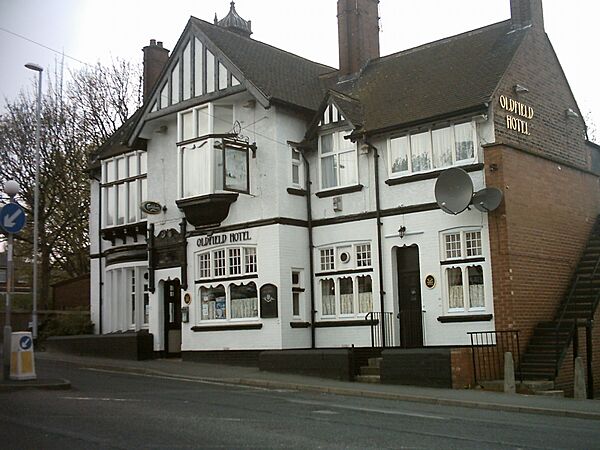
The Oldfield Hotel
-
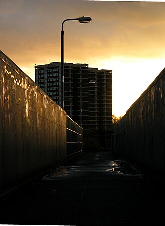
Clyde flats at sunset
-
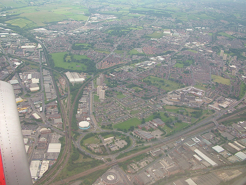
An aerial photograph of Wortley (and Armley to the right)
-

St Johns church, Lower Wortley


.jpg)
Location Map
 |
Armley | |
||
| Farnley | Holbeck | |||
| Beeston |
