Woudrichem facts for kids
Quick facts for kids
Woudrichem
|
|||
|---|---|---|---|
|
City and former municipality
|
|||

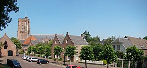
Martin Church and houses in 2015
|
|||
|
|||
| Country | Netherlands | ||
| Province | North Brabant | ||
| Municipality | Altena | ||
| Merged | 2019 | ||
| Area | |||
| • Total | 7.55 km2 (2.92 sq mi) | ||
| Elevation | 0 m (0 ft) | ||
| Population
(2021)
|
|||
| • Total | 4.680 | ||
| • Density | 292/km2 (760/sq mi) | ||
| Demonym(s) | Woudrichemmer | ||
| Time zone | UTC+1 (CET) | ||
| • Summer (DST) | UTC+2 (CEST) | ||
| Postcode |
4285
|
||
| Area code | 0183 | ||
Woudrichem (pronounced WOW-drik-hem) is a small city in the Netherlands. It used to be its own municipality (like a local government area). Today, it is part of the larger Altena municipality in the province of North Brabant.
Contents
Discovering Woudrichem's Past
Woudrichem started a very long time ago, in the 800s. It grew up around a marketplace on a riverbank. At first, the big Maas River didn't flow right past Woudrichem. Over time, the river's path changed, making Woudrichem an important spot.
Why Was Woudrichem Important?
Woudrichem was in a great location where the Maas and Waal rivers met. This made it a key place for trade and travel. It was also near the borders of three powerful areas: Duchy of Brabant, Gelre, and the County of Holland.
In 1322, the area around Woudrichem, called the Land of Altena, became part of County of Holland. Much later, in 1815, it joined the new province of North Brabant.
Becoming a City and Growing Strong
In the 1300s, Woudrichem became much bigger. In 1356, it was given "city rights" by Willem VII van Horne, the local lord. This meant it could govern itself more. The Count of Holland also moved a river toll (a fee for boats) to Woudrichem. This, along with special fishing rights, helped the town become very rich.
During this time, the Martin Church was built. In 1386, people started building a city wall to protect the town.
Challenges and Changes
After a while, Woudrichem's good times started to fade. In 1419, an important agreement called the Treaty of Woudrichem was signed. But then, the river toll moved to another city in 1420. A huge flood in 1421, called the Saint Elizabeth's flood, also caused a lot of damage.
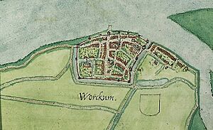
Because of its important location, Woudrichem was often attacked. It was besieged in 1405 and 1511. In 1572, Woudrichem supported William of Orange during a war. In 1573, soldiers called the Geuzen burned the city because they couldn't defend it.
Rebuilding and Fortifications
Between 1583 and 1588, a new set of strong defenses was built around Woudrichem. The city was rebuilt with help from nearby towns. Even so, it was still not very rich, and in 1700, it was given a tax break.
In 2006, Woudrichem celebrated 650 years since it got its city rights! People dressed in old costumes and acted out scenes from the past.
What's in a Name?
There are a few ideas about where the name Woudrichem came from. The most likely idea is that it means "wooded area" (from "wald" and "heim"). Another idea is that a lord named Waldrik built a house by the Waal River.
Over hundreds of years, the name Woudrichem has been spelled and said in many different ways. You can see some of these old names on a building in Woudrichem:
- ca. 866 UUalricheshem
- ca. 1000 Walderinghem
- 1178 Waldrichem
- 1230 Woudrichemerward
- 1241 Wodrinheim / Wodrincheym / Wodrinchem
- 1465 Woldrichem
- 1476 Woerchem
- 1500 Worrynckhem / Worrynhem
- 1536 Worcum / Worcom
- 1600 Worichem
- 1724 Wornichem
Today, people in the area often say Woerkum or Woerkem.
Where is Woudrichem?
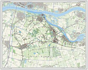
Woudrichem is located in the northern part of North Brabant, a province in the Netherlands. It sits right where the Waal and Afgedamde Maas rivers meet to form the Boven Merwede river.
The city of Woudrichem is the biggest town in its area. East of the city, across the river, you can find the famous Loevestein Castle in the province of Gelderland.
Notable People from Woudrichem
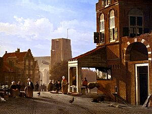
- Louwrens Hanedoes (1822–1905): A famous landscape painter who was born and died in Woudrichem. He started painting in a Romantic style and later moved to Realism.
Images for kids
See also
 In Spanish: Woudrichem para niños
 | Madam C. J. Walker |
 | Janet Emerson Bashen |
 | Annie Turnbo Malone |
 | Maggie L. Walker |


