Wurtland, Kentucky facts for kids
Quick facts for kids
Wurtland, Kentucky
|
|
|---|---|

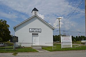
Wurtland Union Church
|
|

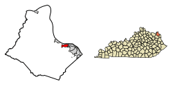
Location of Wurtland in Greenup County, Kentucky.
|
|
| Country | United States |
| State | Kentucky |
| County | Greenup |
| Incorporated | September 15, 1970 |
| Government | |
| • Type | City Commission |
| Area | |
| • Total | 1.81 sq mi (4.68 km2) |
| • Land | 1.77 sq mi (4.58 km2) |
| • Water | 0.04 sq mi (0.10 km2) |
| Elevation | 551 ft (168 m) |
| Population
(2020)
|
|
| • Total | 983 |
| • Density | 556.31/sq mi (214.80/km2) |
| Time zone | UTC-5 (Eastern (EST)) |
| • Summer (DST) | UTC-4 (EDT) |
| ZIP code |
41144
|
| Area code(s) | 606 |
| FIPS code | 21-85008 |
| GNIS feature ID | 0507172 |
Wurtland is a small city in Greenup County, Kentucky, United States. It is located right next to the Ohio River. In 2020, about 983 people lived there. Wurtland is part of a larger area that includes the cities of Huntington and Ashland.
A major road called the Industrial Parkway (Kentucky Route 67) starts in Wurtland. This road helps connect Wurtland and nearby towns like Greenup and Flatwoods to a big industrial park called EastPark. It also connects them to Interstate 64, which is about 14 miles (23 km) south of Wurtland.
History of Wurtland
The area where Wurtland is now was first settled around 1830 by Alexander Fulton and his family. They started a business called Fulton's Forge Works. Because of this, the community became known as "Fulton's Forge."
Around 1823, another family, the Shreves, built a steam furnace nearby. They called their settlement "Old Steam Furnace."
Neither of these names was quite right for a post office. So, in 1864, a post office was opened and named "Oil Works." This name came from a local factory that made kerosene. The Oil Works post office closed in 1871.
On February 28, 1876, the post office reopened with a new name: "Wurtland." This name honored George and Samuel Grandin Wurts. They had started the Pennsylvania and Laurel Furnaces in the area in 1848.
Geography of Wurtland
Wurtland is located in the eastern part of Greenup County, Kentucky. It sits on the south bank of the Ohio River.
To the east of Wurtland, you'll find the cities of Worthington and Raceland. The city of Greenup, which is the main town of the county (called the county seat), is about 3 miles (5 km) to the west. If you look across the Ohio River, you'll see Hamilton Township in Lawrence County, Ohio.
The United States Census Bureau says that Wurtland covers a total area of about 1.8 square miles (4.7 square kilometers). Most of this area, about 1.77 square miles (4.58 square kilometers), is land. A smaller part, about 0.04 square miles (0.10 square kilometers), is water.
Population Information
Wurtland is a small community. The number of people living there has changed over the years.
| Historical population | |||
|---|---|---|---|
| Census | Pop. | %± | |
| 1980 | 1,301 | — | |
| 1990 | 1,221 | −6.1% | |
| 2000 | 1,049 | −14.1% | |
| 2010 | 995 | −5.1% | |
| 2020 | 983 | −1.2% | |
| U.S. Decennial Census | |||
According to the census from 2000, there were 1,049 people living in Wurtland. These people lived in 400 different homes. About 18.5% of the people living in Wurtland were under 18 years old at that time.
See also
 In Spanish: Wurtland (Kentucky) para niños
 | Leon Lynch |
 | Milton P. Webster |
 | Ferdinand Smith |

