
Xenia, Ohio facts for kids
Quick facts for kids
Xenia, Ohio
|
|||||
|---|---|---|---|---|---|

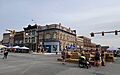
Downtown Xenia
|
|||||
|
|||||
| Nickname(s):
"City of Hospitality", "Bicycle Capital of the Midwest"
|
|||||
| Motto(s):
"Vivid History, Vibrant Future"
|
|||||

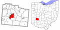
Location of Xenia, Ohio
|
|||||

Xenia, Ohio
Location in Ohio

Xenia, Ohio
Location in the United States
|
|||||
| Country | United States | ||||
| State | Ohio | ||||
| County | Greene | ||||
| Founded | 1803 | ||||
| Area | |||||
| • Total | 13.07 sq mi (33.87 km2) | ||||
| • Land | 13.06 sq mi (33.83 km2) | ||||
| • Water | 0.01 sq mi (0.03 km2) | ||||
| Elevation | 932 ft (284 m) | ||||
| Population
(2020)
|
|||||
| • Total | 25,441 | ||||
| • Density | 1,947.71/sq mi (751.99/km2) | ||||
| • Demonym | Xenian | ||||
| Time zone | UTC-5 (Eastern (EST)) | ||||
| • Summer (DST) | UTC-4 (EDT) | ||||
| ZIP code |
45385
|
||||
| Area code(s) | 937, 326 | ||||
| FIPS code | 39-86772 | ||||
| GNIS feature ID | 1086175 | ||||
| Website | https://www.ci.xenia.oh.us/ | ||||


Xenia (pronounced ZEE-nee-uh) is a city in Ohio, United States. It is the main city, or county seat, of Greene County, Ohio. Xenia is located in southwestern Ohio, about 15 miles east of Dayton. It is part of the larger Dayton area and the Miami Valley region. In 2020, about 25,441 people lived there. The city's name comes from the Greek word Xenia (ξενία), which means "hospitality." This name was chosen because of the friendly welcome people found in the community.
Contents
History of Xenia
.jpg)
.jpg)
Xenia was started in 1803, the same year Ohio became a state. A pioneer named John Paul bought a large piece of land. He convinced county leaders to make this land the county seat. This helped the settlement grow.
Joseph C. Vance then planned the town. He bought the land from John Paul. The town's name was chosen in a meeting. Reverend Robert Armstrong suggested "Xenia," meaning "hospitality" in Greek. This was because of the kindness he felt there. A woman named Laticia Davis cast the deciding vote for "Xenia."
Early Days and Growth
Greene County was created from the Northwest Territory. This area was once home to the Shawnee Indians. Their main village was north of Xenia. The famous Shawnee war chief Tecumseh was born there. Some Catawba also lived near Xenia.
William Beattie opened Xenia's first business, a tavern, in 1804. This tavern became a central place for the community. John Marshall built the first house in 1804. The first school was built in 1805. The town also got its first postmaster that year. Many early businesses came to Xenia, like mills for flour, wood, and wool.
In 1817, Xenia officially became a town. The arrival of the Little Miami Railroad in 1843 helped new businesses grow. It also connected Xenia to other markets. In 1850, the Ohio General Assembly used the new Columbus and Xenia Railroad.
Xenia Springs and Wilberforce University
Starting in 1851, people visited Xenia Springs and Tawawa House. This was a hotel and health spa nearby. It was known for its medicinal springs. Later, this complex became Wilberforce University. This was a historically black college started by the African Methodist Episcopal Church. Many early students were mixed-race children of wealthy white fathers from the South. These fathers wanted their children to get an education.
Modern Improvements and Government
President-Elect Abraham Lincoln visited Xenia briefly in 1861. He gave a short speech from his train.
Xenia grew quickly in the mid-1800s. It got artificial gas in the 1840s and natural gas in 1905. The first fire station was built in 1831. The telephone arrived in 1879, electricity in 1881, and a water system in 1886. Xenia opened its first free public library in 1899. By 1900, the city had its own sewage system.
After the Civil War, the Ohio Soldiers' and Sailors' Orphans' Home was built in Xenia. Parts of it are still used by a Christian group today. Xenia elected its first mayor, Cornelius Clark, in 1834. In 1918, the city changed to a city commission-manager government.
Tornadoes and Recovery
Xenia has a history of strong storms. Some local stories say the Shawnee called the area "the place of the devil wind."

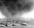
On April 3, 1974, a very powerful F5 tornado hit Xenia. This happened during the 1974 Super Outbreak, one of the biggest tornado events ever. The tornado killed 34 people and injured 1,150. It destroyed almost half of the city's buildings. About 10,000 people lost their homes. Five schools and many businesses were destroyed.
The city's struggles were shown on national news. President Richard Nixon visited Xenia after the disaster. Comedian Bob Hope helped raise money for the city. The new Xenia High School Auditorium was named after him. The Xenia Daily Gazette newspaper won a Pulitzer Prize for its coverage of this tornado.
Xenia was hit by another tornado in 1989 (an F2) and again in 2000 (an F4). The 1989 tornado caused over $2 million in damage. The 2000 tornado killed one person and injured 100. This tornado followed a path similar to the 1974 one.
Today, Xenia has a system of tornado sirens. These sirens warn people when a tornado is coming.
Railroads and Trails
In the past, several railroad lines served Xenia. They carried both goods and passengers. Over time, these lines were no longer used. The last one was removed in 1989.
Many of the old railroad paths have been turned into walking and biking trails. For example, the Little Miami Scenic Trail runs through Xenia.
Xenia also had two interurban railways until the 1940s. These were like electric streetcars that connected cities. As more people bought cars and new highways were built, these railways became less popular.
Geography and Climate
Today, Xenia is located near three major interstate highways: I-70, I-71, and I-75. These highways connect Xenia to many other cities. You can reach them quickly using U.S. Routes 35, 42, and 68. Before the interstate system, U.S. 68 was a main route from Detroit, Michigan. In Xenia, U.S. 68 is called "Detroit Street."
The United States Census Bureau says Xenia covers about 13.29 square miles (34.42 square kilometers). Most of this is land, with a very small amount of water.
Local Weather Patterns
| Climate data for Xenia, Ohio (1991–2020 normals, extremes 1916–present) | |||||||||||||
|---|---|---|---|---|---|---|---|---|---|---|---|---|---|
| Month | Jan | Feb | Mar | Apr | May | Jun | Jul | Aug | Sep | Oct | Nov | Dec | Year |
| Record high °F (°C) | 73 (23) |
77 (25) |
84 (29) |
90 (32) |
95 (35) |
102 (39) |
108 (42) |
107 (42) |
103 (39) |
92 (33) |
84 (29) |
74 (23) |
108 (42) |
| Mean maximum °F (°C) | 59.2 (15.1) |
63.2 (17.3) |
71.7 (22.1) |
80.2 (26.8) |
85.9 (29.9) |
90.2 (32.3) |
91.0 (32.8) |
89.7 (32.1) |
87.7 (30.9) |
82.0 (27.8) |
70.9 (21.6) |
62.3 (16.8) |
92.3 (33.5) |
| Mean daily maximum °F (°C) | 37.6 (3.1) |
41.7 (5.4) |
51.9 (11.1) |
64.8 (18.2) |
73.4 (23.0) |
80.8 (27.1) |
83.4 (28.6) |
82.2 (27.9) |
77.1 (25.1) |
66.1 (18.9) |
53.3 (11.8) |
42.0 (5.6) |
62.9 (17.2) |
| Daily mean °F (°C) | 30.2 (−1.0) |
33.5 (0.8) |
42.7 (5.9) |
54.1 (12.3) |
63.5 (17.5) |
71.4 (21.9) |
74.1 (23.4) |
72.5 (22.5) |
66.6 (19.2) |
55.9 (13.3) |
44.6 (7.0) |
34.9 (1.6) |
53.7 (12.1) |
| Mean daily minimum °F (°C) | 22.7 (−5.2) |
25.2 (−3.8) |
33.6 (0.9) |
43.5 (6.4) |
53.7 (12.1) |
62.0 (16.7) |
64.8 (18.2) |
62.7 (17.1) |
56.1 (13.4) |
45.7 (7.6) |
35.9 (2.2) |
27.9 (−2.3) |
44.5 (6.9) |
| Mean minimum °F (°C) | −1.6 (−18.7) |
4.2 (−15.4) |
13.1 (−10.5) |
25.7 (−3.5) |
37.1 (2.8) |
48.4 (9.1) |
53.3 (11.8) |
50.7 (10.4) |
40.3 (4.6) |
28.5 (−1.9) |
19.1 (−7.2) |
7.8 (−13.4) |
−4.5 (−20.3) |
| Record low °F (°C) | −28 (−33) |
−20 (−29) |
−5 (−21) |
13 (−11) |
25 (−4) |
37 (3) |
42 (6) |
38 (3) |
25 (−4) |
16 (−9) |
−8 (−22) |
−24 (−31) |
−28 (−33) |
| Average precipitation inches (mm) | 3.39 (86) |
2.66 (68) |
3.74 (95) |
4.56 (116) |
4.82 (122) |
4.72 (120) |
3.98 (101) |
3.25 (83) |
2.72 (69) |
3.10 (79) |
3.07 (78) |
3.25 (83) |
43.26 (1,099) |
| Average snowfall inches (cm) | 7.3 (19) |
5.3 (13) |
2.6 (6.6) |
0.5 (1.3) |
0.0 (0.0) |
0.0 (0.0) |
0.0 (0.0) |
0.0 (0.0) |
0.0 (0.0) |
0.1 (0.25) |
0.7 (1.8) |
3.8 (9.7) |
20.3 (52) |
| Average precipitation days (≥ 0.01 in) | 9.8 | 8.4 | 9.2 | 10.7 | 11.0 | 10.3 | 9.1 | 7.2 | 6.2 | 7.6 | 8.3 | 9.1 | 106.9 |
| Average snowy days (≥ 0.1 in) | 3.8 | 3.3 | 1.4 | 0.3 | 0.0 | 0.0 | 0.0 | 0.0 | 0.0 | 0.0 | 0.6 | 2.7 | 12.1 |
| Source: NOAA | |||||||||||||
Population and People
| Historical population | |||
|---|---|---|---|
| Census | Pop. | %± | |
| 1810 | 429 | — | |
| 1820 | 799 | 86.2% | |
| 1830 | 917 | 14.8% | |
| 1840 | 1,913 | 108.6% | |
| 1850 | 3,024 | 58.1% | |
| 1860 | 4,658 | 54.0% | |
| 1870 | 6,377 | 36.9% | |
| 1880 | 7,026 | 10.2% | |
| 1890 | 7,301 | 3.9% | |
| 1900 | 8,696 | 19.1% | |
| 1910 | 8,706 | 0.1% | |
| 1920 | 9,110 | 4.6% | |
| 1930 | 10,507 | 15.3% | |
| 1940 | 10,633 | 1.2% | |
| 1950 | 12,877 | 21.1% | |
| 1960 | 20,445 | 58.8% | |
| 1970 | 25,373 | 24.1% | |
| 1980 | 24,712 | −2.6% | |
| 1990 | 24,664 | −0.2% | |
| 2000 | 24,164 | −2.0% | |
| 2010 | 25,719 | 6.4% | |
| 2020 | 25,441 | −1.1% | |
| 2021 (est.) | 25,463 | −1.0% | |
| Sources: | |||
How Many People Live Here?
In 2010, Xenia had 25,719 people living in 10,390 households. There were 6,631 families. The city had about 1,937 people per square mile.
Most people in Xenia (82.0%) were White. About 13.4% were African American. Other groups included Native American, Asian, and people of two or more races. About 1.7% of the population was Hispanic or Latino.
About one-third of households (32.3%) had children under 18. Most households were married couples (42.6%). Some were led by a female (16.3%) or male (4.9%) without a spouse. About 36.2% were non-families.
The average age in Xenia was 37.1 years. About 24.8% of residents were under 18. About 15.7% were 65 or older. The population was 47.2% male and 52.8% female.
Economy and Jobs
Xenia has been home to several important industries over the years:
- Hooven and Allison rope factory (1870–2003)
- Xenia Shoe Manufacturing
- Xenia Ironcasting Foundry (started 1920)
- Bob Evans Farms meat packing plant
- Kroehler Furniture factory (destroyed in 1974 tornado)
- McDonald Farm Stone Quarry, which provided stone for the Washington Monument
- Dodds Monuments - sculptors for graves and memorials (started 1864)
- Eavey Grocers (1865–1970)
Arts and Culture
The yearly Dayton Hamvention is held at the Greene County Fairgrounds. This event moved to Xenia in 2017. It brings over 20,000 amateur radio fans from all over the world.
Education in Xenia
The Xenia Community School District has several schools:
- Xenia Preschool (for Pre-K students)
- Five elementary schools (Kindergarten to 5th grade): Cox, McKinley, Arrowood, Shawnee, and Tecumseh
- Warner Middle School (6th to 8th grade)
- Xenia High School (9th to 12th grade)
There are also private schools in Xenia:
- Legacy Christian Academy (Pre-K to 12th grade)
- St. Brigid School (Pre-K to 8th grade)
Xenia is also home to the main branch of the Greene County Public Library.
Media and News
Xenia is part of the Dayton media market. This means it gets news and entertainment from the Dayton area.
Newspapers and Online News
The main newspaper in Xenia is the Xenia Daily Gazette, which started in 1868. It is printed two days a week. You can also find local news online at Xenia's Word on the Street. The larger Dayton Daily News also covers Xenia in its printed and online versions.
Radio Stations
Radio stations based in Xenia include:
- 1500 AM WBZI "Real Roots Radio"
- 95.3 FM WZLR "The Eagle" (plays Classic Rock music)
Notable People from Xenia
Many interesting people have come from Xenia, including:
- Doug Adair, a television news anchor
- Doug Adams, an NFL linebacker
- Steve Austria, a U.S. Congressman
- Una Mae Carlisle, a jazz musician
- Dean Chenoweth, a famous racer in the Motorsports Hall of Fame
- Trent Cole, an NFL defensive end
- Charley Grapewin, an actor
- Chris Hero, a professional wrestler
- Roger Huston, a harness race caller
- Roland James, an NFL cornerback
- Tecumseh, a Shawnee Chief during the War of 1812
- Thomas Taggart, a Mayor of Indianapolis and U.S. Senator
- Ridgely Torrence, a poet
Images for kids
-
Downtown Xenia
-

Flag of Xenia
-

Seal of Xenia
-

Logo of Xenia
-
Location of Xenia, Ohio
-
Xenia Station
-
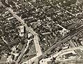
Downtown Xenia in 1930
-
The 1974 Xenia F5 tornado
-

A portion of the Little Miami Scenic Trail in Xenia

See also
 In Spanish: Xenia (Ohio) para niños
