Yazoo Pass expedition facts for kids
Quick facts for kids Yazoo Pass expedition |
|||||||
|---|---|---|---|---|---|---|---|
| Part of the American Civil War | |||||||
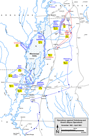
 Operations against Vicksburg and Grant's Bayou Operations.
|
|||||||
|
|||||||
| Belligerents | |||||||
| Commanders and leaders | |||||||
| Units involved | |||||||
| Fort Pemberton garrison | |||||||
| Strength | |||||||
| 8 gunboats 2 rams 1 mortar raft |
2,000 8 guns |
||||||
The Yazoo Pass expedition was a military plan during the American Civil War. It involved both the Union Army, led by Major General Ulysses S. Grant, and the Union Navy, led by Rear Admiral David Dixon Porter. Their goal was to capture the important city of Vicksburg.
Vicksburg was a strong Confederate (Southern) stronghold. It sat on high bluffs next to the Mississippi River. This made it very hard for Union forces to attack directly. So, Grant wanted to find a way to get his soldiers behind the Confederate defenses.
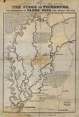
The Yazoo Pass expedition was an attempt to do just that. The plan was to use smaller waterways and rivers behind the main Mississippi River. This route would lead them to the Yazoo River, which flowed into the Mississippi just above Vicksburg. If they could get there, the Union Army could cross the Yazoo River easily and attack Vicksburg from a surprise direction.
This mission needed the Army and Navy to work closely together. The Army was led by Brigadier General Leonard Fulton Ross. The Navy was commanded by Lieutenant Commander Watson Smith. Sadly, Smith was very sick, and his poor health played a big part in why the expedition didn't succeed.
The expedition started on February 3, 1863. Union soldiers broke open a levee (a wall built to hold back water) on the Mississippi River. This allowed water to flow into an old channel. This channel connected to the Yazoo River through a series of other waterways.
The Union ships sailed through this new opening into Moon Lake. From there, they went through the Yazoo Pass into the Coldwater River. Then they entered the Tallahatchie River. The Tallahatchie joins with the Yalobusha River to form the Yazoo River. The Yazoo River then flows back into the Mississippi River, not far from Vicksburg.
Right from the start, the expedition faced many delays. Natural obstacles, like narrow, winding rivers and thick forests, slowed them down. The Confederate forces also put up some resistance, but the natural challenges were much bigger. Sometimes, they moved as little as 10 miles (16 km) in a day.
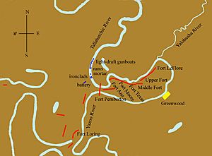
Because they moved so slowly, the Confederate Army had time to build a fort. This fort, called Fort Pemberton, blocked the Union fleet's path near the town of Greenwood, Mississippi. The Union ships didn't reach the fort until March 11. The Union's armored ships, called ironclad gunboats, tried to attack the fort several times. But they were pushed back in a series of battles over three days. The land around the fort was very wet and marshy, so the Union soldiers couldn't help much in the fight.
After the third attack failed on March 16, Lieutenant Commander Smith became too sick to continue. He handed over command to Lieutenant Commander James P. Foster. Foster and General Ross decided to turn back. They were briefly convinced to try again when more Union soldiers arrived. But the new army commander, Brigadier General Isaac Ferdinand Quinby, soon realized that further attacks were pointless. The entire force returned by April 12, and the expedition was over.
Contents
Why the Expedition Happened
The Vicksburg campaign was stuck in early 1863. Union forces had been defeated at Walnut Hills (also known as Chickasaw Bayou) late the year before. Major General Ulysses S. Grant wanted to keep his troops busy. He also wanted to look like he was still actively fighting. So, he ordered several smaller operations. Grant later wrote that he didn't expect these missions to succeed. But he was ready to take advantage if they did. One of these operations was the Yazoo Pass expedition.
The Land and Rivers
The western part of Mississippi is a low, flat area. It's part of the Mississippi Delta, which is the flood plain of the Mississippi River. This area has many marshes, lakes, and rivers. In the past, the Mississippi River would often flood into these smaller waterways. This meant they could be used for travel by boat.
One such route started a bit south of Helena, Arkansas. It went through Moon Lake, which was an old loop of the river that had been cut off. Then it followed the Yazoo Pass to the Coldwater River. The Coldwater River flows into the Tallahatchie River. The Tallahatchie then joins the Yalobusha River to form the Yazoo River at Greenwood, Mississippi. The Yazoo River then flows for about 188 miles (303 km) to rejoin the Mississippi River near Vicksburg.
However, things changed in 1856. Railroads were being built, and the state wanted to drain some land for farming. So, they built artificial levees to keep the Mississippi River in its main channel. This caused the water level in the smaller waterways behind the levee to drop significantly.
Getting Ready
The Army and Navy had slightly different, but connected, goals for this expedition. General Grant wanted his soldiers to reach dry land. He wanted to be on the east side of Vicksburg, without any rivers between his troops and the Confederate defenders. If he could do that, he believed he could attack the Confederate army from the side. He also hoped to send some troops up the Yalobusha River to destroy a railroad bridge. This bridge was important for the Confederates to move supplies.
Admiral Porter's goal was to use his armored gunboats to destroy Confederate ships at Yazoo City. He especially wanted to destroy any enemy ironclads that were being built. Even though their goals were a bit different, this didn't cause problems for the expedition. Other reasons led to its failure.
A quick survey by a naval officer named George W. Brown confirmed the plan seemed possible. So, on February 3, 1863, about 400 soldiers, led by Lieutenant Colonel James H. Wilson, dug two openings in the levee. This was where the old Yazoo Pass used to meet the Mississippi River.
At this time, the Mississippi River was about 8 feet (2.4 m) higher than the old riverbed. So, water rushed through the new openings with great force. It made the gaps bigger and carried away everything in its path. By the next day, the opening was about 80 yards (73 m) wide. The water flow was so strong that the Union ships couldn't safely enter for several days. The fleet of gunboats and army transport ships finally passed through the gap on February 24. They immediately sailed into Moon Lake.
Fighting at Fort Pemberton
The Union fleet finally reached Fort Pemberton on March 11. This was more than five weeks after they had broken the levee at Yazoo Cut. A small group of Union soldiers and the gunboat Chillicothe explored the area. They found that the land near the fort was too swampy for an infantry (foot soldier) attack. This meant the attack would have to be done by the gunboats. They would get some help from any artillery (cannons) that could be brought ashore.
Not all the gunboats could even join the fight. The river was quite narrow, so only two boats could attack at a time. And they could only face the enemy head-on. The first attack was a strong bombardment by Chillicothe and Baron De Kalb. During this fight, Chillicothe was badly damaged. A shell from Fort Pemberton went through one of her gun ports. It hit a shell that was being loaded into an 11-inch (280 mm) gun, causing both to explode. The gun itself was fine, but 14 crew members were killed or wounded. Another man was killed later. Baron De Kalb didn't get much damage because it was built better. Also, the Confederate gunners focused their fire on the weaker Chillicothe.
The next day, March 12, was spent repairing the damaged gunboats. They also added more protection by placing cotton bales on their front decks. Commander Smith also brought two large 30-pounder Parrott cannons ashore. One came from his flagship Rattler and the other from Forest Rose. He also brought a smaller 12-pounder cannon. These cannons were placed about 800 yards (730 m) from the fort. Like the fort's guns, they were protected by cotton bales covered with dirt.
The two ironclads attacked again on March 13. This time, they had help from the cannons on shore and a mortar boat. The Confederate gunners again focused their fire on Chillicothe. She only had three crew members wounded, but the constant pounding from enemy artillery loosened many of her armor plates. This showed that she wasn't built very well. Baron De Kalb, though not hit as hard, lost three officers and men killed and three others wounded.
The Confederates also lost some men. A shell hit their ammunition storage, and though it didn't explode, its fuse set the ammunition on fire. This fire killed one man and burned 15 others. Another shell killed one man and wounded two more. By the end of the day, Fort Pemberton was mostly unharmed. The Union gunboats, especially Chillicothe, were badly beaten. Smith didn't realize that the Confederate fire was slowing down because they were running out of ammunition.
Smith spent the next two days repairing his ships. He also brought an 8-inch (200 mm) gun from Baron De Kalb ashore. He and General Ross decided to make a big attack on Monday, March 16. The plan was for the ironclads to get closer to Fort Pemberton than before. This would help them silence the fort's guns. They would advance side-by-side with the mortar boat tied between them. Union soldiers would follow in smaller ships behind them. They would be ready to land as soon as the fort's guns were knocked out and a good landing spot was found.
But the planned attack quickly fell apart. Several shots or shells hit Chillicothe's armored side. The impact bent the armor plates so much that the gun port covers couldn't be opened. Chillicothe had to pull back. Smith then decided to pull the less damaged Baron De Kalb out of the fight too. This was basically the end of the Union's effort. Smith finally realized that his health was hurting the expedition. So, he gave command to his second-in-command, Lieutenant Commander James P. Foster.
Foster and Ross both decided that trying again would be useless. So, the fleet began to retreat the next day. They hadn't gone far when they met a group of Union ships bringing more soldiers. These reinforcements were led by Brigadier General Isaac Ferdinand Quinby. Quinby was a higher-ranking officer than Ross. Quinby ordered Ross to go back down the river and attack again. He also convinced Foster (whom he couldn't directly order) to go with them.
Over the next few days, they launched a few weak attacks. But Quinby soon found out what Ross already knew: the land was not suitable for an infantry attack. Quinby then received orders from Grant to return to the Mississippi River. Grant needed him and Ross for the next attack on Vicksburg. The fleet left Fort Pemberton for the last time. By April 14, all the ships had returned, and the expedition was officially over.
Images for kids
 | Kyle Baker |
 | Joseph Yoakum |
 | Laura Wheeler Waring |
 | Henry Ossawa Tanner |


