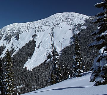
Zupjok Peak facts for kids
Quick facts for kids Zupjok Peak |
|
|---|---|

Zupjok Peak, south aspect
|
|
| Highest point | |
| Elevation | 1,835 m (6,020 ft) |
| Prominence | 110 m (360 ft) |
| Parent peak | Alpaca Peak (2083 m) |
| Geography | |
| Location | British Columbia, Canada |
| Parent range | North Cascades |
| Topo map | NTS 92H/11 |
| Climbing | |
| Easiest route | Off-trail hiking via south slope |
Zupjok Peak is a mountain in British Columbia, Canada. It stands 1,835 meters (about 6,020 feet) tall. This peak is part of the North Cascades mountain range. It is found near the Coquihalla Summit Recreation Area in southwestern British Columbia.
The peak is located north of the Coquihalla Highway. It is also about 6 kilometers (4 miles) west of Coquihalla Summit. Another nearby peak, Alpaca Peak, is about 4 kilometers (2 miles) to its north. Rain and melting snow from Zupjok Peak flow into the Coldwater River. They also feed into parts of the Coquihalla River and Anderson River.
The mountain's name, Zupjok, comes from a special animal. A "zupjok" is the name for a male offspring of a bull and a female yak. This name fits a theme of using animal names for several peaks in the area. Philip Kubik of Vancouver suggested the name. The Canadian government officially adopted the name on February 5, 1976.
Contents
How Zupjok Peak Was Formed
The Story of Glaciers
Over two million years ago, during the Pleistocene period, huge sheets of ice called glaciers covered the land. These glaciers moved slowly, scraping and shaping the landscape. They left behind piles of rock and dirt.
When these glaciers melted and moved away, they carved out deep valleys. Many river valleys in this area have a "U" shape. This special shape is a clue that glaciers once moved through them.
Mountains and Valleys
The North Cascades area has very rugged land. It features sharp peaks, long ridges, and deep valleys. These valleys were carved by glaciers. There are also tall, pointed rock formations made of granite.
The tall peaks and deep valleys were created by two main forces. First, the land was pushed up by geological events. This process is called orogeny. Second, large cracks in the Earth's crust, called faults, also helped shape the land. These forces, combined with the action of glaciers, created the dramatic scenery we see today.
The different heights and shapes of the land also lead to different climates. These climate changes then create various types of plant life. This is how different ecoregions are formed in the area.
Weather and Climate Around Zupjok Peak
Understanding the Climate Zone
Zupjok Peak is in a special climate zone called the marine west coast climate. This type of climate is common in western North America. It means the area gets a lot of moisture from the ocean.
How Weather Works Here
Most of the weather systems start over the Pacific Ocean. They then travel east towards the Cascade Range. When these weather systems hit the mountains, they are forced to rise. This process is called Orographic lift. As the air rises, it cools down and drops its moisture.
This is why the Cascade Mountains get a lot of rain or snow. Winters, especially, see heavy snowfall. Temperatures can get very cold, sometimes dropping below −20 °C (which is about −4 °F). With wind, it can feel even colder, below −30 °C (about −22 °F).
Best Time to Visit
If you want to climb Zupjok Peak, the best time to go is during the summer. The months of July, August, and September usually have the nicest weather. This makes it safer and more enjoyable for hiking.
 | Shirley Ann Jackson |
 | Garett Morgan |
 | J. Ernest Wilkins Jr. |
 | Elijah McCoy |


