
Zócalo facts for kids
| Plaza de la Constitución | |
_(cropped).jpg)
Plaza de la Constitución
|
|
| Coordinates | 19°25′58″N 99°7′59″W / 19.43278°N 99.13306°W |
|---|---|
| Location | Cuauhtémoc, Mexico City, Mexico |
| Beginning date | 1521 |
| Completion date | 1523 |
| Opening date | 1524 |
The Zócalo is the huge main public square located in the historic center of Mexico City. Its official name is the Plaza de la Constitución (Constitution Square). Long before modern times, it was the ceremonial center of the ancient Aztec capital city named Tenochtitlan. Today, it serves as the beating heart of Mexico, welcoming millions of visitors, cultural celebrations, and national gatherings every year.
Covering a massive area of nearly 60,000 square meters, the Zócalo ranks among the largest city squares worldwide. Grand historic structures enclose the plaza on all four sides. These buildings represent centuries of Mexican architecture, politics, and community life. In the middle flies an enormous Mexican flag, raised and lowered daily with great ceremony.
Contents
- What Makes the Zócalo Special?
- The Ancient Aztec Origins of the Square
- Colonial Transformation Under Spanish Rule
- The Nineteenth Century: Revolution and Turmoil
- The Modern 20th Century: Concrete, Preservation, and Renewal
- Historic Buildings Surrounding the Plaza
- The Heart of Mexican Politics and Civic Voice
- A Dynamic Stage for Art, Music, and Sports
- Summary: The Beating Heart of a Nation
- See Also
- Images for kids
What Makes the Zócalo Special?
The Zócalo has served as a central meeting ground for roughly 700 years. Few public plazas on Earth boast such continuous community history. It stands right beside the archaeological remains of the Templo Mayor, once seen by the Aztecs as the spiritual center of the universe.
Size, Layout, and Famous Landmarks
The plaza forms an almost perfect rectangle measuring 240 meters by 240 meters (about 787 feet on each side). That creates an open space of 57,600 square meters. It easily accommodates over 100,000 people during massive cultural festivals and civic assemblies.
Four distinct landmarks border the plaza:
- To the north stands the towering Mexico City Metropolitan Cathedral, built out of ancient carved stones.
- To the east sits the expansive National Palace, housing offices of the federal executive branch.
- To the south rise the twin colonial-style Federal District buildings, serving as Mexico City's municipal headquarters.
- To the west line the historic Portal de Mercaderes arcade buildings, packed with shops, hotels, and restaurants.
At the northwest corner rests the historic Nacional Monte de Piedad, a famous charitable pawnshop founded in 1775. Just off the northeast corner, visitors can explore the excavated stone ruins of the sacred Aztec temple precinct. Beneath the northeast corner, commuters access the busy Zócalo/Tenochtitlan metro station network.

How the Square Got Its Name
During Spanish colonial rule, people referred to this place simply as the Plaza Mayor (Main Square) or Plaza de Armas (Weapons Square). In 1813, officials officially named it Plaza de la Constitución. Surprisingly, this did not honor a Mexican constitution. Instead, it honored Spain's liberal Cádiz Constitution signed during the Napoleonic Wars.
Why do locals call it the "Zócalo"? In Spanish architecture, a zócalo refers to a stone base or plinth built to support a monument. In 1843, Mexican President Antonio López de Santa Anna planned a grand independence column in the center. Workers built only the round stone base before funding dried up.
That empty stone base sat alone in the square for decades. People arranged meetings by saying, "Meet me at the zócalo." The base was eventually buried beneath paving stones, but the nickname stuck forever. Today, towns across Mexico use the word zócalo when referring to their central squares.
The Ancient Aztec Origins of the Square

Long before Spanish ships sailed to the Americas, the Mexica people (often called Aztecs) built a thriving civilization on an island in Lake Texcoco. Their great capital city was Tenochtitlan, founded around 1325.
The Island Capital of Tenochtitlan
Tenochtitlan was a marvel of pre-Columbian civil engineering. Aztec engineers built artificial islands called chinampas to farm crops on shallow lake waters. They constructed raised earthen roads called causeways to connect the island to the mainland. Aqueducts carried fresh spring water straight from the hills of Chapultepec right into urban neighborhoods.
The area where the Zócalo sits today was an open public expanse south of the main sacred temple district. To the east stood the grand palace of Emperor Moctezuma II, known as the "New Houses." To the west stood the palace of his predecessor, Emperor Axayacatl, called the "Old Houses."
The Intersection of Four Worlds
Tenochtitlan was divided into four major sectors or quarters called campans, made up of smaller neighborhood units known as calpullis. Two massive paved avenues crossed right near the present-day Zócalo:
- The North-South road connected the northern shrines of Tepeyac down toward southern towns like Iztapalapa.
- The East-West road linked the western shore city of Tlacopan (now Tacuba) to the lake docks in the east.
Spanish explorer Hernán Cortés noted that these avenues were as wide as three jousting lances. The intersection served as a natural gathering point for neighborhood leaders, traders, and temple visitors.
The Sacred Precinct and the Templo Mayor
Just northeast of this intersection stood a high wall decorated with carved stone serpents. Inside lay the sacred precinct, dominated by the massive Templo Mayor pyramid. The Aztecs believed this twin-templed pyramid was the spiritual center of the universe.
One shrine at the summit honored Tlaloc, the god of rain and agricultural fertility. The second shrine honored Huitzilopochtli, the god of sun and warfare. Common citizens gathered in the open space outside the sacred walls during seasonal festivals to hear announcements from the emperor.
Colonial Transformation Under Spanish Rule
In 1521, Spanish forces and their indigenous allies conquered Tenochtitlan after a prolonged siege. The island metropolis lay in ruins, marking the beginning of three centuries of colonial rule.
Designing a New Capital
Hernán Cortés chose to rebuild the colonial capital directly atop the Aztec ruins. A royal surveyor named Alonso García Bravo designed the new street grid using classic Renaissance principles. He kept the four Aztec avenues to divide the city, ensuring the historic intersection remained central.
Cortés took the land where Moctezuma's palace had stood to build his viceregal headquarters, which evolved into today's National Palace. At the northern end of the space, Spanish friars began assembling a modest Christian church. They used stone blocks salvaged from the ruined Aztec temples to build the church's walls.
The open space was split into two halves: the larger southern Plaza Mayor and a northern open area called the Plaza Chica. As the colonial city expanded rapidly, private buildings soon covered the small northern square, making the Main Square the undisputed focus of civic life.
Tackling Floods: The Great Desagüe
Because Mexico City sat inside an enclosed mountain basin with no natural river outlets, heavy summer rains regularly flooded the colonial streets. The square suffered disastrous inundations throughout the sixteenth and seventeenth centuries.
A major flood hit the city in 1629. Water submerged the central square up to two meters deep for nearly five years. Merchants conducted business entirely from wooden canoes, and several stone structures cracked and collapsed.
To solve this continuous crisis, colonial officials launched an ambitious drainage project known as the desagüe. Thousands of indigenous laborers were drafted to dig massive tunnels and drainage canals through northern mountain passes. Controlling the floodwaters protected homes and helped limit the spread of waterborne diseases. However, draining the ancient lake system gradually altered the local ecosystem, drying out wetlands that had supported wildlife and traditional agriculture for centuries.
The Bustling Parián Market

During the 1600s, the plaza transformed into an open-air marketplace filled with wooden booths, food stands, and livestock corrals. Following a civic riot in 1692 that damaged the Viceregal Palace, officials decided to build a proper covered market to organize local trade.
In 1703, builders completed the Parián, a massive stone bazaar constructed in the southwestern quadrant of the square. It took its name from the Chinese merchant district in Manila, the capital of the Spanish Philippines.
The Parián functioned as the primary trade center for luxury goods arriving on Spanish trading ships called the Manila galleons:
- Silk, porcelain, spices, and lacquerware arrived from Asian trading ports via Acapulco.
- Fine glassware, textiles, books, and metal tools arrived from European ports via Veracruz.
For over a century, the Parián was considered one of the richest commercial centers in the Western Hemisphere. Rent collected from shopkeepers provided substantial funds for city improvements.
Unearthing Ancient Aztec Treasures

In 1789, a reform-minded viceroy named Juan Vicente Güemes, the Count of Revillagigedo, initiated a comprehensive modernization of the plaza. He ordered all disorderly market stalls outside the Parián removed. Workers leveled the uneven dirt floor, paved the square with cut stone, and installed Mexico City's first 64 street lanterns.
While digging drainage trenches in late 1790, workers hit carved stone surfaces beneath the paving stones. On 13 August 1790, they unearthed the colossal statue of Coatlicue, the Aztec earth-mother goddess. Four months later, on 17 December 1790, excavators discovered the famous 24-ton Aztec calendar stone (Sun Stone).
Instead of destroying these pre-Hispanic artifacts, scholars preserved them. The Aztec Calendar was mounted on the exterior western tower of the Metropolitan Cathedral, where pedestrians studied its detailed astronomical carvings for a century. Today, both treasures occupy places of honor inside the world-famous Museo Nacional de Antropología.
The Count also commissioned architect Manuel Tolsá to cast a magnificent bronze monument of King Charles IV. The heavy statue was inaugurated in the plaza in December 1803 atop a marble oval base.
The Nineteenth Century: Revolution and Turmoil
The nineteenth century brought dramatic political upheaval to Mexico, transforming the square from a Spanish colonial plaza into a symbol of an independent nation.
War of Independence and the 1828 Riot

In 1821, Mexican rebel armies triumphed, ending three centuries of Spanish rule. The newly independent government promptly ordered the bronze statue of King Charles IV removed from the Zócalo. Officials recognized its artistic craftsmanship, so they moved it out of public sight to a university courtyard; today it stands outside the Museo Nacional de Arte.
The square remained politically volatile. In December 1828, political disputes sparked widespread civil unrest known as the Parián Riot. Crowds broke into the market shops, leading to widespread property destruction and economic losses for international merchants.
Recognizing that the old shopping center attracted unrest, President Antonio López de Santa Anna had the entire Parián complex demolished in 1843. This completely cleared the plaza's center, leaving open land where his famous unfinished monument base soon gave the square its lasting name: the Zócalo.
The Garden Era of the Porfiriato

During the 1860s, city planners transformed the dusty plaza into a landscaped public park known as the Paseo del Zócalo. Gardeners laid out curving pathways, planted flowering ash trees, set up cast-iron benches, and installed decorative water fountains.
In 1878, a philanthropist named Antonio Escandón gifted an ornate iron music kiosk to the city. Workmen erected the bandstand directly atop Santa Anna's old monument base. The kiosk featured gas lighting inspired by modern Parisian parks.
During the long presidency of Porfirio Díaz (a period called the Porfiriato, 1876–1911), Mexico City invested heavily in modern transportation:
- In the late 1880s, tracks were laid around the square for mule-drawn streetcars.
- In 1891, the dirt walkways were repaved with smooth asphalt.
- In 1894, engineers installed electric streetlamps and replaced the mule cars with electric trolley lines.
The Zócalo turned into the central transit terminal for the capital. Commuters caught streetcars from the plaza to suburban neighborhoods like Coyoacán, San Ángel, and Tacubaya.
The Modern 20th Century: Concrete, Preservation, and Renewal
The twentieth century brought sweeping visual and functional changes to the Zócalo. It shifted away from a quiet Victorian garden into a massive stone forum for civic expression.
From Green Park to Vast Open Esplanade

In February 1913, the National Palace suffered artillery damage during a turbulent ten-day conflict known as the Decena Trágica. The gardens inside the square were trampled, and mature ash trees were damaged.
In 1914, city authorities redesigned the landscape. They removed older deciduous trees and planted tall Mexican fan palms in each quadrant. Through the mid-twentieth century, as vehicle traffic surged, the plaza's edges were turned into parking spots for hundreds of cars and buses.
By the early 1970s, the city government chose to fundamentally redesign the plaza:
- Workers tore out the streetcar tracks and removed all parking stalls.
- Garden beds and palm trees were removed to open up sightlines.
- Crews covered the entire 57,600-square-meter surface with poured concrete and pink-toned cobblestone pavers.
- A single, towering 50-meter steel flagpole was raised dead-center.
This created the massive open stone plain we recognize today, capable of holding immense gatherings without damaging garden plants.
Rediscovering the Templo Mayor
On 21 February 1978, utility workers digging trenches at the corner of Guatemala and Argentina streets hit a massive carved stone disc. The carving depicted Coyolxauhqui, the Aztec moon goddess.
This discovery launched a major archaeological project led by archaeologist Eduardo Matos Moctezuma. Over several years, archaeologists carefully excavated the foundations of the ancient Templo Mayor. They uncovered multiple layered pyramids, ritual offering caches, and stone carvings dating back to the Aztec empire. Today, this open-air archaeological park and museum sits immediately adjacent to the northeast corner of the Zócalo.
Major Restorations in the 1990s
By the late twentieth century, decades of heavy traffic, sinking lakebed foundations, and air pollution caused severe wear across the historic downtown area.
In 1997, the city government partnered with private foundations to launch an ambitious $300 million preservation campaign. Engineers repaired the sinking foundations of the Metropolitan Cathedral, cleaned centuries of soot from colonial stone facades, buried unsightly overhead electrical cables, and repaved pedestrian paths. These efforts helped ensure the historic center, named a UNESCO World Heritage Site in 1987, remained protected for future generations.
Historic Buildings Surrounding the Plaza
Each structure enclosing the Zócalo represents an important chapter in Mexican history and architecture.
The Metropolitan Cathedral
Dominating the northern edge of the square sits the Mexico City Metropolitan Cathedral, the largest church in the Americas. Construction began in 1573 under architect Claudio de Arciniega and took over 240 years to finish, wrapping up in 1813.
Because construction lasted across two centuries, the cathedral blends several major architectural styles:
- Gothic: Visible in ribbed vaulting inside the earliest side chapels.
- Baroque: Highlighted by elaborately carved stone facades and gold-leaf altars, including the famous Altar of the Kings.
- Neoclassical: Showcased in the symmetrical clock towers and exterior stone domes designed by Manuel Tolsá.
The massive weight of the stone cathedral caused it to sink unevenly into the soft, spongy lakebed clay beneath the city. In the 1990s, civil engineers carried out an engineering project called sub-excavation. They drilled deep underneath the cathedral to remove pockets of mud, successfully leveling the structure and preventing its towers from collapsing.
The National Palace (Palacio Nacional)
Taking up the entire eastern border of the Zócalo is the National Palace. Stretching over 200 meters in length, this grand building stands on the site of Moctezuma II's palace and Hernán Cortés's original colonial mansion.
Its outer walls are surfaced with red volcanic stone called tezontle, trimmed with white quarry stone and wrought-iron window grilles. Inside, sweeping stairwells and open courtyards feature famous frescoes painted by world-renowned muralist Diego Rivera between 1929 and 1935. Rivera's murals depict Mexico's complex history, celebrating ancient indigenous arts, exploring the colonial era, and highlighting modern social reforms.
The Old Portal de Mercaderes
Running along the western boundary are the covered walkways of the Portal de Mercaderes. Since the 1520s, merchants have leased these shaded arcades to sell crafts, clothing, confections, and books.
Today, upper levels house hotels and open-air rooftop restaurants. From these balconies, visitors enjoy views across the open plaza, the cathedral facade, and the National Palace.
The Federal District City Halls
Two symmetrical buildings anchor the southern edge of the square, serving as the seat of local municipal government.
The building on the southwest corner is the historic Old City Hall (Antiguo Palacio del Ayuntamiento), originally constructed in the 1530s and rebuilt in the 1720s. Its facade features hand-painted ceramic tiles celebrating founding dates of Mexican cities. The matching building to its east was constructed in the 1940s to blend in with the colonial architecture surrounding the plaza.
The Heart of Mexican Politics and Civic Voice

Because it stands directly outside the offices of national and city leadership, the Zócalo has long served as the country's central forum for peaceful civic assemblies, public demonstrations, and national rallies.
Whenever Mexican citizens wish to voice their opinions on elections, human rights, worker benefits, or environmental preservation, they gather in the Zócalo. Large public movements assemble here, highlighting the community's constitutional right to assemble peacefully.
The Independence Day "Grito" Ceremony
The most famous annual civic event occurs on the night of 15 September: the celebration of the Grito de Dolores (Cry of Dolores). This ceremony commemorates the night in 1810 when Catholic priest Miguel Hidalgo y Costilla rang church bells in the town of Dolores, calling on citizens to rise up for Mexican freedom.
Shortly before 11:00 p.m., tens of thousands of citizens gather in the brightly illuminated square. The President of Mexico steps out onto the central balcony of the National Palace. Holding the Mexican flag, the president rings Hidalgo's original bell and recites the traditional words honoring revolutionary heroes, ending with a passionate shout: "¡Viva México!"
The crowd roars "¡Viva!" back in unison. The ceremony concludes with the national anthem, ringing cathedral bells, and a spectacular fireworks display filling the night sky.
A Dynamic Stage for Art, Music, and Sports
Beyond politics, the Zócalo serves as an open-air public venue for art, concerts, athletic tournaments, and seasonal celebrations.
Indigenous Aztec Dancers

Every week of the year, indigenous dancers known as concheros gather near the northeast corner of the Zócalo. Wearing feathered headdresses, tunics, and rattles crafted from dried seed pods and shells around their ankles, they perform ceremonial dances.
The rhythmic beat of wooden huehuetl drums echoes across the stone floor. Performers burn aromatic copal tree resin in clay incense burners, cleansing passersby and celebrating ancestral Mexica traditions right beside the ancient ruins of Tenochtitlan.
World-Record Free Concerts
The open layout makes the Zócalo one of the premier open-air concert venues on the planet. The city frequently organizes free public concerts featuring global superstars to bring high-quality music directly to all citizens:
- In 2005, beloved Mexican rock band Café Tacvba drew roughly 100,000 spectators.
- In 2007, international pop star Shakira performed before an estimated 210,000 fans.
- In May 2012, legendary songwriter Paul McCartney drew a massive crowd of 250,000 during his tour.
- In July 2012, Canadian singer Justin Bieber played to 210,000 cheering youth.
- In October 2016, classic rock musician Roger Waters performed for 170,000 people.
- In June 2023, the Argentine rock group Los Fabulosos Cadillacs broke attendance records when over 300,000 music fans packed the plaza and surrounding pedestrian streets.
The Spectacular Day of the Dead Celebrations

In late October and early November, the Zócalo transforms for the Day of the Dead (Día de los Muertos). Artisans from across Mexico erect massive ceremonial altars (ofrendas) decorated with fragrant orange cempasúchil (marigold) blossoms, sugar skulls, and cut paper banners.
Since 2016, the square has also served as the finish line for the grand Day of the Dead Carnival Parade. Hundreds of thousands of families pack the streets to marvel at giant skeleton puppets, colorful floats, and traditional dancers dressed as elegant Catrinas.
Winter Festivities, Sports, and Global Events
During the winter holidays, city workers string thousands of energy-efficient LED lights along surrounding municipal facades, illuminating whole city blocks in colorful glowing murals. In previous years, the plaza hosted an enormous temporary artificial ice-skating rink, letting tropical-climate residents enjoy free ice skating.
The Zócalo also celebrates major athletic achievements. On 15 March 2026, the square made sports history by hosting the world's largest football (soccer) training class, attended by 9,500 enthusiastic young athletes. Later that summer, the square held an official FIFA Fan Festival for the 2026 FIFA World Cup, welcoming hundreds of thousands of international fans to watch matches on giant television screens in the shadow of ancient Aztec ruins and colonial cathedrals.
Summary: The Beating Heart of a Nation
From its ancient beginnings as an open expanse beside the Aztec Templo Mayor to its role today as a world-famous gathering place, the Zócalo remains an enduring symbol of Mexico. Within this single grand square, seven centuries of indigenous engineering, colonial architecture, independent revolution, and modern culture stand side by side, making it one of the most vibrant urban gathering spaces on Earth.
See Also
- Templo Mayor
- Mexico City Metropolitan Cathedral
- National Palace (Mexico)
- Tenochtitlan
- History of Mexico City
Images for kids
-
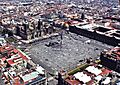
The wide stone expanse of the modern Zócalo.
-
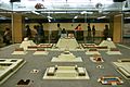
A scale model of the Aztec Templo Mayor precinct.
-
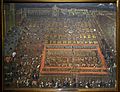
The Plaza Mayor painted by Cristóbal de Villalpando in 1695.
-
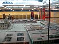
Scale model of the square with the historic Parián market.
-
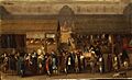
The colonial Parián Market in the 1700s.
-
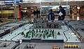
Scale model of the garden paths around 1910.
-
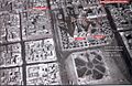
Historic aerial photograph of the square taken around 1920.
-
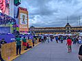
The square hosting a major FIFA public sports celebration.
-
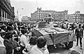
A public assembly of citizens gathered in the plaza in 1968.
-

An indigenous dancer in regalia dancing near the cathedral.
