
2025 Atlantic hurricane season facts for kids
| First storm formed | June 23, 2025 |
|---|---|
| Last storm dissipated | Season ongoing |
| Strongest storm | Erin – 993 mbar (hPa) (29.34 inHg), 75 mph (120 km/h) (1-minute sustained) |
| Total depressions | 5 |
| Total storms | 5 |
| Hurricanes | 1 |
| Major hurricanes (Cat. 3+) | 0 |
| Total fatalities | 23 total |
| Total damage | > $61.97 million (2025 USD) |
| Atlantic hurricane seasons 2023, 2024, 2025, 2026, 2027 |
|
| Related article | |
|
|
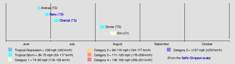
The 2025 Atlantic hurricane season is currently happening in the Northern Hemisphere. This special time of year, when most tropical storms form in the Atlantic Ocean, officially started on June 1 and will end on November 30. The first storm, Tropical Storm Andrea, appeared on June 23. This was the latest start to an Atlantic hurricane season since 2014.
Contents
Understanding Atlantic Hurricane Seasons
What Are Hurricane Forecasts?
Before and during each hurricane season, experts try to predict how many storms will form. These predictions come from groups like the United States National Oceanic and Atmospheric Administration (NOAA), Tropical Storm Risk (TSR), the United Kingdom's Met Office, and Colorado State University (CSU). They look at many things that can affect how many tropical storms, hurricanes, and major hurricanes might happen.
For example, between 1991 and 2020, an average hurricane season had about 14 named storms, 7 hurricanes, and 3 major hurricanes. Major hurricanes are very strong storms, like Category 3 and higher on the Saffir–Simpson scale.
How We Measure Storm Power (ACE)
One way experts measure how active a hurricane season is by using something called the Accumulated Cyclone Energy (ACE) index. ACE measures the total power of all tropical storms and hurricanes over their lifetime. It's only calculated for storms that reach wind speeds of 39 mph (63 km/h) or higher. NOAA often describes a season as above-average, average, or below-average based on this ACE index, as well as the number of storms.
Before the season began, and as it continued, different groups shared their predictions. For instance, Colorado State University (CSU) thought it would be an above-average season because the Atlantic Ocean waters were very warm. They also noted that La Niña, a weather pattern, was weakening.
The 2025 Hurricane Season So Far
How the Season Began
The 2025 Atlantic hurricane season officially started on June 1. So far, five tropical storms have formed, and one of them became a hurricane. The National Hurricane Center (NHC) calculates the ACE index for the season. As of August 15, the ACE index is about 7.8 units. This number helps us understand the total energy of the storms that have formed.
Early Challenges for Storms
The first storm, Tropical Storm Andrea, formed on June 23. This was three weeks after the official start of the season. It was also later than usual for the first named storm to appear.
At the beginning of the season, it was hard for storms to form. A large area of high pressure in the Atlantic pushed early tropical waves, which are like ripples in the atmosphere, further south than usual. This sent them towards Central America and the Pacific Ocean. Also, a lot of dry Saharan dust was blowing across the Atlantic, which can stop storms from growing.
First Storms of the Season
Tropical Storm Andrea stayed over the open ocean. The next storm, Tropical Storm Barry, formed on June 28 in the Bay of Campeche. It made landfall near Tampico in Mexico the next day.
The third storm, Tropical Storm Chantal, formed off the coast of the southeastern United States on July 4. Chantal made landfall two days later in South Carolina. The first three storms of the year were short-lived.
Mid-Season Activity
After a quiet period of almost a month, Tropical Storm Dexter formed on August 4 off the North Carolina coast and moved out to sea. Then, Hurricane Erin formed near Cabo Verde on August 11. Erin traveled across the Atlantic and became the first hurricane of the season on August 15.
Meet the Storms of 2025
Tropical Storm Andrea
| Tropical storm (SSHS) | |||
|---|---|---|---|
|
|||
| Duration | June 23 – June 24 | ||
| Intensity | 40 mph (65 km/h) (1-min), 1014 mbar (hPa) | ||


On June 22, experts started watching an area of low pressure east-southeast of Bermuda. It had the potential to become a tropical storm. This low pressure area was part of a fading weather front. It became more organized, and a tropical depression formed on June 23. Andrea reached its strongest point with winds of 40 mph (65 km/h) on June 23. Andrea weakened quickly and became a non-tropical low by June 24. It completely disappeared by June 25.
Tropical Storm Barry
| Tropical storm (SSHS) | |||
|---|---|---|---|
|
|||
| Duration | June 28 – June 30 | ||
| Intensity | 45 mph (75 km/h) (1-min), 1006 mbar (hPa) | ||


On June 27, a large area of low pressure formed over the Yucatán Peninsula. As it moved into the Bay of Campeche, it became more organized and was named Tropical Storm Barry on June 29. Barry moved northwest, but strong winds kept it from getting much stronger. That same evening, Barry weakened and made landfall south of Tampico, Tamaulipas, Mexico. Its winds were about 30 mph (48 km/h). Barry soon faded away over the mountains of northeastern Mexico.
The weather system that created Barry caused significant flooding and damage in Quintana Roo, Mexico. Water levels rose, and heavy rain led to landslides in Chiapas. In Belize, there was also severe damage to buildings and roads, with widespread flooding. Sadly, in Veracruz, two people died after being swept away by rough water. In Santa María del Río, two young people died when their motorcycle was swept away by a flooded river. Another person in Matamoros also died due to flooding. In total, 8 lives were lost because of Barry.
Tropical Storm Chantal
| Tropical storm (SSHS) | |||
|---|---|---|---|
|
|||
| Duration | July 4 – July 7 | ||
| Intensity | 60 mph (95 km/h) (1-min), 1002 mbar (hPa) | ||


On June 29, experts began watching a weather system near the southeastern United States coast. On July 4, a weak low-pressure area formed off the coast of Florida. The ocean waters were warm, helping the system to grow. It became Tropical Depression Three, and then Tropical Storm Chantal on July 5. Chantal moved north, strengthening to 50 mph (80 km/h) winds. It made landfall near Litchfield Beach, South Carolina, on July 6. The storm then moved inland, weakening to a tropical depression. A day later, Chantal changed into a post-tropical cyclone over northern Virginia.
In Florida, some Fourth of July events were canceled because of the rain from Chantal. When Chantal hit South Carolina, winds reached 56 mph (90 km/h) in Myrtle Beach. In North Carolina, heavy rains of 7–8 inches (180–200 mm) caused flooding and power outages. Orange County declared a state of emergency due to flash flooding, and over 50 water rescues took place. A small tornado damaged two airplanes and two hangars at Raleigh Executive Jetport. In Durham County, North Carolina, rescue teams performed over eighty boat rescues. Sadly, six people died in North Carolina due to the flooding.
Tropical Storm Dexter
| Tropical storm (SSHS) | |||
|---|---|---|---|
|
|||
| Duration | August 4 – August 7 | ||
| Intensity | 50 mph (85 km/h) (1-min), 998 mbar (hPa) | ||


On August 2, a non-tropical low-pressure area formed off the coast of North Carolina. By August 3, it started to produce strong winds and thunderstorms. It soon gained tropical features and became Tropical Storm Dexter. Dexter formed about 300 miles (480 km) west-northwest of Bermuda. Strong winds in the upper atmosphere made it hard for Dexter to strengthen at first. However, it still managed to reach winds of 45 mph (75 km/h). Dexter then changed into a non-tropical storm on August 7 as it merged with another weather system.
Hurricane Erin
| Category 1 hurricane (SSHS) | |||
|---|---|---|---|
|
|||
| Duration | August 11 – Present | ||
| Intensity | 75 mph (120 km/h) (1-min), 993 mbar (hPa) | ||


On August 9, a tropical wave moved off the west coast of Africa. By August 10, a low-pressure area formed near the Cape Verde Islands. On the morning of August 11, this system organized into Tropical Storm Erin, with winds of about 40 mph (65 km/h). Erin moved quickly west, but it faced conditions that made it hard to grow stronger. Despite this, Erin was able to strengthen into a Category 1 hurricane on the morning of August 15.
In Cape Verde, there was heavy rainfall on São Vicente island on August 11. This caused widespread flooding and damage to homes and roads. The Cape Verde government declared a disaster for São Vicente and Santo Antão islands. Five people were reported missing, and 1,500 people had to leave their homes. Sadly, nine people died due to the flooding.
Naming Hurricanes
The names used for storms in the North Atlantic in 2025 are the same as those used in the 2019 season. The only change is Dexter, which replaced Dorian. This season is the first time the name Dexter has been used.
|
|
|
The Season's Impact
This table shows all the storms that have formed in the 2025 Atlantic hurricane season so far. It includes how long they lasted, their names, how strong they were, the areas they affected, the damage they caused, and the total number of deaths. Deaths in parentheses mean they were indirectly related to the storm, like a traffic accident during bad weather. All damage costs are in 2025 US dollars.
