
A4200 road facts for kids
Quick facts for kids
|
||||
|---|---|---|---|---|
| Lua error in Module:Infobox_road/map at line 15: attempt to index field 'wikibase' (a nil value). | ||||

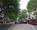
A4200 Kingsway from the south in 2009
|
||||
| Route information | ||||
| Length | 2.0 mi (3.2 km) | |||
| Major junctions | ||||
| South end | A4 Aldwych | |||
|
||||
| East end | A400 Camden High Street, next to Mornington Crescent tube station | |||
| Highway system | ||||
Template:Infobox road/browselinks/ENG
|
||||

The A4200 is an important road in central London. It connects the A4 at Aldwych to the A400 Hampstead Road and Camden High Street. This meeting point is near Mornington Crescent tube station. The road passes through areas like Holborn, Bloomsbury, Euston, and Somerstown.
Contents
Kingsway: A Famous London Road


Kingsway is a major road in central London. It is part of the A4200 route. Kingsway starts at High Holborn in the north, which is in the London Borough of Camden. It ends at Aldwych in the south, near Bush House in the City of Westminster.
King Edward VII officially opened Kingsway in 1905. Kingsway and Aldwych together form a key north-south route in central London. They link the old east-west roads of High Holborn and Strand. The name "King's Way" was first used for Theobalds Road. This was the route King James I took when traveling from London to his home, Theobalds Palace.
How Kingsway Was Built
Creating a New Road
Kingsway was specially built as part of a big project in the early 1900s. Its creation removed many small, crowded streets in Holborn. It also replaced old, crowded houses in the area. However, Holy Trinity Church, which was on Little Queen Street, was saved. But the Sardinian Embassy Chapel, an important Roman Catholic church, was taken down to make way for the new street.
The London County Council shared their plans in 1898. The road was officially opened in 1905. Kingsway is one of the widest streets in central London, measuring about 30 meters (100 feet) across. Many names were suggested for the new street. These included King Edward VII Street and Empire Avenue. The name "Kingsway" was chosen to honor King Edward VII, who opened the street.
The Tramway Tunnel
Kingsway was special because it had a tunnel underneath it for trams. This tunnel started north of Southampton Row. It went under Aldwych and continued to the Thames Embankment. This Kingsway tramway subway connected the tram systems of North and South London.
In 1958, the old tram tunnel was reopened at its southern end. It became a new connection called the Strand Underpass. This underpass helps light traffic move between Waterloo Bridge and Kingsway. This helps reduce traffic jams. Also under Kingsway was a branch of the Piccadilly tube line. It ran from Holborn to Aldwych station on the Strand. This tube line closed in 1994. Aldwych station is still used for TV and film sets that need underground scenes. During the Second World War, this branch was used to store valuable art from the British Museum. This included the famous Elgin Marbles.
2015 Underground Fire
On April 1, 2015, electrical cables under the pavement in Kingsway caught fire. This caused big problems in central London. The fire burned for two days, with flames coming from a manhole cover. This was due to a burst gas pipe. Thousands of people had to leave nearby offices. Many theaters also canceled their shows. The fire also caused major issues for phone and internet services. An investigation later found the fire started from an electrical fault.
Important Buildings on Kingsway
The first buildings on Kingsway were built between 1903 and 1905. They were mostly stone buildings, not too tall, and built in different styles. Some were neoclassical, which means they looked like ancient Greek or Roman buildings. Others were neo-Baroque, a grander style. Many of these original buildings are still there today. Some have been replaced by newer ones.
Some notable buildings include:
- 61 Aldwych, which used to be Television House.
- Aviation House, which was once the Church of the Holy Trinity.
- Bush House, now part of King's College London.
- Civil Aviation Authority House, also known as Space House.
- Kingsway Hall, a Methodist building opened in 1912. It became a famous recording studio for HMV and Decca Records.
- Many buildings belonging to the London School of Economics.
Getting Around Kingsway
Nearby Tube Stations
The closest London Underground stations are Holborn and Temple. Holborn station is at the top of Kingsway, where it meets High Holborn. Aldwych station was also nearby, but it closed in 1994.

Strand Underpass
As part of the Kingsway development, a tram tunnel was built under the road. Trams stopped running in the 1950s. Since 1961, the southern part of the tunnel has been used by cars. It is now called the Strand Underpass. The northern entrance to the tunnel still exists. You can see the old tram lines there. It is located where Southampton Row meets Vernon Place.
Kingsway in Culture
Edward Elgar's Song
On December 27, 1909, the famous English composer Edward Elgar wrote a song. It was called The King's Way. The song celebrated the opening of Kingsway. His wife, Caroline Alice Elgar, wrote the words. The song was first performed on January 15, 1910, by the singer Clara Butt.
Southampton Row: A Historic Street


Southampton Row is an important road in Bloomsbury. This area is in the London Borough of Camden in central London, England. It runs from northwest to southeast.
What's in a Name?
The street was named after Thomas Wriothesley, 4th Earl of Southampton. Before that, it was known as King Street.
Southampton Row's Past
1896: Central School of Art & Design
The Central School of Art and Design started in 1896 on Southampton Row. The London County Council created it. The school aimed to teach special art skills to people working in craft industries. The architect William Lethaby was the first leader of the school. A blue plaque on Southampton Row marks his connection to the building.
1899: Sir John Barbirolli's Birthplace
Sir John Barbirolli, a famous conductor and cellist, was born on Southampton Row. He was born on December 2, 1899. A blue plaque was placed on the Bloomsbury Park Hotel in May 1993. It marks his birthplace.
1933: Leó Szilárd's Big Idea
On September 12, 1933, a Hungarian physicist named Leó Szilárd had a very important idea. He was an exile from Nazi Germany. He was crossing Southampton Row near Russell Square when he thought of a nuclear chain reaction. This idea later led to the development of nuclear weapons and nuclear power.
Today's Southampton Row
Today, Southampton Row is a major route for buses. It used to be part of a tram route. This route included a tunnel for trams underneath Kingsway.
Woburn Place and Upper Woburn Place

Woburn Place is a street in central London, England. It is named after Woburn Abbey. This abbey was the home of the Dukes of Bedford. They developed much of the Bloomsbury area. Woburn Place is located in the Bloomsbury area of Camden.
What's Around Woburn Place
To the north of Woburn Place is Tavistock Square. To the south-east is Russell Square. After Tavistock Square, the road changes its name to Upper Woburn Place. It continues until it meets Euston Road. The Royal National Hotel is on the south-west side of Woburn Place. It is north of Russell Square. With 1,630 rooms, it is the largest hotel in the UK. The British Medical Association building is where Upper Woburn Place meets Tavistock Square.
Eversholt Street: A Route Through Somers Town

Eversholt Street is a street in the London Borough of Camden in London, England. It is located in Somers Town, London. The street stretches for about a kilometer. It runs from Euston railway station in the south to Camden Town in the north.
The Route of Eversholt Street
Eversholt Street begins at Euston Road. This is between Euston Square Gardens and Euston Fire Station. It goes north past several important buildings. These include Euston House and the historic Royal George pub. It also passes Church of St Mary the Virgin. The street joins Camden High Street near Mornington Crescent station.
Eversholt Street's History
The road was built in the 1810s. It was part of the Bedford Estate development. It was first called "Seymour Street." This name can be seen on old maps. In 1938, the street was renamed Eversholt Street. The new name comes from Eversholt, a village in Bedfordshire. This village's name means "wood of the wild boar" in Old English. The Duke of Bedford owned land in Eversholt. Many street names in the area are linked to the Duke of Bedford.
Images for kids
-
A4200 Kingsway from the south in 2009
See Also
