Aarwangen District facts for kids
Quick facts for kids
Aarwangen District
Amtsbezirk Aarwangen
|
|
|---|---|
|
District
|
|
 |
|
| Country | |
| Canton | |
| Capital | Aarwangen |
| Area | |
| • Total | 154 km2 (59 sq mi) |
| Population
(2007)
|
|
| • Total | 41,526 |
| • Density | 269.6/km2 (698.4/sq mi) |
| Time zone | UTC+1 (CET) |
| • Summer (DST) | UTC+2 (CEST) |
| Municipalities | 24 |
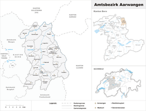
The Aarwangen District was a special area in Switzerland. It was located in the northeast part of the canton of Bern. A canton is like a state or province in other countries. The main town of this district was Aarwangen.
This district no longer exists today. It was officially closed down on December 31, 2009. After that, all its towns became part of a new area. This new area is called the Emmental-Oberaargau administrative region.
Where Was Aarwangen District?
The Aarwangen District was surrounded by several other areas. To the north, it bordered the canton of Solothurn. The canton of Aargau was to its northeast. To the east, it touched the canton of Lucerne.
South of the district was the Trachselwald district. The Burgdorf district was to the southwest. Finally, the Wangen district was to its west.
Towns in the District
The Aarwangen District covered about 154 square kilometers. It included 25 different towns, which are called municipalities. Here are the names of these towns:
- Aarwangen
- Auswil
- Bannwil
- Bleienbach
- Busswil bei Melchnau
- Gondiswil
- Gutenberg
- Kleindietwil
- Langenthal
- Leimiswil
- Lotzwil
- Madiswil
- Melchnau
- Obersteckholz
- Oeschenbach
- Reisiswil
- Roggwil
- Rohrbach
- Rohrbachgraben
- Rütschelen
- Schwarzhäusern
- Thunstetten
- Untersteckholz
- Ursenbach
- Wynau
See also
 In Spanish: Distrito de Aarwangen para niños
 | Dorothy Vaughan |
 | Charles Henry Turner |
 | Hildrus Poindexter |
 | Henry Cecil McBay |

