
Aarwangen facts for kids
Quick facts for kids
Aarwangen
|
||
|---|---|---|

Schloss Aarwangen.
|
||
|
||

Aarwangen
Location in Switzerland

Aarwangen
Location in Canton of Bern
|
||
| Country | Switzerland | |
| Canton | Bern | |
| District | Oberaargau | |
| Area | ||
| • Total | 9.9 km2 (3.8 sq mi) | |
| Elevation | 437 m (1,434 ft) | |
| Population
(Dec 2020 )
|
||
| • Total | 4,638 | |
| • Density | 468.5/km2 (1,213/sq mi) | |
| Postal code |
4912
|
|
| Surrounded by | Bannwil, Graben, Langenthal, Roggwil, Schwarzhäusern, Thunstetten, Wynau | |
| Twin towns | Vodnany (Czech Republic) | |

Aarwangen is a village and a municipality in the Oberaargau administrative district. It is located in the canton of Bern in Switzerland.
Contents
History of Aarwangen

Aarwangen was first mentioned in the year 1255. It was called villa Arwangen back then.
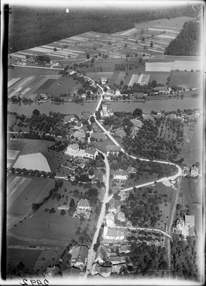
The village grew around a special crossing point over the Aare river. This area had very few places where people could cross the river easily. The first bridge was built in the early 1200s. By the 1500s, it had become a covered wooden bridge. It also served as a customs post, where people paid taxes for goods. A castle protected this important crossing.
In the 1700s, roads became important for trade. In the 1800s, railways also helped. Aarwangen became a busy trade route. Goods moved between the western and eastern parts of Switzerland through here.
The town's coat of arms is black and silver. It comes from the Aarwangen family. They built the first Aarwangen Castle on the riverbank. The castle you see today was built later. It was built by the Landvögte, or Bailiffs, of Bern in the 1500s and 1600s.
The Aarwangen family died out around 1350. The Grünenberg family took over. Both families were loyal to the Habsburg family. The Grünenberg family also disappeared from records by the early 1300s. At that time, the city of Bern took control of the region. In 1432, Bern bought Aarwangen Castle. They later bought the rest of the Grünenberg family's land in 1480. This included the area of today's Aarwangen district.
This is how the Bailiffs of Bern came to Aarwangen. A total of 75 Bailiffs lived in the castle. Their coat of arms, with a black bear, is still on the outer wall. They stayed until 1798, when the Bernese city state ended. The castle was badly damaged during this time. Its inside was almost completely destroyed.
In 1803, the canton of Bern was divided into official districts. Aarwangen became the main town of the district of Aarwangen. The castle was owned by private people for a few years. Then, the Canton of Bern bought it back and fixed it. Today, it is used as a district court and administrative building.
Geography of Aarwangen

Aarwangen covers an area of about 9.90 square kilometers (3.82 square miles). A large part of this land, about 45.6%, is used for farming. Forests cover about 36.2% of the area. Buildings and roads make up about 15.0% of the land. Rivers and lakes cover about 2.9%. Only a small part, 0.3%, is unproductive land.
Most of the built-up area is for homes and buildings (8.8%). Industrial buildings take up 1.4%. Roads and other transport areas make up 3.1%.
The municipality is located on the right bank of the Aare river. Aarwangen is a linear village, meaning it stretches out along a line. It includes areas like Bleuerain, Mumenthal, Schürhof, Vorstadt, Hard, and Moosberg. It also has two small hamlets called Haldimoos and Meiniswil.
Aarwangen's Coat of Arms
The blazon of Aarwangen's coat of arms is described as Per pale Sable and Argent a Bar of the first. This means it has a black and silver design with a black bar.
People and Population (Demographics)
Aarwangen has a population of about 4,600 people. As of 2010, about 12.3% of the people living here were foreign nationals. Over ten years (from 2000 to 2010), the population grew by about 4.7%.
Most people in Aarwangen speak German. This was the first language for about 88.5% of the population in 2000. Albanian was the second most common language, spoken by 3.3% of people. Serbo-Croatian was third, spoken by 3.0%.
In 2008, the population was almost evenly split between males (50.2%) and females (49.8%). About 27.3% of the people living in Aarwangen in 2000 were born there. Many others were born in the same canton (35.9%) or elsewhere in Switzerland (18.4%). About 15.1% were born outside Switzerland.
In 2000, children and teenagers (ages 0–19) made up 26.1% of the population. Adults (ages 20–64) were 61.5%, and seniors (over 64) were 12.4%.
The chart below shows how the population of Aarwangen has changed over time:

Important Heritage Sites
The Speicher (which means Warehouse) and the Tierli house are very important buildings. They are listed as Swiss heritage sites of national significance. The small hamlet of Meiniswil and the area around Aarwangen Castle are also recognized as important Swiss heritage sites.
-
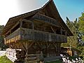
Speicher or Warehouse
-
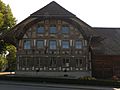
'Tierli house
-
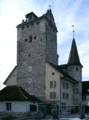
Aarwangen Castle


Economy and Jobs
In 2010, Aarwangen had an unemployment rate of 2.8%. This means a small number of people who wanted jobs couldn't find them.
Many people in Aarwangen work in different areas:
- Primary sector: This includes jobs like farming and forestry. In 2008, about 77 people worked in this area.
- Secondary sector: This includes jobs in manufacturing, mining, and construction. About 467 people worked here. Many of these jobs were in manufacturing (making things).
- Tertiary sector: This includes jobs in services, like sales, transport, hotels, education, and healthcare. About 790 people worked in this sector.
In 2008, there were 1,066 full-time jobs in Aarwangen. Many people who live in Aarwangen travel to other towns for work. Also, people from other towns come to Aarwangen to work.
About 12.3% of working people used public transportation to get to work. Most people, about 59.6%, used a private car.
Religion
Based on the 2000 census, most people in Aarwangen are Christian. About 64.5% belonged to the Swiss Reformed Church. About 13.5% were Roman Catholic. There were also people who belonged to other Christian churches, including Orthodox and Christian Catholic.
Some people followed other religions. About 6.75% of the population was Islamic. There were also a few people who were Jewish, Buddhist, or Hindu. About 5.40% of the population did not belong to any church.
Education in Aarwangen
In Aarwangen, many people have completed higher education. About 40.6% of the population finished non-mandatory upper secondary education. About 10.3% went on to complete even higher education, like at a university.
The school system in the Canton of Bern starts with one year of optional Kindergarten. After that, students go to six years of primary school. Then, they attend three years of lower secondary school. In secondary school, students are grouped by their abilities. After lower secondary school, students can continue their education or start an apprenticeship (learning a trade).
During the 2009-2010 school year, 536 students attended schools in Aarwangen.
- There were 4 kindergarten classes with 100 students.
- There were 15 primary classes with 267 students.
- There were 9 lower secondary classes with 169 students.
Some students in Aarwangen schools were from other countries or spoke a different language at home. This helps make the classrooms diverse.
In 2000, 21 students came to Aarwangen for school from other towns. However, 160 students from Aarwangen went to schools outside the municipality.
Personalities
- Gottfried Egger (1830–1913) was a famous brewer from Aarwangen.
See also
 In Spanish: Aarwangen para niños
