
Madiswil facts for kids
Quick facts for kids
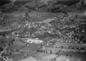
Madiswil
|
||
|---|---|---|
 |
||
|
||

Madiswil
Location in Switzerland

Madiswil
Location in Canton of Bern
|
||
| Country | Switzerland | |
| Canton | Bern | |
| District | Oberaargau | |
| Area | ||
| • Total | 23.17 km2 (8.95 sq mi) | |
| Elevation | 538 m (1,765 ft) | |
| Population
(Dec 2020 )
|
||
| • Total | 3,284 | |
| • Density | 141.74/km2 (367.09/sq mi) | |
| Postal code |
4934
|
|
| Surrounded by | Auswil, Busswil bei Melchnau, Gondiswil, Gutenburg, Kleindietwil, Leimiswil, Lotzwil, Melchnau, Reisiswil, Rütschelen | |

Madiswil is a town, also called a municipality, located in Switzerland. It is part of the Oberaargau administrative district in the canton of Bern. Think of a canton like a state or province.
Over the years, Madiswil has grown by joining with nearby towns. On January 1, 2007, Gutenburg became part of Madiswil. Later, on January 1, 2011, Kleindietwil and Leimiswil also joined the municipality.
Contents
History of Madiswil

Madiswil was first mentioned in old writings in the year 795. Back then, it was called Madalestwilare.
Early Settlements and Land Ownership
The oldest signs of people living in Madiswil are the remains of old forts. These include a ring fort at Weiherköpfli and other forts at Fuchsmatt and Grauenstein. In 795, a person named Heribold gave his land in Madiswil to the church in Rohrbach.
Other religious groups also owned land or had rights in the village. These included the Abbey of St. Gall (in 795), St. Johannsen Abbey (in 1185), and St. Urban's Abbey (in 1194).
Changes in Power
In 1333, the Counts of Kyburg gave away some of their legal rights in Madiswil to the Lords of Grünenberg. However, the Counts of Kyburg kept the more important "high court" rights. By 1406, the Counts of Kyburg were not as rich as before. They gave their high court rights to Bern.
During a conflict called the Old Zürich War, the Lords of Grünenberg supported Frederick III of Habsburg. He was an ally of Zürich against the rest of the Swiss Confederation. In 1443-44, Bern took control of Madiswil. After the war, in 1447, Bern gained some rights over the village. By 1480, Bern bought all remaining rights from the Grünenberg family. Madiswil then became part of the bailiwick of Aarwangen, which was an area governed by Bern.
In the 1500s, Madiswil had arguments with St. Urban's Abbey. They disagreed about who owned and could use some wet meadows near the Langeten river. After the French invasion in 1798, Madiswil became part of the Langenthal District. In 1803, it moved to the Aarwangen District.
The Village Church
The village church, St. Blasius, was first mentioned in 1275. However, it was built on top of even older churches. The oldest church there dates back to the 700s. The church building you see today was built in 1779.
Modern Development
In the 1800s, farms in Madiswil changed. They started raising animals and making dairy products instead of growing grain. A dairy cooperative and three cheese factories opened.
In 1869, the Ammann Mühlebau-Werkstätte started in Madiswil. This was the very first factory of the Ammann company. Today, Ammann is a huge international company with 2,900 employees. It builds equipment for construction. The company's main office is now in nearby Langenthal.
In 1889, a railway station was built in Madiswil. This made it easy for people to travel and work in Langenthal. In the 1960s, new houses were built on the edges of the village. Today, the main part of Madiswil is a center for businesses and industries. It serves the smaller farming communities around it.
A new school building opened in Madiswil in 1984. The older, smaller schools in Wyssbach and Mättenbach were then closed.
Geography of Madiswil
Madiswil covers an area of 23.17 km2 (8.95 sq mi). A large part of this land, about 59.6%, is used for farming. Forests cover about 33.1% of the area.
About 7.0% of the land is settled, meaning it has buildings or roads. A very small part, 0.1%, is rivers or lakes. Another 0.1% is land that cannot be used for farming or building.
Most of the built-up area is for houses and other buildings (4.0%). Roads and other transport areas make up 2.1%. In the forested areas, 31.2% is dense forest. Another 1.8% has orchards or small groups of trees.
For farming, 28.8% of the land is used for growing crops. Pastures for animals make up 28.5%. About 2.3% is used for orchards or grapevines. All the water in Madiswil is from flowing rivers or streams.
The municipality is located in the Langeten valley. It includes the main village of Madiswil. It also includes the smaller communities, called hamlets, of Mättenbach and Wyssbach. As mentioned, the former municipalities of Gutenburg, Kleindietwil, and Leimiswil are now part of Madiswil.
On December 31, 2009, the old district of Amtsbezirk Aarwangen was closed. Madiswil then became part of the Verwaltungskreis Oberaargau on January 1, 2010.
Madiswil's Coat of Arms
The blazon (official description) of Madiswil's coat of arms shows a green background. On it, there is a farmer dressed in silver. He is mowing with a golden sickle that has a silver blade.
People of Madiswil (Demographics)
_395.JPG)

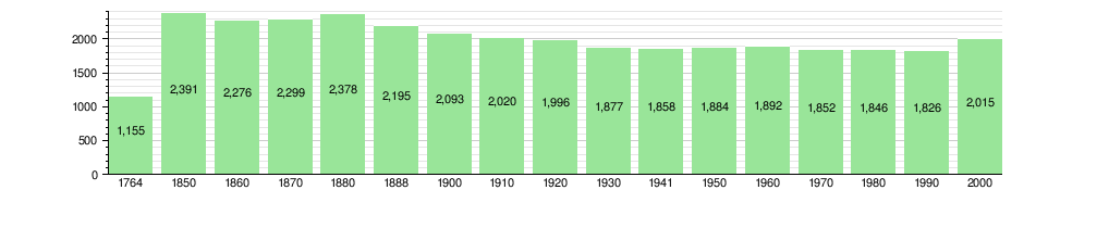
Madiswil has a population of 3,284 people (as of December 2020[update]). As of 2010, about 5.1% of the people living in Madiswil were foreign nationals. Over the last 10 years (from 2000 to 2010), the population changed a little.
Most people in Madiswil (97.1%) speak German as their first language (as of 2000[update]). Albanian is the second most common language (0.6%), followed by Russian (0.2%). A few people also speak French or Italian.
As of 2008, about 49.5% of the population was male and 50.5% was female. Most residents were Swiss citizens. About 37.5% of the people living in Madiswil in 2000 were born there. Another 38.2% were born in the same canton (Bern).
In 2010, children and teenagers (ages 0–19) made up 21.9% of the population. Adults (ages 20–64) made up 59.5%, and seniors (over 64) made up 18.5%.
In 2000, there were 831 single people in Madiswil who had never been married. There were 1,012 married people, 113 widows or widowers, and 59 divorced people.
There were 233 households with only one person in 2000. Also, 64 households had five or more people. Most apartments (91.5%) were lived in all the time. A small number (5.7%) were used only at certain times of the year, and 2.8% were empty. In 2011, the number of empty homes was very low, at 0.54%.
The chart below shows how the population has changed over time:
Economy of Madiswil
In 2011, Madiswil had a low unemployment rate of 1.15%. This means most people who wanted to work had jobs. As of 2008, there were 1,250 people working in the municipality.
Economic Sectors
Jobs are often grouped into three main types:
- Primary sector: This includes jobs that get raw materials from nature. In Madiswil, 299 people worked in this sector, mostly in farming. There were 112 businesses in this area.
- Secondary sector: This includes jobs that make things. There were 337 people working in this sector, with 50 businesses. Most of these jobs (63.7%) were in manufacturing, like factories. The rest (36.3%) were in construction.
- Tertiary sector: This includes jobs that provide services. There were 614 people working in this sector, with 89 businesses. These jobs included sales, transportation, hotels, restaurants, healthcare, and education. For example, 40.2% of these jobs were in healthcare.
Commuting to Work
In 2000, 332 workers traveled into Madiswil for their jobs. However, 650 workers traveled out of Madiswil to work in other places. This means more people leave Madiswil for work than come into it.
About 10.5% of working people used public transportation to get to work. A much larger number, 54.8%, used a private car.
Religion in Madiswil

Based on the 2000 census, most people in Madiswil belonged to Christian churches. About 79.7% were part of the Swiss Reformed Church. Another 6.4% were Roman Catholic.
A smaller number of people belonged to other Christian churches (9.23%). There were also some people who followed Islam (1.04%), Buddhist (4 people), and Hindu (4 people) faiths. About 4.37% of the population did not belong to any church or did not answer the question.
Weather in Madiswil
Madiswil has about 134.7 days of rain or snow each year. On average, it gets about 1,150 mm (45 in) of precipitation (rain or snow).
The wettest month is June, with an average of 128 mm (5.0 in) of rain or snow. It rains or snows for about 12.6 days in June. May has the most days with precipitation (13.3 days), but less total rain or snow (106 mm (4.2 in)). The driest month is October, with about 76 mm (3.0 in) of precipitation over 8.3 days.
Education in Madiswil
In Madiswil, about 40.9% of the population has completed high school (non-mandatory upper secondary education). About 11.3% have gone on to higher education, like a university or a specialized college (Fachhochschule).
School System
The school system in the Canton of Bern works like this:
- One year of optional Kindergarten.
- Six years of Primary school.
- Three years of required lower Secondary school. In this stage, students are grouped based on their abilities.
- After lower Secondary, students can choose to continue schooling or start an apprenticeship (on-the-job training).
During the 2009-10 school year, 243 students attended classes in Madiswil. There were 2 kindergarten classes with 48 students. In primary school, there were 8 classes with 159 students. In lower secondary, there were 2 classes with 36 students.
In 2000, 2 students came to Madiswil schools from other towns. However, 72 students from Madiswil went to schools outside the municipality.
Library
Madiswil has a public library called the Schul- und Gemeindebibliothek Madiswil. In 2008, the library had 4,000 books and other media. It loaned out 12,000 items that year. The library was open for 128 days, averaging 4 hours per week.
See also
 In Spanish: Madiswil para niños
