
Rohrbach, Switzerland facts for kids
Quick facts for kids
Rohrbach
|
||
|---|---|---|
_244.JPG) |
||
|
||

Rohrbach
Location in Switzerland

Rohrbach
Location in Canton of Bern
|
||
| Country | Switzerland | |
| Canton | Bern | |
| District | Oberaargau | |
| Area | ||
| • Total | 4.08 km2 (1.58 sq mi) | |
| Elevation | 584 m (1,916 ft) | |
| Population
(Dec 2020 )
|
||
| • Total | 1,520 | |
| • Density | 372.5/km2 (965/sq mi) | |
| Postal code |
4938
|
|
| Surrounded by | Auswil, Huttwil, Kleindietwil, Rohrbachgraben | |

Rohrbach is a small town, also called a municipality, in the Oberaargau region of the canton of Bern in Switzerland. It's a place with a long history and a mix of farming and industry.
Contents
History of Rohrbach
Rohrbach was first mentioned in old records way back in 795. At that time, a local noble named Heribold gave some of his land to the church in Rohrbach.
Early Ownership and Power
In the 800s, the Abbey of St. Gall received land around Rohrbach. An "administrator" was set up in Rohrbach to manage the Abbey's lands. This meant the people living on these lands were protected by the Abbey's laws, not the local count's.
Later, in the 1300s, the power over Rohrbach changed hands many times. It was controlled by different noble families, like the Barons of Ruti, the Count of Signau, and the Count of Grünenberg. These families had the right to make local laws and hold courts.
Becoming Part of Bern
Eventually, a man named Hermann of Eptingen gained control of Rohrbach. He supported the Habsburgs during a conflict called the Old Zürich War (1440–46). Because of this, a Bernese army took over the village. After the war, Rohrbach was given back to Hermann's wife in 1449.
However, in 1504, the city of Bern bought the entire village from Hermann's family. By 1505, Rohrbach became part of Bern's territory, specifically the bailiwick (an area managed by a local official) of Wangen. Even so, Rohrbach kept some special rights. For example, its people didn't have to do forced labor for the local official, and in wars, they marched under Bern's own flag.
After the French invasion in 1798, Switzerland's government changed. Rohrbach became part of the District of Langenthal and later the District of Aarwangen in 1803.
St. Martin's Church
The village church, called St. Martin's Church, is very old. It was first mentioned in 795, the same year Rohrbach appeared in records. The church building you see today was built in 1738.
Originally, the church belonged to the Abbey of St. Gall. But in 1345, it was sold to the Knights Hospitaller, a group of knights who cared for the sick. When the Protestant Reformation happened in 1528, Bern took over the church's properties, including St. Martin's.
Growth and Industry
Starting in the 1700s, many people in Rohrbach began weaving at home to earn extra money, in addition to farming. This was called "cottage industry."
A big change came in 1889 when the Langenthal-Huttwil-Wolhusen railroad opened a station in Rohrbach. This helped the village grow and brought more factories and businesses. Today, more than half of the jobs in Rohrbach are in manufacturing. Many people also travel to nearby Langenthal for work. Around 1980, a new neighborhood called Riedmatt was built to provide homes for the growing population.
Geography and Landscape
_246.JPG)
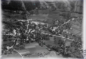
Rohrbach covers an area of about 4.1 square kilometers (1.6 square miles). A large part of this land, about 62.8%, is used for farming. Forests cover about 20% of the area.
About 15.9% of Rohrbach is covered by buildings and roads. A very small amount, 0.2%, is made up of rivers or lakes.
Land Use Details
- Built-up areas: Industrial buildings make up 3.4% of the total area, while homes and other buildings are 9.8%. Roads and transportation take up 1.7%.
- Forests: Most of the forested land (18.1% of the total area) is dense forest. Another 2.0% has orchards or small groups of trees.
- Farmland: About 37.2% of the agricultural land is used for growing crops. Pastures for animals make up 23.7%, and 2.0% is used for orchards or vineyards.
All the water in Rohrbach is from flowing rivers or streams.
Village Structure
The municipality of Rohrbach includes the main village of Rohrbach itself. It also has several smaller settlements called hamlets, such as Boden, Brand, Kasern, and Sossau, along with scattered farmhouses.
On January 1, 2010, Rohrbach became part of the newly created Verwaltungskreis Oberaargau, which is a larger administrative district.
Coat of Arms
The blazon (official description) of Rohrbach's coat of arms is: Gules a Mullet Or on a Mount of Six Coupeaux Vert. This means it shows a gold star on a green hill with six peaks, all on a red background.
Population and People
_269.JPG)
_248.JPG)
Rohrbach has a population of about 1,461 people (as of 2010). Over the last ten years (2000-2010), the population has grown slightly by 1.2%. More people moved into Rohrbach than left, which helped the population grow.
Languages Spoken
Most people in Rohrbach (about 96.1%) speak German as their main language. Other languages spoken include Albanian (0.8%) and Serbo-Croatian (0.7%).
Population Makeup
As of 2008, the population was almost evenly split between males (48.7%) and females (51.3%). Most residents are Swiss citizens. About 38.8% of the people living in Rohrbach in 2000 were born there. Another 40.5% were born in the same canton (Bern).
Age Groups
In 2010, children and teenagers (0–19 years old) made up 21.5% of the population. Adults (20–64 years old) were the largest group at 59.4%, and seniors (over 64 years old) made up 19.1%.
Housing
In 2000, most apartments in Rohrbach (91.6%) were lived in all the time. Only a small number were empty or used only part of the year.
Population Changes Over Time
The chart below shows how Rohrbach's population has changed over many years:

Important Sites
The entire village of Rohrbach is recognized as an important Swiss Heritage Site. This means its buildings and layout are historically valuable and protected.
Economy and Jobs
_256.JPG)
In 2011, Rohrbach had a low unemployment rate of 1.63%. This means most people who wanted jobs had them.
Types of Jobs
As of 2008, there were 527 people working in Rohrbach. These jobs were divided into three main types:
- Primary sector: 41 people worked in this sector, mainly in farming. There were about 20 businesses related to farming.
- Secondary sector: 314 people worked here, mostly in manufacturing (making things) and construction (building things). There were 21 businesses in this sector.
- Tertiary sector: 172 people worked in this sector, which includes services. There were 44 businesses here.
Many jobs in the tertiary sector involved sales, transportation, hotels, restaurants, and healthcare.
Commuting
In 2000, 287 workers traveled into Rohrbach for their jobs, while 482 workers traveled out of Rohrbach to work elsewhere. This means more people leave Rohrbach for work than come in. Most people (60.5%) used a private car to get to work, while 11.6% used public transportation.
Religion in Rohrbach
_253.JPG)
According to the 2000 census, most people in Rohrbach (83.4%) belonged to the Swiss Reformed Church, which is a Protestant church. About 6.2% were Roman Catholic. A smaller number of people belonged to other Christian churches (4.47%), or were Islamic (0.95%) or Hindu (0.95%). About 3.74% of the population did not belong to any church.
Education and Schools
In Rohrbach, about 41.9% of the population has finished upper secondary education (like high school). About 8.4% have gone on to higher education, such as university.
School System in Bern
The Canton of Bern has a specific school system:
- One year of non-mandatory Kindergarten.
- Six years of Primary school.
- Three years of obligatory lower Secondary school, where students are grouped by their abilities.
- After lower Secondary, students can continue their education or start an apprenticeship (learning a trade on the job).
Students in Rohrbach
During the 2009–10 school year, 161 students attended classes in Rohrbach.
- There were 2 kindergarten classes with 29 students.
- There were 6 primary classes with 106 students.
- There was one lower secondary class with 26 students.
Some students in Rohrbach's schools were not Swiss citizens, and some spoke a different first language than the classroom language. In 2000, 13 students came to Rohrbach's schools from other towns, while 100 students from Rohrbach went to schools outside the municipality.
See also
 In Spanish: Rohrbach para niños
