Addingrove facts for kids
Quick facts for kids Addingrove |
|
|---|---|
 Addingrove Farm |
|
| OS grid reference | SP666110 |
| Civil parish |
|
| Unitary authority |
|
| Ceremonial county | |
| Region | |
| Country | England |
| Sovereign state | United Kingdom |
| Post town | Aylesbury |
| Postcode district | HP18 |
| Dialling code | 01844 |
| Police | Thames Valley |
| Fire | Buckinghamshire |
| Ambulance | South Central |
| EU Parliament | South East England |
| UK Parliament |
|
| Website | Oakley Parish Council |
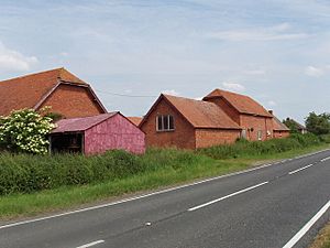
Addingrove is a place in Buckinghamshire, England. It used to be a small village or hamlet. Today, it's mostly empty, with just Addingrove Farm and one cottage left. It's about 4 miles (6.4 km) northwest of Thame, a market town in Oxfordshire. You can find Addingrove on the B4011 road, between Oakley and Long Crendon. It's part of the civil parish of Oakley.
What's in a Name?
The name Addingrove comes from an old language called Old English. It means "Æddi's wood." Over many years, from the 1000s to the 1400s, the name changed. It went from Eddingrave to Adegrave and Adingrave before becoming Addingrove, which is what we call it today.
Who Owned Addingrove?
In 1086, a very important book called the Domesday Book was made. It recorded that a man named Ulward owned the land of Eddingrave (Addingrove) before the Norman conquest of England. After the Normans took over, the land was given to a powerful Norman lord, Walter Giffard.
Addingrove stayed with Walter Giffard's family for a long time. Later, in 1256, it passed to Joan Marshal, who was a descendant of Giffard. She married William de Valence, 1st Earl of Pembroke. After William's grandson, Aymer de Valence, died in 1324, Addingrove went to Elizabeth de Comyn. She later married Richard Talbot, 2nd Baron Talbot.
The ownership of Addingrove often changed hands through marriages or inheritances. It was sometimes linked with other nearby lands, like Pollicott and Boarstall. Over the centuries, different important families owned or rented the land, including the Morel family, the Crokes, and the Dormers. By the 1700s, it was owned by Sir John Aubrey, 6th Baronet, which again linked it to the manor of Boarstall.
After Addingrove became mostly empty, its land was divided up. It was shared among the nearby villages of Oakley, Brill, and Chilton.
The Old Chapel
Around 1142, a powerful lady named the Empress Maud gave the church in Oakley and its smaller chapels to a group of monks called the Augustinians. Addingrove had one of these smaller chapels. It was still there in 1318. But by the late 1700s, the chapel had fallen into ruins and was no longer used.
Where Was the Village?
The place where the old village of Addingrove and its chapel might have been is about 0.25 miles (400 meters) north of Addingrove Farm. Today, the only building left there is an old, broken-down barn. However, old maps from the late 1800s show this was the spot of the original Addingrove Farm.
If you look closely, you might see some clues about the old village. There are slight dips in the ground that suggest where houses once stood. A small raised path might show where an old track used to be. Also, in the fields nearby, you can see "ridge and furrow" patterns. These are wavy lines in the ground that show where people used to farm in medieval times. They can help us guess where the old village ended.
About 0.25 miles (400 meters) east of Addingrove Farm, the B4011 road crosses a small stream. Next to the stream, there's a straight, rectangular ditch from the medieval period. This ditch was about 23 feet (7 meters) wide and was fed by the stream. It might have been a moat around a manor house, but there's no sign of a house ever being there. So, it might have been a large pond used for keeping fish.
See Also
 | Emma Amos |
 | Edward Mitchell Bannister |
 | Larry D. Alexander |
 | Ernie Barnes |


