Alay Range facts for kids
Quick facts for kids Alay Range |
|
|---|---|

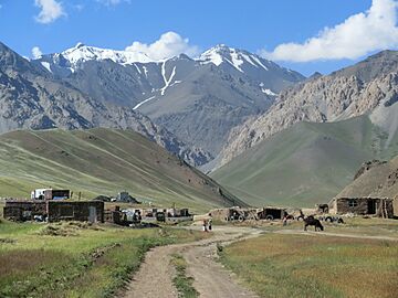
Alai Range from Jiptik Valley
|
|
| Highest point | |
| Elevation | 5,544 m (18,189 ft) |
| Dimensions | |
| Length | 350 km (220 mi) W-S |
| Width | 20 km (12 mi) N-S |
| Geography | |
| Country | |
| Range coordinates | 39°40′N 72°0′E / 39.667°N 72.000°E |
The Alay Range is a long chain of mountains in Central Asia. It stretches from the Tien Shan mountains in Kyrgyzstan all the way west into Tajikistan. These mountains are part of a bigger group called the Pamir-Alay mountain system.
The Alay Range runs mostly from east to west. Its tallest peak is Pik Tandykul, which stands at an impressive 5,544 meters (about 18,189 feet) high! This mountain range forms the southern edge of the Fergana Valley, a large and fertile area. To its south, the mountains drop steeply down into the Alay Valley. Another well-known peak in the range is Pik Skobeleva, reaching 5,051 meters.
Water from the southern slopes of the Alay Range flows into the Kyzylsuu River, which is also known as the Vakhsh River. This river eventually joins the mighty Amu Darya. On the northern side, streams flow into the Syr Darya river system. These northern streams empty into the Fergana Valley.
Traveling through these mountains is possible thanks to special routes called passes. The European route E007, which connects cities like Tashkent, Osh, and Irkeshtam, crosses the Alay Range through the Taldyk Pass. The famous Pamir Highway also travels through parts of this range, connecting different regions.
Contents
Discovering the Alay Mountains
The Alay Mountains are an important part of the larger mountain systems in Central Asia. They are located just north of the Alay Valley. To the south of that valley, you would find other ranges like the Trans-Alay Range and parts of the Pamir Mountains. The term Pamir-Alay is used for many of these mountain systems together, but it does not include the Pamir Mountains themselves.
How the Alay Mountains Were Formed
The Alay Range was created by powerful movements of the Earth's crust. Scientists call this process a "horst-anticline formation." It happened during an ancient mountain-building event known as the Hercynian orogeny. This means that huge forces pushed and folded the Earth's layers upwards to create these mountains.
In some parts of the range, there are long cracks in the Earth's crust called tectonic faults. These faults run parallel to the mountains in the western and central areas. In the eastern part, they are oriented differently, running from south to north.
The rocks that make up the Alay Range are very old and varied:
- In the western and central sections, you can find rocks from the Silurian, Devonian, and Carboniferous periods. These periods were hundreds of millions of years ago! These rocks include sandstone, limestone, dolomite, and different types of schist. They can be very thick, sometimes up to 3,000 meters.
- The eastern section has rocks from the Jurassic period, which is also very ancient. These layers, up to 3,300 meters thick, are made of rocks like conglomerates (rocks made of smaller pieces cemented together) and argillites.
In certain places, like the Kichi-Alay and Kaiyndy Mountains, you can see other types of rocks mixed in. These include granite and syenite, which formed from molten rock deep inside the Earth.
The lower hills and valley floors around the Alay Range are covered with more recent sedimentary rocks. These layers, up to 200 meters thick, include clay, sand, and gravel. Some of these deposits were left behind by ancient glaciers.
Valuable Resources in the Mountains
The Alay Range is rich in natural resources. It holds deposits of many important minerals. These include iron, bauxite (used to make aluminum), and coal. Other minerals found here are mercury, antimony, tungsten, and bismuth. Some of these minerals are very important for different industries.
See also
- Mount Imeon
- Trans-Alay Range
 | Madam C. J. Walker |
 | Janet Emerson Bashen |
 | Annie Turnbo Malone |
 | Maggie L. Walker |


