Amounderness Hundred facts for kids
| Hundred of Amounderness | |
 |
|
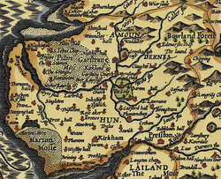
 Amounderness Hundred depicted in John Speed's 1610 map of Lancashire |
|
| Geography | |
| History | |
| Created | In antiquity |
Quick facts for kids Subdivisions |
|
|---|---|
| Type | Parish(es) |
| Units | Preston • Kirkham • Lytham • Poulton-Le-Fylde • Bispham • St Michael-On-Wyre • Garstang |
The Amounderness Hundred is a historic area in Lancashire, North West England. It is one of the six main parts of the historic county. The name "Amounderness" is very old, even older than the system of "hundreds" that became common in the 1200s. It might have originally been a Norse wapentake, which was a similar type of local division.
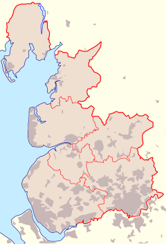
In the Domesday Book of 1086, Amounderness referred to lands north of the River Ribble. This included some parts of Yorkshire at the time. Eventually, this area became part of Lancashire. Geographically, it sits between the Lune and the Ribble. It stretches along the coast from the Irish Sea to the Forest of Bowland.
Contents
What's in a Name?
People in the 1800s thought the name "Amounderness" first appeared in 705. They spelled it Hacmunderness. Later, in the 1086 Domesday Book, it was written as Agemundrenessa.
There are two main ideas about where the name comes from.
- One older idea from the 1800s suggested it meant "a promontory sheltered by oaks." This idea came from combining old words for "oak" and "protection."
- The more accepted idea today is that the area is named after a Norse warlord named Agmundr. He was a powerful leader who died in a battle in 910. It was common for "hundreds" to be named after a meeting place or an important person. The "-ness" part of the name means "promontory" or "headland," suggesting a coastal meeting spot.
The name "Agmundr" comes from Old Norse words meaning "awe" or "terror" and "protection." This name also appeared in Old Swedish and Old West Norse.
Some old writings from the 7th century were once thought to mention Amounderness. However, these writings only refer to lands "next to the Ribble." They do not specifically name Amounderness. It seems a historian in the 1500s might have made a mistake.
How Amounderness Became Part of England
In 934, Amounderness was given to Wulfstan I, who was the Archbishop of York. This gift came from Athelstan, who was the King of England. It was once thought that the king won this land in a battle. But actually, King Athelstan had bought the land in 926.
According to the old records, Amounderness was much larger back then. It stretched from the sea along the Cocker to its source. Then it went to a spring called Dunshop, down to the River Hodder, and along the River Ribble to the Irish Sea. This description shows it was a very large area.
Today, the eastern edge of Amounderness is described as being near the fells (hills) on the Yorkshire border. This places it within the modern Forest of Bowland. After the Norman conquest of England, this eastern part became known as the Lordship of Bowland.
In the 900s, Amounderness was very important for travel and trade between Dublin and York. It was a key location. By the 1100s, Amounderness and Bowland became two separate areas, each with its own royal forest.
Where is Amounderness Today?
The historic area of Amounderness roughly matches some of today's administrative districts. These include the Fylde, Wyre, Preston, and part of Ribble Valley. This part of Ribble Valley is north of the River Ribble and within the historic boundaries of Lancashire.
Many towns and villages were part of Amounderness, such as:
- Bispham, Blackpool
- Broughton-in-Amounderness
- Chipping
- Cockerham
- Garstang
- Kirkham
- Knott End-on-Sea
- Mitton
- Pilling
- Preesall
- Poulton-le-Fylde
- Preston
- Ribchester
The name "Amounderness" is still used today for a road called Amounderness Way. This road is part of the A585 road. It runs between Mains Lane in Thornton and Dock Street in Fleetwood.
Amounderness Registration District
Amounderness was also the name of a "registration district." This was an area where births, deaths, and marriages were officially recorded. This district existed from April 1, 1935, to March 31, 1974. Before 1935, these records were handled by the Preston Registration District.
The Amounderness registration district included:
- Preston Rural District
- Fulwood Urban District
- Longridge Urban District
This area was much smaller than the historic hundred. It even included some areas south of the Ribble that were not part of the original hundred.
It included many civil parishes (local administrative areas) like:
- Barton
- Broughton
- Cuerdale
- Farington
- Fulwood
- Goosnargh
- Grimsargh
- Haighton
- Hutton
- Lea
- Little Hoole
- Longton
- Much Hoole
- Penwortham
- Samlesbury
- Walton-le-Dale
- Whittingham
- Woodplumpton
In 1974, most of these parishes moved to the Preston and South Ribble registration district. Other parishes like Alston, Dilworth, Dutton, Hothersall, and Ribchester moved to the Ribble Valley registration district.
See Also
- Hundreds of Lancashire


