Arana Hills, Queensland facts for kids
Quick facts for kids Arana HillsMoreton Bay, Queensland |
|||||||||||||||
|---|---|---|---|---|---|---|---|---|---|---|---|---|---|---|---|

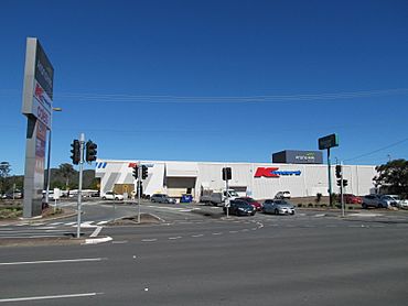
Arana Hills Plaza, 2013
|
|||||||||||||||
| Population | 6,971 (2021 census) | ||||||||||||||
| • Density | 1,884/km2 (4,880/sq mi) | ||||||||||||||
| Postcode(s) | 4054 | ||||||||||||||
| Area | 3.7 km2 (1.4 sq mi) | ||||||||||||||
| Time zone | AEST (UTC+10:00) | ||||||||||||||
| Location |
|
||||||||||||||
| LGA(s) | City of Moreton Bay | ||||||||||||||
| State electorate(s) | Ferny Grove | ||||||||||||||
| Federal Division(s) | Dickson | ||||||||||||||
|
|||||||||||||||
Arana Hills is a friendly suburb located in the City of Moreton Bay, Queensland, Australia. It's part of Division 10 in the city. In 2021, about 6,971 people called Arana Hills home.
Contents
Discovering Arana Hills' Location
Arana Hills is about 12 kilometers (7.5 miles) north-west of Brisbane, which is the capital city of Queensland. It's right next to the beautiful Bunyaville Forest Reserve. Many people also know this area as part of the "Hills District."
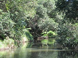
Even though the Kedron Brook waterway doesn't flow directly through Arana Hills, the suburb is located in the northern part of its wider catchment area.
A Look Back: Arana Hills' History
For a long time, until the 1950s, the area around Arana Hills was mostly forests and small farms. The very first land here was bought in 1878 by Frederick and Elizabeth Patrick. But the suburb we see today didn't really start to form until 1937, when the land was divided into smaller blocks.
How Arana Hills Got Its Name
In 1956, the first modern housing development in the Shire of Pine Rivers began in Arana Hills. It was called Camden Park. Many people bought land there because it was affordable.
However, there were other places named Camden Park, which caused confusion. So, in March 1962, people held a meeting to choose a new name. In June 1962, the Camden Park Progress Association suggested "Arana Hills." They thought "Arana" was an Aboriginal word meaning "welcome." The name was officially approved in December 1962. Later, it was discovered that "Arana" actually means "moon" in an Aboriginal language.
Changes Over Time
Arana Hills used to be part of the Pine Rivers shire. But in 2008, it joined with other local councils to create the Moreton Bay Region, which is now known as the City of Moreton Bay.
In 2008, Arana Hills was hit by some very strong thunderstorms. These storms caused a lot of damage to homes and properties. Many volunteers and emergency crews worked hard to clean everything up. The area has since recovered, though some trees were lost.
Who Lives in Arana Hills?
Let's look at the people who live in Arana Hills.
- In 2011, there were 6,313 people. Slightly more than half (51%) were female, and 49% were male.
- The average age was 35 years old, which is a bit younger than the national average of 37.
- Most people (82.5%) were born in Australia. Other common birthplaces included England (3.5%), New Zealand (3.3%), and South Africa (0.9%).
- Most people (92.7%) spoke only English at home. Other languages spoken included Hindi, Cantonese, and Italian.
The population has grown over the years:
- In 2016, Arana Hills had 6,810 people.
- By 2021, the population grew to 6,971 people.
Learning in Arana Hills
Arana Hills has a private school called Pine Community School.
- Pine Community School is for primary students (Prep to Year 6).
- It's located at 123 Bunya Road.
- In 2018, the school had 94 students and 11 teachers.
There are no government schools directly in Arana Hills. Students usually go to nearby schools like:
- Grovely State School in Keperra (for primary).
- Ferny Hills State School in Ferny Hills (for primary).
- Patricks Road State School also in Ferny Hills (for primary).
- Mitchelton State High School in Mitchelton (for secondary).
- Ferny Grove State High School in Ferny Grove (for secondary).
Things to Do and See
Arana Hills has several places for shopping and community activities.
Shopping and Services
You'll find a few local shopping areas in Arana Hills. There's also a larger indoor shopping center. This center opened in 1978 and has big stores like Kmart and Coles supermarket.
The Moreton Bay City Council runs a Public Library in Arana Hills. It's located at 63 Cobbity Crescent and opened in 1976.
Churches
- Arana Hills Uniting Church (also called The Hills Uniting Church) is at 14 Alstonia Street.
- The Anglican Church for the Grovely Parish is All Saints Church, found in Cobbity Crescent.
Parks and Green Spaces
Arana Hills has many parks where you can play and relax:
- Bandicoot Gully
- Bob O'Neil Park
- Brian Battersby Reserve
- Camden Park
- John Carter Park
- Leslie Patrick Park
- Sue Miller Park
- Wightman Reserve
- William Scott Park
 | Kyle Baker |
 | Joseph Yoakum |
 | Laura Wheeler Waring |
 | Henry Ossawa Tanner |


