
Bunya, Queensland facts for kids
Quick facts for kids BunyaQueensland |
|||||||||||||||
|---|---|---|---|---|---|---|---|---|---|---|---|---|---|---|---|

Bunyaville Environmental Education Centre
|
|||||||||||||||

Bunya
Location in Queensland
|
|||||||||||||||
| Population | 1,968 (2021 census) | ||||||||||||||
| • Density | 135.7/km2 (351/sq mi) | ||||||||||||||
| Postcode(s) | 4055 | ||||||||||||||
| Area | 14.5 km2 (5.6 sq mi) | ||||||||||||||
| Time zone | AEST (UTC+10:00) | ||||||||||||||
| Location |
|
||||||||||||||
| LGA(s) | City of Moreton Bay | ||||||||||||||
| State electorate(s) | Ferny Grove | ||||||||||||||
| Federal Division(s) | Dickson | ||||||||||||||
|
|||||||||||||||
Bunya is a suburb located in the City of Moreton Bay in Queensland, Australia. In 2021, about 1,968 people lived here. It is found north-west of Brisbane, which is the capital city of Queensland.
Contents
Exploring Bunya's Nature and Rivers
Bunya is known for its natural beauty. The suburb's northern edge is bordered by the South Pine River.
Bunya Crossing: A River Ford
A special spot called Bunya Crossing is a shallow place where you can cross the South Pine River. It's at the end of Dugandan Road and doesn't have a bridge. It's a unique natural crossing point.
Bunyaville Conservation Park: A Green Escape
A big part of Bunya is the Bunyaville Conservation Park. This park is looked after by the Queensland Parks and Wildlife Service. It's home to many types of trees like spotted gum, grey ironbark, and forest red gum. The park also protects a rare type of spotted gum tree found only in the Brisbane area. It's a great place to explore nature!
Bunya's Past: How It Got Its Name
The name Bunya comes from the Kabi language, an Aboriginal language. The word bonyi or bunyi means the Bunya pine tree (Araucaria bidwillii). These trees are very important to the local Indigenous people.
Early Schools in Bunya
Bunya used to have its own school, Bunya State School. It opened in 1875 but closed many years later in 1965.
Who Lives in Bunya?
In 2021, Bunya had a population of 1,968 people. Let's look at some past numbers too:
- In 2011, there were 1,787 people living in Bunya.
- By 2016, the population grew to 1,916 people.
Most people living in Bunya were born in Australia. Other countries of birth included England, New Zealand, and South Africa. Most people speak English at home.
Learning and Education in Bunya
While Bunya doesn't have regular schools, it has a special place for learning about nature.
Bunyaville Environmental Education Centre
The Bunyaville Environmental Education Centre is located on Old Northern Road. It's a fantastic outdoor center where students can learn about the environment and nature. It's a great resource for schools in the area.
Nearby Schools
For everyday schooling, students in Bunya usually go to nearby suburbs. Primary schools like Patrick Road State School in Ferny Hills and Samford State School in Samford Village are close by. For high school, Ferny Grove State High School in Ferny Grove is the nearest government option.
Places and Services in Bunya
Bunya has some important facilities and many parks for everyone to enjoy.
Bunya Cemetery
Bunya Cemetery is a historic site. It's a closed cemetery, meaning no new burials happen there. There is only one headstone left from 1892, which belongs to Thomas Broad.
Emergency Services
The Arana Hills SES Facility is located in the James Drysdale Recreation Reserve. The SES helps people during emergencies like floods or storms.
Parks and Recreation
Bunya has several parks and reserves where you can play sports or just relax outdoors:
- Bunya Crossing
- George Biggs Playground
- Hill View Park
- James Drysdale Recreation Reserve
- Surrey Farm Park
- Ted Corbould Reserve
James Drysdale Recreation Reserve is a popular spot for sports. It's home to the Pine Hills Pythons football (soccer) club and the Pine Hills Netball Club.
Images for kids
-
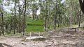
Bunya Cemetery, 2015
-
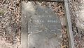
Only surviving headstone, Bunya cemetery, 2015 - "Thomas Broad, died Apr 2nd 1892 aged 49 years"


