
Archdeacon Newton facts for kids
Quick facts for kids Archdeacon Newton |
|
|---|---|
 Garthorne Farm at Archdeacon Newton |
|

Archdeacon Newton
|
|
| OS grid reference | NZ255175 |
| Unitary authority |
|
| Ceremonial county | |
| Region | |
| Country | England |
| Sovereign state | United Kingdom |
| Post town | DARLINGTON |
| Postcode district | DL2 |
| Dialling code | 01325 |
| Police | Durham |
| Fire | County Durham and Darlington |
| Ambulance | North East |
| EU Parliament | North East England |
| UK Parliament |
|
Archdeacon Newton is a tiny place in England. It's a hamlet, which means it's a very small village. It's also a rural parish with several farms. You can find it in the area of Darlington, in County Durham.
This area is special because it has an abandoned village site. This old village is now mostly fields and farm buildings. It's located just a short distance north-west of Darlington. The lost village was around in the early 1400s. People lived there until at least the 1890s.
At the south end of the old village site, there was a moated manor house. A moat is a deep, wide ditch, usually filled with water, surrounding a castle or house. Part of this old house is still there as the Old Hall, which is now a barn. At the north end of the site, there was a chapel. In the middle, there were old house plots and fields. The site of this abandoned village is now a scheduled monument. This means it's a very important historical site protected by law. The Old Hall is also a listed building, meaning it's a building of special historical interest.
Contents
What is the History of Archdeacon Newton?
Archdeacon Newton was once part of the larger Darlington parish. The name "Archdeacon Newton" comes from the Middle Ages. It's believed that the Archdeacon of Durham founded and built the village that is now abandoned. Another idea is that the land was rented from the archdeacon.
Around the year 1800, a famous bull called the "Durham Ox" was bred here. Its breeder was Hilton "High Price" Middleton. A pub in Cockerton Green was even named after this famous ox!
In 1894, the Church Commissioners owned the land. The population was 52 people then. This was less than its highest number of 72 people in 1801. Back then, people from Archdeacon Newton had special seats at St Cuthbert's church in Darlington. Methodist prayers were also held in a farmhouse kitchen. This was before Holy Trinity Church was built closer by in 1836.
What Archaeological Sites and Finds Are There?
The old manor house of the village still exists at Hall Farm. It's now a farm building but still has some parts from the medieval period. Another farm building nearby might have been an early 1500s house.
Besides these buildings, the abandoned village is marked by earthworks. These are changes in the shape of the land made by people long ago. They show where the medieval moated site and old fields were. There are also signs of three fish ponds. One is still a duck pond today. It was once thought there was only one fish pond. So far, no very old prehistoric or Roman remains have been found here. This is because no big digs have happened as of 2010.
What Was the Abandoned Settlement Like?
The area east of the Archdeacon Newton road is where the medieval abandoned village was. This whole area is a scheduled monument. The manor house was at the south end of the settlement. The village had three farms and a row of small houses. You can still see where these houses were as house platforms in the fields.
It's now thought that these buildings were tenant tofts. A toft is a piece of land where a house once stood. They were connected to the manor house. Cobbled banks and ditches running east to west show where the original enclosures of these tofts were. These banks are about 4 meters wide and 0.6 meters high. The ditches are about 3 meters wide and 0.3 meters deep.
There's also a ridge and furrow field nearby. This is a pattern of ridges and dips in a field from old farming methods. A trackway, about 4 meters wide, runs from the east side of the site. It goes south-east for about 240 meters to a modern fence.
What is the Old Hall and Moated Site?

The Old Hall is one of the farm buildings at Hall Farm. It's a surviving medieval house or manor house. It probably dates back to the 1300s. It was changed in the 1500s and 1600s. In the early 2000s, it was damaged by fire and then got a new roof. It's a two-story listed building that became a barn in the 1800s. It has a Welsh slate roof.
The Old Hall is built with stone. It includes medieval and Tudor carved stone. You can see parts like mullions (vertical bars in a window) and fireplaces. Old Buttresses (supports), broken arches, and fireplaces from the manor house are still standing. They are part of the Old Hall building. It measures about 18 meters by 9 meters. It has two Tudor fireplaces. There are also remains of archways on the outside walls at each end.
The moated manor house was at the south end of the abandoned village site. This is where the farm buildings are now. In the 1500s and 1600s, the manor had many rooms. These included a hall, a parlor, a new chamber, a little chamber, a "lofte beneath the doors," a buttery (a room for storing drinks), a kitchen, and a stable. Dips in the ground at the south end of the site show where the original moat was.
Was There a Chapel?
People think the chapel was on a 2-meter high triangular platform. This platform is at the north end of the site, on the south side of Newton Lane. There's a ditch along the south side of this platform. We know there was a chapel because of a special permission given in 1414. It allowed Robert Fisher, John Nicholson, and John Deves to hold religious services in a chapel at Archdeacon Newton.
What About Other Enclosures?
Another enclosure has been found by aerial photography. This is about 0.5 kilometers north-west of the hamlet. It's on the south side of Newton Lane.
Images for kids
-
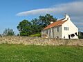
Garthorne Farm at Archdeacon Newton
-
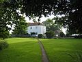
Hall Farm with Old Hall to its right
