Ariyalur facts for kids
Quick facts for kids
Ariyalur
|
|
|---|---|
|
Town
|
|

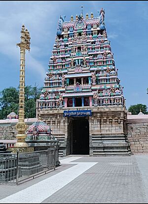
Sri Kothandaramaswamy perumal Temple is one of the famous temples of the town.
|
|
| Country | India |
| State | Tamil Nadu |
| District | Ariyalur |
| Region | Chola Nadu |
| Government | |
| • Type | Second Grade Municipality |
| • Body | Ariyalur Municipality |
| Elevation | 76 m (249 ft) |
| Population | |
| • Total | 28,902 |
| Languages | |
| • Official | Tamil |
| Time zone | UTC+5:30 (IST) |
| PIN |
621704,621713
|
| Telephone code | 91-4329 |
| Vehicle registration | TN 61 |
| Distance from Chennai | 267 kilometres (166 mi) |
| Distance from Trichy | 65 kilometres (40 mi) |
| Distance from Thanjavur | 42 kilometres (26 mi) |
| Precipitation | 620 millimetres (24 in) |
Ariyalur (Tamil: [aɾijaluːɾ]) is a town in the southern Indian state of Tamil Nadu. It is the main town and headquarters of the Ariyalur district. This area is known for having a lot of limestone, which is why there are seven cement factories and two sugar factories nearby. The town is about 310 kilometers (193 miles) away from Chennai, the capital city of Tamil Nadu.
Ariyalur used to be part of other districts, like Trichinopoly District and Tiruchirappalli district, before becoming its own district in 2007. The town is located in the rich farming area of the Cauvery Delta, and most people here work in agriculture.
Ariyalur is managed by a local government called a municipality, which was set up in 1994. In 2011, the town covered an area of 7.62 square kilometers (2.94 square miles) and had a population of 28,902 people. Ariyalur is part of an assembly area that chooses a representative for the Tamil Nadu Legislative Assembly every five years. It is also part of a larger area that elects a Member of Parliament (MP) for the national government every five years.
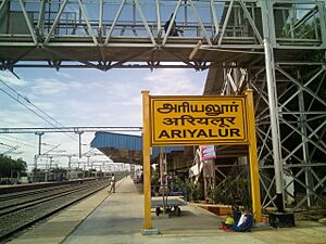
Roads are the main way to travel to and from Ariyalur, but it also has a train station. The closest seaport is Karaikal port, about 95 kilometers (59 miles) away. The nearest airport is the Tiruchirappalli International Airport, which is about 76 kilometers (47 miles) from the town.
Contents
History of Ariyalur
Ariyalur has a rich past, especially linked to the powerful Chola dynasty. It was once the hometown of Vallavaraiyan Vandiyadevan, a famous figure from Chola history. The later Chola kings even made Gangaikonda Cholapuram their capital, which is not far from Ariyalur.
After the Chola rule, the Vijayanagar Empire took over. Their kings, known as Nayaks, built many temples in Ariyalur, including the Kothandaramar temple.
Later, in the 1700s, the region saw many battles. In 1741, the Marathas invaded and captured Chanda Saheb, a local ruler. After he was freed, Chanda Saheb fought for control of the Carnatic region against Anwardeen and his son Mohammed Ali.
Mohammed Ali later took control of Ariyalur and a nearby area called Udayarpalayam. He did this because the local rulers (Poligars) didn't pay their taxes or help him in a rebellion. In 1765, with help from the British, Mohammed Ali's forces captured Ariyalur and Udayarpalayam. The local rulers had to flee. This takeover gave Mohammed Ali control of all his lands from Arcot to Tiruchirapalli.
After this, there was a struggle for power between Hyder Ali, and later his son Tipu Sultan, and the British. When Tipu Sultan died in 1801, the British took full control of the Carnatic region, and that's when the Tiruchirappalli District was formed.
Geography and Climate
Ariyalur is the main town of the Ariyalur District in Tamil Nadu. As mentioned, it's famous for its large amounts of limestone.
Understanding Ariyalur's Climate
Ariyalur has a hot semi-arid climate. This means it's hot or very hot all year round. It can be especially uncomfortable during the wet season, which is from October to December, when the northeast monsoon brings rain.
Because of the rain shadow created by the Western Ghats mountains, Ariyalur doesn't get much rain during the southwest monsoon. It's also too far inland to get enough rain from the northeast monsoon to be considered a tropical wet climate.
| Climate data for Ariyalur, Tamil Nadu (1991-2020 normals, extremes 1979-2020) | |||||||||||||
|---|---|---|---|---|---|---|---|---|---|---|---|---|---|
| Month | Jan | Feb | Mar | Apr | May | Jun | Jul | Aug | Sep | Oct | Nov | Dec | Year |
| Record high °C (°F) | 42.0 (107.6) |
42.4 (108.3) |
42.4 (108.3) |
45.4 (113.7) |
48.4 (119.1) |
42.0 (107.6) |
41.5 (106.7) |
49.6 (121.3) |
44.4 (111.9) |
42.2 (108.0) |
42.2 (108.0) |
42.4 (108.3) |
49.6 (121.3) |
| Mean maximum °C (°F) | 33.9 (93.0) |
35.8 (96.4) |
39.0 (102.2) |
40.6 (105.1) |
40.8 (105.4) |
39.5 (103.1) |
38.9 (102.0) |
39.3 (102.7) |
38.9 (102.0) |
37.0 (98.6) |
35.3 (95.5) |
33.8 (92.8) |
41.1 (106.0) |
| Mean daily maximum °C (°F) | 31.7 (89.1) |
33.6 (92.5) |
36.2 (97.2) |
38.0 (100.4) |
38.7 (101.7) |
37.0 (98.6) |
35.9 (96.6) |
36.4 (97.5) |
36.2 (97.2) |
34.2 (93.6) |
32.0 (89.6) |
30.8 (87.4) |
35.2 (95.4) |
| Daily mean °C (°F) | 26.6 (79.9) |
28.0 (82.4) |
30.3 (86.5) |
33.0 (91.4) |
33.2 (91.8) |
32.5 (90.5) |
31.7 (89.1) |
31.6 (88.9) |
31.0 (87.8) |
29.3 (84.7) |
27.4 (81.3) |
26.3 (79.3) |
30.3 (86.5) |
| Mean daily minimum °C (°F) | 21.4 (70.5) |
22.4 (72.3) |
24.3 (75.7) |
28.0 (82.4) |
27.7 (81.9) |
27.9 (82.2) |
27.5 (81.5) |
26.8 (80.2) |
25.8 (78.4) |
24.3 (75.7) |
22.7 (72.9) |
21.7 (71.1) |
25.3 (77.5) |
| Mean minimum °C (°F) | 19.9 (67.8) |
20.8 (69.4) |
21.0 (69.8) |
24.6 (76.3) |
23.5 (74.3) |
25.3 (77.5) |
25.2 (77.4) |
23.9 (75.0) |
23.3 (73.9) |
22.2 (72.0) |
20.8 (69.4) |
20.2 (68.4) |
19.6 (67.3) |
| Record low °C (°F) | 15.2 (59.4) |
13.0 (55.4) |
15.2 (59.4) |
20.0 (68.0) |
15.6 (60.1) |
21.9 (71.4) |
19.4 (66.9) |
20.6 (69.1) |
19.8 (67.6) |
18.2 (64.8) |
13.0 (55.4) |
15.2 (59.4) |
13.0 (55.4) |
| Average rainfall mm (inches) | 2.6 (0.10) |
0.9 (0.04) |
8.6 (0.34) |
18.5 (0.73) |
51.3 (2.02) |
32.4 (1.28) |
22.8 (0.90) |
88.7 (3.49) |
83.5 (3.29) |
114.7 (4.52) |
190.9 (7.52) |
93.2 (3.67) |
708.2 (27.88) |
| Average rainy days (≥ 2.5 mm) | 0.4 | 0.1 | 0.2 | 1.0 | 2.5 | 1.9 | 1.4 | 4.2 | 4.8 | 6.7 | 7.7 | 4.2 | 35.3 |
| Average relative humidity (%) | 80 | 72 | 63 | 61 | 61 | 61 | 62 | 66 | 71 | 80 | 85 | 83 | 70 |
| Source 1: India Meteorological Department | |||||||||||||
| Source 2: NOAA (humidity) | |||||||||||||
Economy and Jobs
Ariyalur is an important industrial center, especially for cement production. Big companies like UltraTech Cement, India Cements, Dalmia Cement, and Madras Cement have their factories here. The Tamil Nadu government's own TANCEM factory was the first to start making cement in Ariyalur.
Farming is also a major part of the economy. Sugarcane is a key crop grown for sale. There's a private sugar factory nearby that can process 3,000 tonnes of sugarcane every day.
Another important crop in the Ariyalur district is cashew. The soil in the district is mostly red and sandy, with some patches of black soil. This type of soil is very good for growing crops that don't need a lot of water. Rice is also grown in some areas.
People and Population
| Religious census | ||||
|---|---|---|---|---|
| Religion | Percent(%) | |||
| Hindu | 90.55% | |||
| Muslim | 4.61% | |||
| Christian | 3.81% | |||
| Sikh | 0.02% | |||
| Buddhist | 0.01% | |||
| Jain | 0.01% | |||
| Other | 0.97% | |||
| No religion | 0.01% | |||
| Historical population | ||
|---|---|---|
| Year | Pop. | ±% |
| 1971 | 17,305 | — |
| 1981 | 20,635 | +19.2% |
| 1991 | 24,141 | +17.0% |
| 2001 | 27,822 | +15.2% |
| 2011 | 28,902 | +3.9% |
|
||
According to the 2011 census, Ariyalur had a population of 28,902 people. There were 1,014 females for every 1,000 males, which is more females than the national average. About 2,977 children were under six years old.
The average literacy rate (how many people can read and write) in Ariyalur was 76.04%, which is higher than India's national average of 72.99%. Most people in Ariyalur are Hindus (80.55%), followed by Muslims (4.61%) and Christians (3.81%).
Town Services
The Tamil Nadu Electricity Board (TNEB) manages and distributes electricity to Ariyalur. The town gets its water supply from the Kollidam river through three different systems. In 2010–2011, about 2.3 million liters of water were supplied to homes every day. There are also many public water fountains that use groundwater.
About 11 metric tonnes of trash are collected from Ariyalur every day. The municipality's sanitation department collects the waste from homes and then sorts and disposes of it.
The town has a government hospital and twelve private hospitals and clinics to provide healthcare for its residents. There are also many streetlights to keep the town lit at night. The municipality runs a fish and meat market and a weekly market where people can buy goods.
Transportation in Ariyalur
Ariyalur is well-connected by roads. The National Highway NH136 passes through the town, connecting Perambalur and Thanjavur. There are also important State Highways like SH143 and SH139. The Ariyalur municipality takes care of over 29 kilometers (18 miles) of roads within the town.
Local buses provide transportation within Ariyalur and to nearby areas. There are also private mini-bus services. The town has a bus stand in the center, and regular inter-city bus services connect Ariyalur to other cities and towns like Trichy, Chidambaram, Jayankondam, Perambalur, and Thanjavur.
The Ariyalur railway station is an important stop on the main train line that connects Chennai and Tiruchirappalli. Many daily trains, such as the Pallavan Express and Rockfort Express, connect Ariyalur to major cities like Chennai Egmore and Tiruchirappalli Junction.
The closest seaport is Karaikal port, which is about 95 kilometers (59 miles) away. The nearest airport is the Tiruchirappalli International Airport, located about 76 kilometers (47 miles) from Ariyalur.
See also
 In Spanish: Ariyalur para niños
 | Tommie Smith |
 | Simone Manuel |
 | Shani Davis |
 | Simone Biles |
 | Alice Coachman |


