
Arkansas Highway 2 facts for kids
Quick facts for kids
[[File:|x70px|alt= marker]] |
||||
|---|---|---|---|---|
_map.svg) |
||||
| Route information | ||||
| Maintained by AHD | ||||
| Length | 195 mi (314 km) | |||
| Existed | 1926–July 1, 1931 | |||
| Major junctions | ||||
|
||||
| East end | ||||
| Location | ||||
| Counties: | Ashley, Chicot, Columbia, Lafayette, Miller, Union | |||
| Highway system | ||||
| Arkansas Highway System Interstates • US • State Business • Spurs • Scenic
|
||||
State Road 2, also called AR 2 or Hwy. 2, was an important old road in Arkansas. It stretched for about 195 miles (314 km) across the southern part of the state. The road started in Texarkana and went east. It crossed the Mississippi River near Lake Village. From there, it continued into Mississippi as Mississippi Highway 10.
In 1931, a new road called U.S. Highway 82 (US 82) took its place. So, State Road 2 doesn't exist anymore. The Arkansas Highway Department (AHD) took care of the road. Today, much of the current US 82 follows the same path as the old State Road 2. You can still see a small part of the original road near Garland. It's called the Old Arkansas 2-Mayton Segment and is a historic landmark.
Contents
What Was State Road 2?
State Road 2 was a very important road for southern Arkansas. It connected many towns and cities. The road helped people travel between the Arkansas Timberlands (the western part of the state) and the Arkansas Delta (the eastern part).
Connecting Towns and Cities
This road linked six different county seats. These are the main towns in each county. State Road 2 also had three bridges where drivers had to pay a fee to cross. These were called toll bridges.
History of the Road
Over the years, some parts of State Road 2 were changed. This happened as towns grew bigger and needed better roads. New sections were built to go around cities, making travel smoother.
Changes Near Garland
In the 1980s, a new bridge was built over the Red River near Garland. This meant the old part of Highway 2 that went into Garland was no longer needed. Now, that old section is called Highway 134.
The Old Arkansas 2-Mayton Segment
North of Garland, there was a curvy part of the highway. In 1948, a new, straighter road was built to replace it. This made driving much safer and faster. The old curvy part is now known as County Roads 122 and 123. This section is special because it's one of the few places where you can still drive on the original 1926 pavement of State Road 2. It was added to the National Register of Historic Places in 2008. This means it's an important historical site.
Changes Near Lake Village
East of Lake Village, the original Highway 2 used to follow Lake Chicot. It went to an old ferry crossing near Greenville, Mississippi. That old path is now called Highway 144. It goes from Lake Village past Lake Chicot State Park to the Mississippi River levee.
When the Benjamin G. Humphreys Bridge opened in 1940, US 82 was rerouted. It now goes south of Lake Chicot. This new path is mostly the same as the current Greenville Bridge.
Images for kids
-
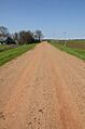
Old Arkansas 2, Mayton Segment

