
Auchenflower, Queensland facts for kids
Quick facts for kids AuchenflowerBrisbane, Queensland |
|||||||||||||||
|---|---|---|---|---|---|---|---|---|---|---|---|---|---|---|---|

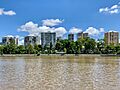
Auchenflower seen from the Brisbane River
|
|||||||||||||||

Auchenflower
Location in Queensland
|
|||||||||||||||
| Population | 6,053 (2021 census) | ||||||||||||||
| • Density | 4,040/km2 (10,500/sq mi) | ||||||||||||||
| Postcode(s) | 4066 | ||||||||||||||
| Area | 1.5 km2 (0.6 sq mi) | ||||||||||||||
| Time zone | AEST (UTC+10:00) | ||||||||||||||
| LGA(s) | City of Brisbane (Paddington Ward) |
||||||||||||||
| State electorate(s) |
|
||||||||||||||
| Federal Division(s) | Ryan | ||||||||||||||
|
|||||||||||||||
Auchenflower is a lively suburb located in the inner western part of Brisbane, Queensland, Australia. It sits right next to the Brisbane River. In 2021, about 6,053 people called Auchenflower home.
Contents
Exploring Auchenflower
Auchenflower is found about 2.5 kilometres (1.5 miles) west of the main city area of Brisbane. It's known for its rolling hills and lovely green spaces. These areas offer great views and places for people to relax and play.
A Glimpse into History

Long ago, Auchenflower was made up of large country estates. One of these estates was named "Auchenflower" around 1880 by a person named Thomas McIlwraith. The name "Auchenflower" comes from a Gaelic word meaning "field of flowers."
From 1900 to 1962, people in Auchenflower could travel by tram. These trams ran along Milton Road, connecting Auchenflower to Toowong. The tram services stopped after a big fire at the Paddington tram depot.
A school called Auchenflower Infants' Provisional School opened its doors on January 30, 1922. It taught young children for many years before closing in 1960.
St Alban the Martyr Anglican Church was officially opened in 1923. A new building for the church was started in 1954. The church closed in 2015, and the land is now being used for new homes.
In 1975, the very first NightOwl convenience store opened in Auchenflower. This was a new type of shop where you could buy things late at night.
For a while, from 1975 to 1986, Auchenflower was considered part of the nearby suburb of Toowong. But on November 16, 1986, Auchenflower became its own official suburb.
In January 2011, Auchenflower experienced some flooding. This was part of the larger 2010–11 Queensland floods that affected many areas in Queensland.
Who Lives in Auchenflower?
In 2021, Auchenflower had a population of 6,053 people. Most people living here were born in Australia. Other people came from countries like England, New Zealand, India, and China. Most residents speak English at home.
Important Places
Auchenflower has some buildings that are important because of their history. These are called heritage-listed sites. They include:
- Raymont Lodge, located at 45 Cadell Street.
- Moorlands, found at 451 Coronation Drive. This building is now part of the Wesley Hospital grounds.
Schools Nearby
There are no schools directly in Auchenflower. Students usually go to primary schools in nearby suburbs. These include Milton State School (in Milton), Rainworth State School (in Bardon), and Toowong State School (in Toowong). For high school, students might attend Kelvin Grove State College (in Kelvin Grove) or Indooroopilly State High School (in Indooroopilly).
Local Facilities
The Wesley Hospital is a large private hospital in Auchenflower. Its main entrance is on Chasely Street. The hospital is very close to the Auchenflower railway station.
Auchenflower Stadium is a basketball centre in the suburb. It's also known as NAB Stadium or sometimes "The Auchendome."
Getting Around Auchenflower

By Train: The Auchenflower railway station is on the Ipswich railway line. It's a convenient way to travel to and from the city.
By Bus: Many bus routes serve Auchenflower, connecting it to other western suburbs. These buses are run by Transport for Brisbane.
By Road: Auchenflower has two main roads: Coronation Drive and Milton Road. Both roads lead from the Brisbane CBD (city centre) to the western suburbs. There have been plans for a major road tunnel system under areas like Auchenflower to help with traffic.
By Bicycle: The Bicentennial Bikeway runs along the Brisbane River. This path is great for cyclists and connects Auchenflower to the Brisbane CBD and Toowong.
Images for kids
-
Auchenflower seen from the Brisbane River
-
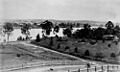
Looking southward across the Brisbane River from Auchenflower across Chasely Street to West End around 1910
-
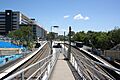
Auchenflower railway station
