Aurora, Oregon facts for kids
Quick facts for kids
Aurora, Oregon
|
||
|---|---|---|

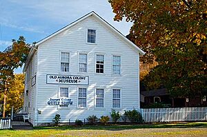
Old Aurora Colony Museum
|
||
|
||

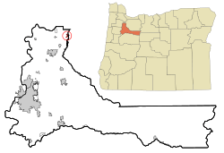
Location in Oregon
|
||
| Country | United States | |
| State | Oregon | |
| County | Marion | |
| Incorporated | 1893 | |
| Area | ||
| • Total | 0.48 sq mi (1.25 km2) | |
| • Land | 0.48 sq mi (1.25 km2) | |
| • Water | 0.00 sq mi (0.00 km2) | |
| Elevation | 167 ft (51 m) | |
| Population
(2020)
|
||
| • Total | 1,133 | |
| • Density | 2,340.91/sq mi (903.15/km2) | |
| Time zone | UTC-8 (Pacific) | |
| • Summer (DST) | UTC-7 (Pacific) | |
| ZIP code |
97002
|
|
| Area code(s) | 503 | |
| FIPS code | 41-03300 | |
| GNIS feature ID | 2409758 | |
| Website | www.ci.aurora.or.us | |
Aurora is a city located in Marion County, Oregon, in the United States. It was officially made a city in 1893. Before that, it was known as the Aurora Colony. This colony was a special religious community. It was started in 1856 by William Keil and John E. Schmit. William Keil named the settlement after his daughter. In 2020, about 1,133 people lived there. Aurora is also part of the larger Salem Metropolitan Statistical Area.
Contents
Geography of Aurora
Aurora is a small city. The United States Census Bureau says it covers about 0.48 square miles (1.25 square kilometers). All of this area is land.
The Pudding River flows north. It runs just east of Aurora.
Aurora's Climate
Aurora has a climate with warm, dry summers. The average monthly temperatures do not go above 71.6°F (22°C). This type of weather is called a warm-summer Mediterranean climate. On climate maps, it is known as "Csb."
| Climate data for Aurora State Airport (1991–2020 normals, extremes 1997–present) | |||||||||||||
|---|---|---|---|---|---|---|---|---|---|---|---|---|---|
| Month | Jan | Feb | Mar | Apr | May | Jun | Jul | Aug | Sep | Oct | Nov | Dec | Year |
| Record high °F (°C) | 65 (18) |
69 (21) |
79 (26) |
89 (32) |
99 (37) |
114 (46) |
108 (42) |
106 (41) |
100 (38) |
90 (32) |
75 (24) |
67 (19) |
114 (46) |
| Mean maximum °F (°C) | 58.1 (14.5) |
61.2 (16.2) |
70.0 (21.1) |
79.6 (26.4) |
87.4 (30.8) |
91.0 (32.8) |
97.0 (36.1) |
97.8 (36.6) |
92.7 (33.7) |
77.7 (25.4) |
64.7 (18.2) |
58.5 (14.7) |
100.3 (37.9) |
| Mean daily maximum °F (°C) | 48.5 (9.2) |
52.5 (11.4) |
57.1 (13.9) |
62.0 (16.7) |
69.2 (20.7) |
74.5 (23.6) |
83.1 (28.4) |
83.3 (28.5) |
77.4 (25.2) |
64.3 (17.9) |
53.7 (12.1) |
47.6 (8.7) |
64.4 (18.0) |
| Daily mean °F (°C) | 42.4 (5.8) |
44.7 (7.1) |
48.3 (9.1) |
52.3 (11.3) |
58.7 (14.8) |
63.4 (17.4) |
69.6 (20.9) |
69.8 (21.0) |
64.8 (18.2) |
54.9 (12.7) |
46.7 (8.2) |
41.8 (5.4) |
54.8 (12.7) |
| Mean daily minimum °F (°C) | 36.3 (2.4) |
37.0 (2.8) |
39.4 (4.1) |
42.6 (5.9) |
48.3 (9.1) |
52.3 (11.3) |
56.1 (13.4) |
56.3 (13.5) |
52.2 (11.2) |
45.5 (7.5) |
39.7 (4.3) |
35.9 (2.2) |
45.1 (7.3) |
| Mean minimum °F (°C) | 24.9 (−3.9) |
26.4 (−3.1) |
29.8 (−1.2) |
33.2 (0.7) |
37.7 (3.2) |
44.4 (6.9) |
49.0 (9.4) |
49.0 (9.4) |
42.5 (5.8) |
33.8 (1.0) |
27.2 (−2.7) |
23.1 (−4.9) |
20.2 (−6.6) |
| Record low °F (°C) | 16 (−9) |
19 (−7) |
25 (−4) |
29 (−2) |
33 (1) |
41 (5) |
45 (7) |
44 (7) |
36 (2) |
26 (−3) |
17 (−8) |
10 (−12) |
10 (−12) |
| Average precipitation inches (mm) | 5.48 (139) |
4.03 (102) |
4.39 (112) |
3.37 (86) |
2.55 (65) |
1.47 (37) |
0.43 (11) |
0.52 (13) |
1.58 (40) |
3.70 (94) |
5.80 (147) |
6.23 (158) |
39.55 (1,005) |
| Average precipitation days (≥ 0.01 in) | 20.3 | 17.4 | 19.2 | 16.7 | 13.3 | 8.7 | 3.0 | 3.5 | 7.6 | 15.3 | 20.3 | 20.2 | 165.5 |
| Source: NOAA | |||||||||||||
Aurora's Population and People
| Historical population | |||
|---|---|---|---|
| Census | Pop. | %± | |
| 1900 | 122 | — | |
| 1910 | 190 | 55.7% | |
| 1920 | 229 | 20.5% | |
| 1930 | 215 | −6.1% | |
| 1940 | 228 | 6.0% | |
| 1950 | 242 | 6.1% | |
| 1960 | 274 | 13.2% | |
| 1970 | 306 | 11.7% | |
| 1980 | 523 | 70.9% | |
| 1990 | 567 | 8.4% | |
| 2000 | 655 | 15.5% | |
| 2010 | 918 | 40.2% | |
| 2020 | 1,133 | 23.4% | |
| U.S. Decennial Census | |||
2020 Census Information
In 2020, the census showed that 1,133 people lived in Aurora. There were 336 households, which are groups of people living together. Most residents, about 79.3%, were White. Other groups included African American (1.3%), Native American (1.5%), and Asian (0.9%). About 16.4% of the population was Hispanic or Latino.
About 28.5% of households had children under 18. Many households (66.1%) were married couples. The average age in Aurora was 42.4 years. About 20.7% of residents were under 18. Also, 17.1% were 65 or older.
The average income for a household in Aurora was $90,357. This is much higher than the average income for Oregon, which was $65,667. Only 2.4% of people in Aurora lived in poverty. This is lower than Oregon's poverty rate of 12.4%.
2010 Census Information
The census in 2010 counted 918 people living in Aurora. There were 336 households and 256 families. The city had about 1912.5 people per square mile. Most residents (89.7%) were White. About 10.9% of the population was Hispanic or Latino.
About 37.5% of households had children under 18. Most households (64.0%) were married couples. The average age in the city was 39.6 years. About 27.8% of residents were under 18.
Education in Aurora
The North Marion School District serves Aurora. It has four schools that are close to each other. These include North Marion Primary School, North Marion Intermediate School, North Marion Middle School, and North Marion High School.
Fun Places to Visit
- Old Aurora Museum: This museum teaches about the history of the Old Aurora Colony.
- Aurora Mills Architectural Salvage: This is a large antique shopping area. It is in an old seed cleaning mill built in 1890.
- Mainstreet Mercantile Antiques: This is another one of the city's bigger antique shops.
Transportation
Aurora State Airport
The Aurora State Airport is located about 1 mile (1.6 km) northwest of Aurora. The State of Oregon owns this airport. The Oregon Department of Aviation manages it.
Aurora's Economy
Life Flight Network has its main office at the Aurora State Airport. It is the biggest non-profit air ambulance service in the country. They help people who need urgent medical care. They use helicopters and airplanes to move patients between hospitals or from accident scenes. They also offer ground ambulance services. Life Flight Network has been helping people since 1978. They have locations in Oregon, Washington, Idaho, and Montana. About 900 people work for the company.
Columbia Helicopters is also in Aurora. This company fixes and maintains helicopters.
See also
 In Spanish: Aurora (Oregón) para niños
 | Jackie Robinson |
 | Jack Johnson |
 | Althea Gibson |
 | Arthur Ashe |
 | Muhammad Ali |


